


Observing the polar ice caps
Benoît Legrésy, Frédérique Rémy (LEGOS/CNES/CNRS/UPS, France), Patrick Vincent (CNES, France)
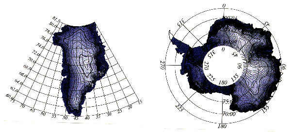
The launch of the ERS-1 satellite gave new impetus to satellite altim-etry work over the polar ice-caps. It is now possible to accurately map 80% of Antarctica and virtually all of Greenland (Figure 1 A, B).
The TOPEX dual frequency altimeter data were used to look at radar frequency-dependant offsets over continental ice.
Observing the polar ice caps via altim-etry meets at least three distinct objectives:
- constraining ice flow models by studying the shape of the ice,
- monitoring their mass budgets by successive topographic surveys, requiring 10-cm accuracy,
- describing and monitoring trends in climatologic surface characteristics (type of snow, surface roughness, and so on) by analysing radar echoes.
On the polar ice caps the altimeter height can be biased by the penetration of radar waves into the snowpack. Estimating the bias is difficult because of the many factors affecting surface and volume backscattering. The radar echo depends on the surface micro-roughness, the kilome-tre-scale roughness, the stratification of the snowpack, the radar extinction in the snow, and the antenna gain pattern. The echo therefore depends on the frequency used. The TOPEX dual-frequency altimeter provides a means of detecting the bias empirically (Rémy et al., 1996) by increasing the volume of data relative to the number of unknowns. TOPEX/POSEIDON covers only a small part of Greenland and does not cover Antarctica, but is useful for an initial analysis.
The measured height difference between C-band and Ku-band is due to lengthening of the radar signal path time in the ionosphere. The same phenomenon exists on the polar ice caps, but a correction is interpolated from ocean data from either side of the ice cap. By theoretical simulations, from realistic topographic surveys, it can be shown (Legresy, 1995) that C-band is more sensitive to penetration because there is less extinction (through diffusion by snow grains). It can also be shown that at scales over 1 km, the C-band radar echo is very insensitive to surface slope and curvature.
We looked at 22 tracks over Greenland in the second TOPEX cycle (3 to 12 October 1992). The radar echoes were reprocessed by fitting an erf-type function (Femenias et al., 1993); errors affecting both frequencies simultaneously were not corrected.
The altimeter backscattering in each band was mapped; see Figures 2A and 2B. The mean backscattering bias of 4 dB between the two bands, also observed over the ocean, was removed. We also mapped the radar echo trailing edge (Figure 2 C, D), showing the volume or slope (or mispointing) signal when it is high, and specular reflection from the ground when it is particularly low (Legrésy and Rémy, 1996).
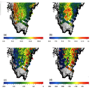
Figure 2 : from the TOPEX altimeter: (A) C-band and (B) Ku-band backscattering in dB, (C) C-band and (D) Ku-band trailing edge parameter, in 10-4 Np/gate
Note the consistent geophysical signal. Ku-band backscattering is weak on the slopes and stronger at higher altitudes. In C-band, backscattering is very strong in the west but comparable to Ku-band in the centre and east. The radar echo trailing edge is particularly weak in the west in both bands, while the centre and east both show higher values.
These values suggest a strong volume signal in the centre and to the east of the ice cap. They also suggest a specular-type surface signal in the west (only a small local area contrib-utes to the radar echo).
C-band, being more sensitive to penetration, is seen lower in the centre and east (Figure 3). At the western end of the continent, the surface slope is steep: greater than 0.7. It is greater than the Ku-band antenna half-aperture, which explains the weak observed backscattering. The measured height is therefore under-estimated in Ku-band, because of the antenna gain, while the C-band measurement is robust. To estimate geophysical parameters, combining the bands is therefore a way of describing the surface and estimating the radar penetration depth, linked to the stratification and size of the snow grains. However, the trailing edge values in C-band are always very much lower than normal (response from a diffuse surface), suggesting that the sensitivity of backscattering to roughness must be different from that in Ku-band, as ocean studies suggest (Chapron et al., 1996).
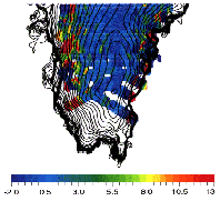
Figure 3 : differences in measured heights, in metres, between C-band and Ku-band
The study showed that it is possible to detect, at least empirically, the penetration of radar waves into the snowpack using dual-frequency altimetry. It also showed that in areas with marked relief, altimetry using lower radar frequencies is more robust, especially in specular areas. The frequency bands can complement each other, and be used to detect substantial measurement errors (c.f. the 10-cm-scale ionospheric signal). The launch of the ENVISAT satellite with a dual-frequency radar altimeter (Ku and S), offering the same cover-age as ERS, brings the promise of great progress in altimetry over the ice caps. The Jason altimeter satellite, to carry a Ku-band and C-band altimeter, in conjunction with ENVISAT, should provide good calibration of radar frequency-dependent effects.
References
- Chapron, B., K. Katsaros, T. Elfouhaily and D. Vandemark, A note on relationships between sea surface roughness and altimeter backscatter, Remote Sensing and Global Modelling, 869-878, 1995.
- Féménias, P., Rémy F., Raizonville P. and J.F. Minster, Analysis of satellite altimeter height measurements above ice sheet, J. of Glaciol., 133, 591-600, 1993.
- Legrésy, B. "Etude du retracking des formes d'onde altimétriques au-dessus des calottes polaires", rapport CNES CT/ED/TU/UD/96.188, contract n° 856/2/95/CNES/006, 1995.
- Legrésy B. and F. Rémy, Surface characteristics of the Antarctica ice sheet and altimetric observations, à paraître dans J. of Glaciology, 1996.
- Rémy F., B. Legrésy, S. Bleuzen,P. Vincent, and J.F. Minster, Dual-frequency TOPEX altimeter observation above Greenland. J. of Electromagnetic waves and application. vol. 10, 1505-1523, 1996b.