


TOPEX/POSEIDON vs. ocean general circulation model in the Tropical Atlantic
Sabine Arnault, N. Ferry, M-P. Gauthier (LODYC UMR121 CNRS/ORSTOM/ UMPMC, France), J. Poitevin (Météo-France, SCEM/PREVI/MAR, France), H. Roquet (Météo-France Lannion, France)
We know how important the ocean is to an understanding of global climatic variability over long periods. But given the human and financial problems in obtaining long, high-quality oceanographic data series at sea, numerical models and satellite observations are vital to a large-scale four-dimensional picture of the ocean.
Introduction
Models and empirical analyses agree that the Atlantic plays an important role in climate variability.
The temporal fluctuations in the Atlantic ocean exhibit a broader range of scales and physical processes than in the Pacific, although they are less marked. For example, a very low frequency signal, with a ten-year scale, appears in changes in sea surface temperature, affecting geo-graphical areas well outside the tropics. These processes are proba-bly related to ocean thermohaline circulation.
Other interannual fluctuations at time-scales shorter than ten years, superimposed on the seasonal cycle, are also present in the tropical Atlantic, usually in the Gulf of Guinea. These fluctuations seem more to resemble the dy-namics observed during the eastern Pacific warming brought on by El Niño.
We therefore used TOPEX/POSEIDON altimeter measurements and the results of an Ocean General Circulation Model (OGCM) to study low-frequency sea-level variability in the tropical Atlantic between 1992 and 1995 (Ferry, 1996).
The OGCM we used was based on version OPA7 of the primitive equation model developed at the Laboratoire d'Océanographie Dynamique et de Climatologie (LODYC), UMR 121 CNRS/ORSTOM/UPMC) (see, for example, Blanke and Delecluse, 1993 for a more complete description of the model). This has been used in the Observatoire Permanent de l'Atlantique Tropical (OPERA). OPERA, which is supported by the Programme National d'Etudes de la Dynamique du Climat, was initiated as part of the French contribution to the Tropical Ocean Global Atmosphere (TOGA) program.
It is being conducted in collaboration between the Institut Français de Recherche Scientifique pour le Développement en Coopération (ORSTOM), the Centre National de la Recherche Scientifique (CNRS), IFREMER and METEO-France.
The aim is to monitor ocean circulation in the tropical Atlantic in real time. The different forcing processes used in the ocean model are from the ARPEGE meteorological model. The fluxes are linearly interpolated every six hours. The model includes 17 vertical levels, with high resolution in the thermocline, 145 points of longitude and 96 points of latitude from 100W to 15E and 33°S to 54°N. The grid spacing varies in latitude from 0.5° at the Equator to 1.5° at 50N, and is roughly 0.75 in longitude. At the basin's northern and southern boundaries, temperature and salinity were relaxed to the Levitus climatology (1982). Sea level was obtained every five days by the preconditioned conjugated gradient method, then averaged monthly in a 2° longitude by 1° latitude grid from 80°W to 20°E, 30°N to 30°S.
The processed TOPEX/POSEIDON altimeter measurements covered the period October 1992 to September 1995. The usual corrections for iono-sphere, wet and dry troposphere, electromagnetic bias and tide errors were applied, following the recommendations in the AVISO User Handbook (version 3.0, July 1996). Sea-level anomalies calculated by the repeat-track method were smoothed and resampled every 10 km before being averaged using the same space-time scheme as the model results.
Seasonal dynamic topography signal from the tropical Atlantic
The dynamic topography of the tropical Atlantic is characterised by a series of zonal crests and troughs overlaid on a general east-west slope (Merle, 1978). Two high-variability areas appear: in the north-west and in the Gulf of Guinea. The altimetry and the model both exhibit this pattern perfectly (fig. 1). A 5 cm variability area appears first between 20° and 40°W / 2-10°N, in the North-Equatorial CounterCurrent (NECC) area.
In fact it appears as two extreme strands, separated by a zone of relative minimum relief located below the average position of the InterTropical Convergence Zone (ITCZ).
At the eastern end of the basin, in the Gulf of Guinea, the values also increase by around 5 cm along the African coast. This high variability can be accounted for by the appearance of the annual summer equatorial upwelling in the area.
The model also shows strong variability at the southern boundary of the basin, but this must be related to a local artifact due to the relaxation towards the Levitus climatology.
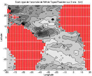
Figure 1 : (A) Standard deviation (in cm) over 36 months of TOPEX/POSEIDON measurements
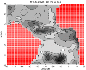
B) Standard deviation (in cm) over 36 months of numerical modeling
An Empirical Orthogonal Function (EOF) analysis on the seasonal cycle of the difference between the altimeter and model sea levels helps to locate and estimate the main differences between the two quantities. The first function alone explains 64% of the total variance.
It shows that the difference is generally slight, less than 2 cm on average, i.e. less than the accuracy usually stated for TOPEX/POSEIDON (fig. 2).
It mainly indicates a discrepancy in the amplitude of the seasonal variabil-ity in the NECC region and in the Gulf of Guinea, the amplitude simulated by the model being smaller than that of TOPEX/POSEIDON.
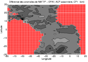
Figure 2 : (A) First EOF eigenvector (in cm)
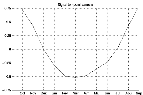
(B) time signal for the (altimeter minus model) difference analysis.
Figure 3 shows the temporal trend in sea-level at 4.5°N between 1992 and 1995, as calculated from altimetry and from the model. This latitude goes through both the maximum variability areas described above (NECC and Gulf of Guinea). The agreement is outstanding, even though the space-time trend in the model is smoother than in the TOPEX/POSEIDON data.
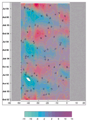
Figure 3 : (A) Longitude-time plot of TOPEX/POSEIDON sea level (cm) along 4.5°N, October 1992 to September 1995.
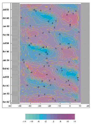
(B) Longitude-time plot of model sea level (cm) along 4.5°N, October 1992 to September 1995
At the western end of the basin, in the NECC core, the seasonal cycle is very marked, with a maximum signal (+8 to 10 cm) at the end of northern summer and start of autumn, and minimum (-8 to 10 cm) in the spring.
In the Gulf of Guinea, a negative signal in summer (-6 to 8 cm) corresponds to the main upwelling. The secondary upwelling season in winter also corre-sponds to a second extreme value, though weaker and limited to the far eastern end of the basin.
The most interesting feature of the figure is the appearance of a very strong positive anomaly, early in 1995.
The 1995 warm event in the tropical Atlantic
Several partial warmings of the tropical eastern Atlantic have been observed in the last few years. Some were revealed in the satellite altimetry (Arnault and Cheney, 1994).
The strongest included those of 1964, 1966, 1968, 1984 and 1988.
We are a long way from understanding the dynamics of these events, often compared to El Niño events in the Pacific. Using heat content anomalies integrated from the surface down to 400 m, White (1994) studied northward propagations (15 to 30 cm/s) of the signal along the African coasts from 1979 to 1991 as "El Niño Southern Oscillation boundary waves". Figure 4 shows the space-time trend in our interannual sea level anomalies along the African coast. The prominent 1995 event exceeds 4 cm. However there seems to be no propagation in the model results. North of the Equator, the TOPEX/POSEIDON data seem to show a northward shift in the signal, at around 20 cm/s. Propagation is also seen south of the Equator, at a very similar velocity but in the opposite direction. The result thus contradicts White's 1994 observations.
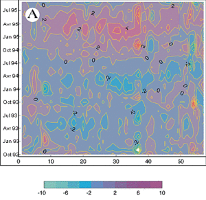
Figure 4 : (A) Latitude-time plot of TOPEX/POSEIDON interannual sea level anomaly (cm) along the African coast, October 1992 to September 1995.
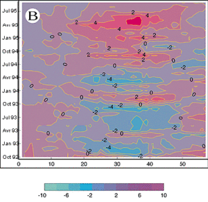
(B) Latitude-time plot of model interannual sea level anomaly (cm) along the African coast, October 1992 to September 1995
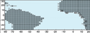
(C) Location numbers along the African coast.
Conclusion
The results of an OGCM and of TOPEX/POSEIDON agree well with each other over a seasonal cycle in the tropical Atlantic. A marked interannual anomaly is also observed from the two data sets, but a more detailed analysis of the event reveals differ-ences. The dynamics and timing of the phenome-non are still unexplained. The next stage in the work will be to analyse the results of a numerical experiment in which TOPEX/ POSEIDON data are assimilated to overcome some of the problems in the model such as uncertainty on the forcing processes, and poor boundary or initial conditions.
Acknowledgements
The authors wish to thank the dynamic AVISO team and Yves Ménard (CNES) for their enlight-ened suggestions during processing of the altimeter data. Work by S. Arnault and M-P. Gauthier was funded by ORSTOM, J. Poitevin, H. Roquet and N. Ferry by Météo France. The Programme National de Télédétection Spatiale also contributed to funding the study.
References
- Arnault S. and R.E. Cheney, Tropical Atlantic sea level variability from Geosat (1985-1989). Journal of Geophysical Research, 99, C9, 18207-18223, 1994.
- Blanke B. and P. Delecluse, Variability of the tropical Atlantic ocean simulated by a general circulation model with two different mixed layer physics. Journal of Physical Oceanography, 23, 1363-1388, 1993.
- Ferry N., Comparaison des mesures altimétriques TOPEX/POSEIDON avec les résultats d'un modèle de circulation générale océanique en Atlantique tropical de 1992 à 1995. Rapport de stage d'approfondis-sement, Ecole Nationale de la Météorologie, document LODYC, 101 pp, 1996.
- Levitus S., Climatological atlas of the world ocean. NOAA prof. paper 13, US governement printing office, Washington DC, 1982.
- Merle J., Atlas hydrologique saisonnier de l'océan Atlantique intertropical. Travaux documents ORSTOM, 184 pp, 1978.
- White W.B., Slow El Niño southern oscillation boundary waves. Journal of Geophysical Research, 99, C11, 22737-22751, 1994.