Calibrating Swot over the oceans
Image of the Month - April 2023

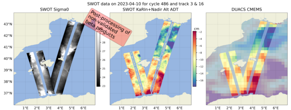
Swot (Surface Water and Ocean Topography) is the very first mission with a swath altimeter-interferometer. This concept enables to detail sea surface heights over entire areas in one passage, thus shifting from "along-track" thread-like data to images.
Up till now, calibrating altimetry data has been made using ground sites just under the track, as well as intercomparing with in situ networks or also by computing statistical indicators. To calibrate and validate a whole image, though, having data for comparison in only one point, or a collection of wide-spread points is definitely not enough.
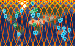
A series of oceanographic campaigns has been set up to cover entire areas with in situ measurements which can be compared with the Swot ones. They are using in particular (but not only) the "crossovers", where two Swot swathes are crossing each other, thus benefitting of the internal coherency of the instrument to look at the variations (and check on their likelyhood). "Adopt a crossover" is a Clivar-supported initiative which has this objective of comparing in situ and Swot measurement for the calibration of the mission, during the dedicated phase first and also on the long term afterwards. A series of at-sea campaign are taking and will take place, especially during the one-day long orbit phase of Swot (beginning this month (April 2023) for the next three months, up to July 2023), located in a large part in the crossover areas and their vicinity. To help the crews and scientists involved, they are provided with preliminary maps, even though the data are not yet fully calibrated and validated, so that they can select interesting places to record in situ measurements and compare Swot data with them as soon as possible. The existing "multimission gridded" datasets, which represent the highest resolution image-like data available today are also provided.
The data "CalVal" will continue on during the whole mission with the "science" 21-day orbit after July 2023, to certify the data quality, and fine-tune and improve the processing - as it has been done for all altimetry missions since the first ones.
See also:
- Image of the Month, February 2002: Well-calibrated measurements
- Image of the Month, July 2018: Adopting a Swot crossover for biophysical studies
- Data: CalVal
- Missions: Swot
Other web sites on this topic:
- Swot AdAC Consortium
- Swot at Cnes
- Swot at JPL
References:
(*) The Level-3 algorithms may include a Swot-updated variant of the following papers:
- Dibarboure, G., C. Ubelmann, B. Flamant, F. Briol, E. Peral, G. Bracher, O. Vergara, Y. Faugère, F. Soulat, N. Picot, 2022, Data-Driven Calibration Algorithm and Pre-Launch Performance Simulations for the SWOT Mission. Remote Sens. 2022, 14(23), 6070; https://doi.org/10.3390/rs14236070
- Pujol, M.-I., S. Dupuy, O. Vergara, A. Sánchez Román, Y. Faugère, P. Prandi, M.-L. Dabat, Quentin Dagneaux, M. Lievin, E. Cadier, G. Dibarboure, N. Picot, 2023, Refining the Resolution of DUACS Along-Track Level-3 Sea Level Altimetry Products, Remote Sens. 2023, 15(3), 793; https://doi.org/10.3390/rs15030793
- Faugère, Y., G. Taburet, M. Ballarotta, M.-I. Pujol, J. F. Legeais, G. Maillard, C.Durand, Q. Dagneau, M. Lievin, A. Sánchez Román, G. Dibarboure, 2022, DUACS DT2021: 28 years of reprocessed sea level altimetry products, EGU General Assembly 2022, Vienna, Austria, 23–27 May 2022, EGU22-7479, https://doi.org/10.5194/egusphere-egu22-7479
- Tréboutte, A., B. Carpentier, P. Prandi, Y. Faugère, G. Dibarboure, 2022, Karin noise filtering using AI techniques. Swot Science Team Meeting, Chapel Hill (Virginia, USA) and Toulouse (France), June 2022
- Jousset S., S. Mulet , J. Wilkin, E. Greiner, G. Dibarboure, N. Picot, 2022, New global Mean Dynamic Topography CNES-CLS-22 combining drifters, hydrological profiles and High Frequency radar data, 2022 Ocean Surface Topography Science Team Meeting, Venice, Nov. 2022, https://doi.org/10.24400/527896/a03-2022.3292
- Carrère, L., F. Lyard, M. Cancet, D. Allain, M.-L. Dabat, E. Fouchet, E. Sahuc, Y. Faugère; G. Dibarboure, N. Picot, 2022, A new barotropic tide model for global ocean: FES2022. 2022 Ocean Surface Topography Science Team Meeting, Venice, Nov. 2022, https://doi.org/10.24400/527896/a03-2022.3287
- Schaeffer, P., S. Bruisma, 2022, The new CNES-CLS 2022 marine gravity anomaly model: first validation in the Mediterranean, 2022 Ocean Surface Topography Science Team Meeting, Venice, Nov. 2022, 2022 Ocean Surface Topography Science Team Meeting, Venice, Nov. 2022, https://doi.org/10.24400/527896/a03-2022.3308


