


Finer currents
Image of the Month - May 2010


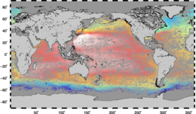
Agulhas mean dynamic topography (left, in cm) and current speed deduced from it (right, in cm/s). The use of seven more years of in situ data and of the Grace gravimetry satellite data enabled to precise the mean current path with respect to the old version (Credits Cnes/CLS).
The mean currents are difficult to extract from altimetry. At least, from altimetry alone. But mixing gravimetry, oceanographic in situ (Argo, drifting buoys...) and altimetry data enable to discriminate between the variable and the mean parts. This leads to a "mean dynamic topography", i.e. the mean topography of the ocean due to its moving parts. As it is the case for the smaller features like the eddies, mean currents are moving clockwise or counter-clockwise, depending on the hemisphere and on the fact they are turning around "hills" or "valleys" of the ocean surface.
With more and more data, from altimetry, but also from gravimetry and in situ, a mean dynamic topography with finer resolution is now possible. The Goce satellite (launched 17 March 2009) will help refine it even more.
![]()
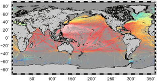
In situ dynamic height estimates used for the new version of the Mean Dynamic Topography (left), and for the old one (right). These data are used to compute the final Mean Dynamic Topography in combination with in-situ drifting buoy velocities, altimetry and gravimetry. The density of in-situ measurements is now much higher, especially in the Southern Ocean, thus leading to a much better resolution. (Credits Cnes/CLS)
See also:
- Data: Mean Dynamic Topography
- Image of the Month, Feb. 2003: Ocean currents
- Applications: Ocean/Large-scale circulation
References:
- M.H. Rio (CLS), P. Schaeffer (CLS), G. Moreaux (CLS), S. Guinehut (CLS) : A New global Mean Dynamic Topography computed from the combination of GRACE data, altimetry and in-situ measurements (in preparation).
News
 Archives .
- Aviso Newsletter .
- Search.
- Front-page news.
- Image of the month .
- 2026 .
- 2025 .
- 2024 .
- 2023 .
- 2022 .
- 2021 .
- 2020 .
- 2019 .
- 2018 .
- 2017 .
- 2016 .
- 2015 .
- 2014 .
- 2013 .
- 2012 .
- 2011 .
- 2010 .
- Dec. 2010: An island "seen" by altimeter.
- Nov. 2010: Mixing Argo and altimetry to estimate salt.
- Sep. 2010: ASAR vs altimetry South of Africa.
- Oct. 2010: Envisat measures up Antarctica.
- Aug. 2010: Altimetry helps search for a wreck.
- July 2010: North Atlantic Tides.
- June 2010: Penguins at large.
- May 2010: Finer currents.
- Apr. 2010: Drought and flood in the Amazon basin.
- Mar. 2010: Eddies in the Gulf of Alaska.
- Feb. 2010: Arctic sea ice shrinks and thins.
- Jan. 2010: Surface mirrors the deep.
- 2009 .
- 2008 .
- 2007 .
- 2006 .
- 2005 .
- 2004 .
- 2003 .
- 2002 .
- 2001 .
- 2000 .
- 1999 .
- 1998 .
- Operational news and status .