


North Atlantic Tides
Image of the Month - July 2010
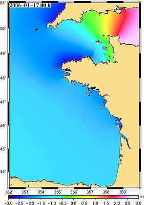
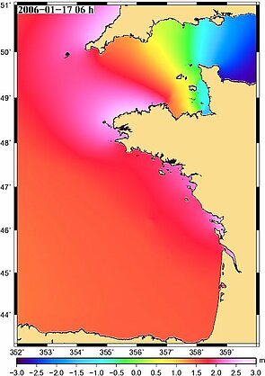
Amplitude of tides from a model along the East Atlantic coasts. The two images are set 6 hours apart (the semi-diurnal tide is the major one there). The corner between the Cotentin peninsula and Brittany shows especially high variations.
See the animation over 10 days (mpeg4, 1.8 MB), one image every hour between January 17, 2006 0h and January 26, 2006 23h (Credits Legos/Cnes/CLS)
Mont St Michel bay, in North-West France, in known for its impressive tides (the highest recorded after the Bay of Fundy in Canada). The whole English Channel, in fact, is a very special area for tides. Tides is one of the oldest ocean phenomena studied and predicted, due to its importance for harbour operations, and the clear link to the Moon phases it exhibits.
Altimetry both benefits from tide models and helps improve them. Altimetry measurements need to be corrected from the tides to set apart other interesting ocean variable phenomena (eddies, El Niño, general ocean circulation...). The tide correction is indeed one of the strongest geophysical correction of altimetry, with an amplitude of several meters in some regions. Global tide models (like GOT, or FES) are commonly used as a reference for tide correction in the altimeter data: those models have now an accuracy of about one centimeter in open ocean. However, significant errors remains in shallow waters and in polar regions, due in particular to sea ice effects. The use of very high resolution data and regional bathymetry among other things allows the development of regional models, with a better accuracy.
On the other side, the height measurements made by altimetry provides significant tidal information at aT global scale (in the open ocean and up to a few kilometers from the coasts) and thus enable to improve tidal models.
See also:
- Data: Auxiliary products
- Image of the Month, Oct 2000: Sun and Moon shape tides on Earth
- Applications: Ocean/Tides
News
 Archives .
- Aviso Newsletter .
- Search.
- Front-page news.
- Image of the month .
- 2026 .
- 2025 .
- 2024 .
- 2023 .
- 2022 .
- 2021 .
- 2020 .
- 2019 .
- 2018 .
- 2017 .
- 2016 .
- 2015 .
- 2014 .
- 2013 .
- 2012 .
- 2011 .
- 2010 .
- Dec. 2010: An island "seen" by altimeter.
- Nov. 2010: Mixing Argo and altimetry to estimate salt.
- Sep. 2010: ASAR vs altimetry South of Africa.
- Oct. 2010: Envisat measures up Antarctica.
- Aug. 2010: Altimetry helps search for a wreck.
- July 2010: North Atlantic Tides.
- June 2010: Penguins at large.
- May 2010: Finer currents.
- Apr. 2010: Drought and flood in the Amazon basin.
- Mar. 2010: Eddies in the Gulf of Alaska.
- Feb. 2010: Arctic sea ice shrinks and thins.
- Jan. 2010: Surface mirrors the deep.
- 2009 .
- 2008 .
- 2007 .
- 2006 .
- 2005 .
- 2004 .
- 2003 .
- 2002 .
- 2001 .
- 2000 .
- 1999 .
- 1998 .
- Operational news and status .