


ASAR vs altimetry South of Africa
Image of the Month - September 2010
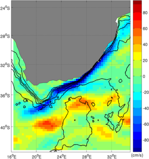
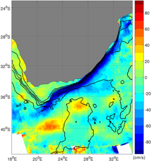
Mean radial velocity of the Agulhas current by altimetry (left, Mean Dynamic Topography) and by ASAR on Envisat (right, 2007-2009 mean). With the new Mean Dynamic topography (MDT_CNES_CLS09), both are very close, with a strong current jet following the 1000 m isobath (200, 500, 1000, 2000 and 4000 m isobaths plotted). (Credits Cape Town University/Nersc/CLS/Ifremer)
The Agulhas current is one of the most powerful currents of Earth's oceans, often studied with several means of observations (see Images of the Month April 2008: Diving in an eddy, or July 2000: Where currents meet). This current is strongly steared by topography, following the 1000 m isobath. It can be seen on altimetry maps, but, since it is the main (and in part steady) flow of the current, this relies on precise knowledge of the mean dynamic topography. From these altimetry topography, the current velocity can be estimated.
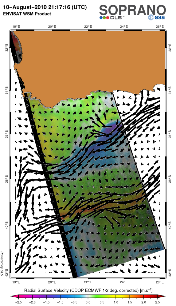
Synthetic Aperture Radar is another technique entirely. The Envisat ASAR instrument enables to estimate mean radial velocity from the measured Doppler shift anomaly, and thus provides a mean to assess the strength and variability of the surface current and upper layer dynamics. In particular where the current lies close to the coast, altimetry measurements are somehow limited and the geoid is not properly resolved. However, SAR acquisitions are programmed and thus mostly not repetitive like altimetry (thus providing repeat global coverage). But at selected ocean sites, such as for the Agulhas Current regime, repeat acquisitions are ensured.
Comparisons between the two techniques in open ocean show very good agreement. It must be noted that the new Mean Dynamic Topography distributed by Aviso (MDT_CNES-CLS09), based on integrated use of altimetry, surface drifters, Argo floats and GRACE-based geoid, significantly improves previous geostrophic current estimates in the Agulhas Current, and thus the agreement.
These two distinct satellite-based observation techniques have their strengths and limitations. In combination, on the other hand, they can be largely overcome, leading to more accurate retrieval methods and products. In this context the Sentinel-1 C-band SAR secures the continuity of the Doppler shift anomaly method, while Saral, Sentinel 3 and Jason-3 will ensure altimetry continuity.
See also:
- Data: Auxiliary products -- Mean Dynamic Topography
- Applications: Ocean large-scale circulation
Other websites on this subject:
- Soprano web site (SAR products on ocean)
- The Agulhas current
References
- M. J. Rouault, A. Mouche, F. Collard, J.A. Johannessen and B. Chapron, Mapping the Agulhas Current from space: an assessment of ASAR surface current velocities, Journal of Geophysical Research (in press), 2010
- This work is supported by ESA through the study contract no. 18709/05/I-LG
News
 Archives .
- Aviso Newsletter .
- Search.
- Front-page news.
- Image of the month .
- 2026 .
- 2025 .
- 2024 .
- 2023 .
- 2022 .
- 2021 .
- 2020 .
- 2019 .
- 2018 .
- 2017 .
- 2016 .
- 2015 .
- 2014 .
- 2013 .
- 2012 .
- 2011 .
- 2010 .
- Dec. 2010: An island "seen" by altimeter.
- Nov. 2010: Mixing Argo and altimetry to estimate salt.
- Sep. 2010: ASAR vs altimetry South of Africa.
- Oct. 2010: Envisat measures up Antarctica.
- Aug. 2010: Altimetry helps search for a wreck.
- July 2010: North Atlantic Tides.
- June 2010: Penguins at large.
- May 2010: Finer currents.
- Apr. 2010: Drought and flood in the Amazon basin.
- Mar. 2010: Eddies in the Gulf of Alaska.
- Feb. 2010: Arctic sea ice shrinks and thins.
- Jan. 2010: Surface mirrors the deep.
- 2009 .
- 2008 .
- 2007 .
- 2006 .
- 2005 .
- 2004 .
- 2003 .
- 2002 .
- 2001 .
- 2000 .
- 1999 .
- 1998 .
- Operational news and status .