


Assimilating TOPEX/POSEIDON data into a numerical model of North Atlantic ocean circulation
J. Verron, E. Brown, E. Blayo and J. M. Molines (IMG/LEGI, France)
TOPEX/POSEIDON altimeter observations provide high-quality information, previously unequalled, for determining the ocean circulation.
However, satellite altimetry has two inherent "structural" obstacles to learning more about the ocean:
- the altimeter observes only the ocean surface,
- it samples the ocean signal rather drastically in space and time.
Data assimilation provides a means of extracting more from the observations by linking them to other types of information, e.g. theoretical and physical laws, numerical models, other observations, etc. In principle, this approach provides a rational basis for extrapolating toward a 3D view of the ocean from a single surface observation and mapping non-observed space-time scales. But for practical large-scale applications, the cumbersome methodology dictates compromises on performance, at least for now. However, even with these constraints, assimilation is a means of extracting much more than surface information from the altimeter observations.
This is the approach to TOPEX/ POSEIDON we have developed in Grenoble, assimilating the data into a high-resolution horizontal (1/6° x 1/6°) numerical prognostic model of the North Atlantic etween 20°N and 60°N.
The aim is to map the 4D content (3D + time) of the ocean circulation during the TOPEX/ POSEIDON observation period, to validate the model forecasts where possible, and eventually derive as much oceanographic information as possible.
The variable components, i.e. residuals, of the TOPEX/POSEIDON altimeter observations can be assimilated into the IMG numerical model in the North Atlantic between 20°N and 60°N. This quasigeostrophic model currently has four layers, and takes account of the actual coastlines and sea floor bathymetry. The ocean circulation is forced by the curl of the wind stress from the Hellerman and Rosenstein data (1983). Newtonian relaxation is used as an assimilation technique to introduce sea surface dynamic topography as a constraint on the model.
This assimilation is done sequentially along the satellite tracks, i.e. when there are observations.
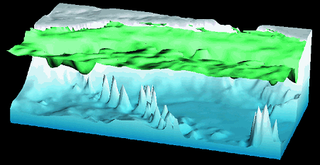
Figure 1 is an instantaneous map of the streamfunction streamlines (parallel to the instantaneous velocity vectors) as predicted from the surface model in assimilation mode on October 23, 1992.
The seafloor bathymetry is also indicated by color coding on the streamline.
Detailed diagnostic analyses have been developed to highlight the resulting flow properties. But as we have few independent observations, full validation is difficult. However, the validations that have been done, especially on the currentmeter and Lagrangian float data, are extremely positive in terms of the climatological behavior of the results.
Validation for the TOPEX/ POSEIDON observation period is clearly even more difficult given the inadequate observation data base.
One of the most interesting results of our simulations concerns the mapping of deep circulation from surface altimeter data only. In the deeper layers, the model predicts instantaneous and mean transport, and more generally has statistical properties that very closely match what we know of the North Atlantic. Energy levels in the North-East Atlantic basin are generally predicted less accurately than in the west, but are still within the expected orders of magnitude. For more details, see Blayo et al. [1993].
Figure 2 illustrates a noticeable effect of submarine topography on circulation control. Observe the 120 cm2/s2 turbulent kinetic energy iso-curve in the North-west Atlantic, close to the New England seamount chain. This shows the trapping of turbulent energy by seamounts since the kinetic energy dome penetrates further up. It also shows that energy weakens markedly immediately below the chain.
Although our work has obvious limits, such as the simplicity of the assimilation method and the quasigeostrophic formulation of the numerical model, it still gives an idea of how an ocean model could be operationally implemented in prognostic mode for real-time integration of the available data. Somewhat unexpectedly, given the above limitations, the purely oceanographic results of the analyses so far seem to be of remarkable quality. Despite the relatively simple tools used, this is a major operation as regards the computing, the hardware needed, the volumes of information involved and use of the oceanographic results. Our results are available to anyone interested.
References :
- Blayo E., J. Verron and J.M. Molines, 1993. Assimilation of TOPEX/POSEIDON altimeter data into a circulation model of the North Atlantic. Accepted for publication in the Journal of Geophysical Research.
News
 Archives .
- Aviso Newsletter .
- Newsletter 1 .
- Newsletter 2 .
- Newsletter 3 .
- The new challenge.
- Validation results.
- T/P sea-state bias.
- T/P and the wind.
- T/P tidal solutions.
- New data set for tides.
- El Niño and T/P.
- T/P data.
- T/P contribution to inverse modeling.
- Assimilating T/P data into a numerical model.
- Operational assimilation of T/P and ERS-1 data.
- Outstandingly accurate mean sea level.
- T/P observes wave enhancement in the Agulhas current.
- Toward a homogeneous ERS - T/P data set.
- Newsletter 4 .
- Newsletter 5 .
- Newsletter 6.
- Newsletter 7 .
- Newsletter 8.
- Newsletter 9.
- Newsletter 10.
- Search.
- Front-page news.
- Image of the month .
- Operational news and status .