


TOPEX/POSEIDON contribution to inverse modeling of the North Atlantic ocean circulation
H. Mercier (LPO/Ifremer, France); P.Y. Le Traon (CLS, France)
The 1990s are seeing a major effort to observe the oceans under the World Ocean Circulation Experiment (WOCE) program.
Much of the data is being returned as in situ observations of the world's oceans and by the TOPEX/POSEIDON satellite.
The oceans play a key role in the climatic balance of our planet, and we hope to learn enough about the ocean and the dynamic balances that regulate it to:
- validate realistic numerical models,
- define a routine observation strategy to reveal any climatic changes.
To reach these goals we will need sophisticated analysis tools for digesting and synthesizing the data. One of the first tasks will be to gather all the data into inverse models so that we can report on the state of the circulation, deduce the dynamic advection/diffusion equilibria, and measure major quantities such as meridional heat transport. The circulation estimates will serve as initial input to global prognostic models.
The Laboratoire de Physique de l'Océan (LPO) has developed an inverse model to achieve these goals. It is presently being used in studies of general circulation in the North Atlantic between 20° and 50°N. The circulation was initially estimated using data from historical hydrographic stations, surface and deep float tracks, and estimates of wind stress at the air-sea interface, all combined with the stationary geostrophic dynamics (Mercier et al. 1993). The study showed that hydrographic measurements providing only geostrophic vertical current shear can be usefully complemented by direct measurements of absolute current by Lagrangian floats, particularly for determining the deep circulation.
It has long been recognized (e.g. Wunsch and Gaposchkin, 1980) that satellite altimetry should make it possible to constrain inverse models of the general circulation:
it is potentially capable of determining sea surface height differences relative to the geoid accurately enough to provide estimates of the absolute geostrophic currents at the ocean surface. However, this is a tricky task, and work on Geosat data by Martel and Wunsch (1993) led to the conclusion that height estimates relative to altimetry-derived geoids were incompatible. The outstanding accuracy of TOPEX/POSEIDON, especially orbital, and the progress in geoid estimation encourage us to believe that height relative to the geoid will now be determined accurately enough at basin scales to improve our results.
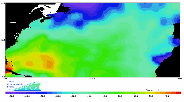
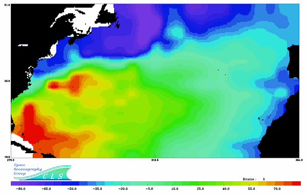
We calculated mean height relative to the geoid with a resolution of 4° in latitude by 5° longitude, using a year of TOPEX/POSEIDON data and the OSU91a geoid (figure 1). The spatial resolution is limited by the geoid error budget, which increases strongly with resolution. For the chosen resolution, the error is around 15 cm. We then successfully merged this information with in situ data in our inverse model of the North Atlantic, determining height to within around 6 cm. This is shown on Figure 2, depicting the main features of the North Atlantic circulation.
This first study encourages an extension of the investigation area to the whole Atlantic, for which the large-scale altimeter constraint will be particularly suitable. The model will also be able to accommodate seasonal and interannual variations in circulation, which TOPEX/ POSEIDON very accurately measures.
References :
- Martel F., and C. Wunsch, 1993. Combined inversion of hydrography, current meter data and altimeter elevations for the North Atlantic circulation, Manuscripta Geodetica, 18, 219-226.
- Mercier, H., M. Ollitrault and P.Y. Le Traon, 1993. An inverse model of the North Atlantic general circulation using Lagrangian float data, J. Phys. Ocean., 23, 689 -715.
- Wunsch, C., and E.M. Gaposchkin, 1980. On using satellite altimetry to determine the general circulation of the oceans with application to geoid improvement, Rev. of Geophys. and Space Phys. , 18, 725-745.
News
 Archives .
- Aviso Newsletter .
- Newsletter 1 .
- Newsletter 2 .
- Newsletter 3 .
- The new challenge.
- Validation results.
- T/P sea-state bias.
- T/P and the wind.
- T/P tidal solutions.
- New data set for tides.
- El Niño and T/P.
- T/P data.
- T/P contribution to inverse modeling.
- Assimilating T/P data into a numerical model.
- Operational assimilation of T/P and ERS-1 data.
- Outstandingly accurate mean sea level.
- T/P observes wave enhancement in the Agulhas current.
- Toward a homogeneous ERS - T/P data set.
- Newsletter 4 .
- Newsletter 5 .
- Newsletter 6.
- Newsletter 7 .
- Newsletter 8.
- Newsletter 9.
- Newsletter 10.
- Search.
- Front-page news.
- Image of the month .
- Operational news and status .