


Outstandingly accurate mean sea level
J.F. Minster (UMR39/GRGS, France)
The TOPEX/POSEIDON satellite estimates mean sea level every ten days.
This article discusses the estimates for cycles 3 (October 1992) through 52 (February 1994) relative to the mean of the first year of observations.
We used data from both altimeters, corrected for a relative bias of 16 cm, based on the "CNES" orbit, the Gaspar et al. sea-state correction bias and the Cartwright and Ray tide model as enhanced by Eanes from T/P data.
At global scale, the ocean must conserve its mass and cannot therefore be sensitive to atmospheric pressure. Figure 1 shows what would we could obtain without an inverse barometer correction. The formal error in each estimate is on the order of 0.2 cm, taking account of errors (and their spatial correlations) currently acceptable for the orbit, measurements and geophysical corrections. The standard deviation of sea level values is 0.8 cm, an outstanding result. In fact the values are not spread like noise: successive values are consistent to within 0.4 cm on average, close to the formal error. The spread of the points suggests a small seasonal signal, of 0.6 cm amplitude, with fluctuations whose period is around 50 days and amplitude around 0.5 cm.
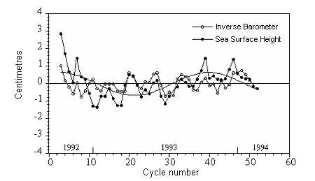
These very small variations may be due to measurement errors. However, it can be shown that the seasonal signal does not represent the seasonal variation resulting from Antarctic sea ice, and that the fluctuations are not due to ocean mesoscale circulation. Similarly, the signals with and without coastal areas are the same. Only 30% of the signal variance is explainable by apparent periods in the ocean tides, so that the fluctuations cannot be due to tide correction errors only, or to correlated orbital errors. The fluctuations are also considerably stronger than the differences between the two wet troposphere corrections or the two ionospheric corrections; in fact they are completely uncorrelated.
There is evidence that some of the variation may be real. An order-of-magnitude calculation shows it may be due to ocean mass variations. However, as regards the apparent seasonal signal, it appears that:
- sea level was higher across the North Atlantic in northern fall 1992 than northern fall 1993,
- the ENSO event reduced mean sea level by 1 cm across the tropical belt in January 1993,
- in 1993 there were small phase differences on the order of a month in the seasonal trend in sea level in each hemisphere, due mainly to variations in steric height.
There are many real fluctuations in the atmosphere and geophysical parameters, with periods on the order of 50 days. Fluctuations in the ocean are therefore only to be expected. The figure shows that the apparent fluctuations in the ocean are strongly correlated with those in atmospheric pressure. What's difficult to understand is why the global ocean undergoes such pressure fluctuations. One possibility is that satellite sampling partly shifts the higher-frequency fluctuations in the atmosphere (and in sea level) toward apparent periods on the order of 50 to 70 days.
In any case, the orbitography people haven't said they can deliver sub-centimeter accuracy orbits yet! It's worth noting that NASA and CNES orbits averaged over 10 days differ constantly (1.0 ± 0.13 cm) from one cycle to another. Unfortunately, we probably can't consider the orbits independent. There may even be actual orbital fluctuations with periods on the order of 50 days, related, for example, to atmospheric fluctuations or solar winds, and these have been poorly modeled.
The surprising thing is that we can actually talk about millimeter-type variations. The annual mean could be even better, so that secular drift in sea level, on the order of 1.5 mm a year, could be detectable in a few years by T/P and its follow-ons, providing the signal is not hidden by interannual fluctuations or errors that we still know nothing about.
News
 Archives .
- Aviso Newsletter .
- Newsletter 1 .
- Newsletter 2 .
- Newsletter 3 .
- The new challenge.
- Validation results.
- T/P sea-state bias.
- T/P and the wind.
- T/P tidal solutions.
- New data set for tides.
- El Niño and T/P.
- T/P data.
- T/P contribution to inverse modeling.
- Assimilating T/P data into a numerical model.
- Operational assimilation of T/P and ERS-1 data.
- Outstandingly accurate mean sea level.
- T/P observes wave enhancement in the Agulhas current.
- Toward a homogeneous ERS - T/P data set.
- Newsletter 4 .
- Newsletter 5 .
- Newsletter 6.
- Newsletter 7 .
- Newsletter 8.
- Newsletter 9.
- Newsletter 10.
- Search.
- Front-page news.
- Image of the month .
- Operational news and status .