


The TOPEX/POSEIDON data
C. Wunsch (MIT, USA)
The TOPEX/POSEIDON mission, launched in August 1992 and having so far produced about 18 months of data, was designed to be a central element of the World Ocean Circulation Experiment (WOCE).
It has been clear since discussions first began in the early 1970's that altimetry was the only known technology capable of producing true global coverage of the ocean, with sampling rates and accuracies adequate to define the ocean circulation as a whole.
Given the importance of altimetry to WOCE, and the very long time between design and launch, it is highly satisfying to report this spacecraft is working at levels of accuracy and precision considerably exceeding the original design specifications. The results vindicate the work of the small group which set out in the late 1970's to obtain high accuracy global altimetric observations- at a time when the technology actually available was one-two orders of magnitude too crude to be useful.
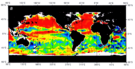
A large number of preliminary products are now available from the TOPEX/POSEIDON data. Figure 1 shows a 10-day "snapshot" of the absolute ocean circulation, relative to an estimate of the geoid due to Nerem et al. [1994; JGM-2]. All of the known major features of the ocean circulation are apparent: the subpolar and subtropical gyres of all oceans, the Circumpolar Current, the lower average Atlantic elevation, etc.
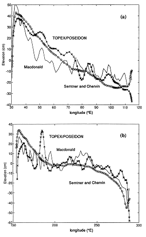
The major residual problems here concern the geoid accuracy, and are the subject of a very intensive effort to remove them. To give some sense of the accuracy which has been achieved, figure 2 shows the absolute elevation along two lines: one in the Indian Ocean at 32° S [Toole and Warren, 1992] and one at 28° S [Stommel et al., 1973]. Three curves are shown for each line: the annual average from TOPEX/POSEIDON relative to the Marsh et al. geoid; the estimate of absolute sea level from preliminary results of an inverse model of the global circulation based upon the hydrography alone [Macdonald, 1994]; and the elevation from a three-year mean of the 1/4° resolution version of the model of Semtner and Chervin [1992]. Although the space/time averaging is not yet wholly consistent, we see that these three estimates, made from extremely different methods, are generally within 10 cm of each other over entire ocean basins- a remarkable sign of progress in understanding of the ocean circulation in the past decade.
Time dependent oceanic motions are measurable almost independent of any lingering geoid errors. Figure 3 displays seasonal anomalies relative to the one-year average circulation. One sees quite clearly the gross seasonal oscillation in sea level: the northern hemisphere is high in the northern hemisphere autumn, and reaches a minimum in northern hemisphere spring. Much of this signal is steric, but clear dynamical effects are visible, especially in the tropics. Prior to TOPEX/POSEIDON, the best such maps were constructed from the sparse and fragmentary global sea level network.
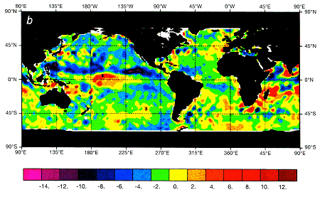
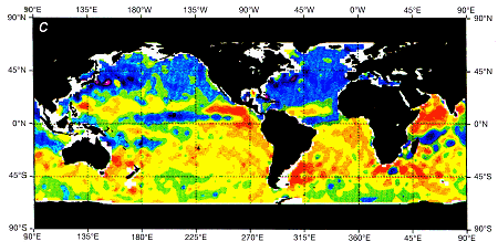
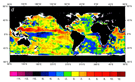
3 - Annual march of sea level anomaly, shown as seasonal average minus the annual mean, showing
(a) autumn 1992,
(b) winter 1992-93,
(c) spring 1993, and
(d) summer, 1993. Hemispheric asymmetry and dynamical effects are apparent.
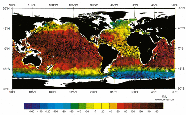
The rms sea level variability obtained from TOPEX/POSEIDON data over one year was also calculated. Although earlier missions had produced similar results, these are sharper and more accurate than any previously obtained. Much WOCE activity will be directed at comparisons between these results and mooring and float data, as well as the eddy fields generated in the present generation of high resolution general circulation models.
In a very real sense, TOPEX/ POSEIDON is an astonishing technical accomplishment: we are measuring the sea surface topography to point-wise accuracies of a few centimeters from 1300 km in space. The engineering and scientific visions of the 1980s have been fully vindicated. The few results shown here are still preliminary but show that for the first time, oceanographers have a true global observing system. For WOCE and for oceanographers generally, there are now several immediate priorities:
1/ To produce the most accurate possible data sets. Point-wise absolute accuracies near 1 cm appear possible.
2/ To sustain the mission accuracy and data flow over the full hoped-for lifetime of 5+ years.
3/ To attempt to provide successor missions - will oceanographers be content in the future if observations like those from TOPEX/POSEIDON cease to be available for understanding of the ocean circulation and climate change?
4/ To induce space agencies to fly one of the several possible gravity missions. Such a mission would greatly reduce the final uncertainty of the absolute circulation from TOPEX/POSEIDON.
References:
- Macdonald, A., 1994. PhD thesis, MIT-WHOI, in preparation.
- Nerem, R. S., and 19 others, 1994. Gravity model development for TOPEX/POSEIDON: Joint gravity models 1 and 2. J. Geophys. Res., submitted.
- Stommel, H., E. D. Stroup, J. L. Reid, and B. A. Warren, 1973. Transpacific hydrographic sections at Lats. 43° S and 28° S: the SCORPIO expedition-I. Preface Deep-Sea Res., 20 1-7.
- Toole, J. M. and B. A. Warren 1992. A hydrographic section across the subtropical Indian Ocean. Deep-sea Res., 40, 1973-2020.
News
 Archives .
- Aviso Newsletter .
- Newsletter 1 .
- Newsletter 2 .
- Newsletter 3 .
- The new challenge.
- Validation results.
- T/P sea-state bias.
- T/P and the wind.
- T/P tidal solutions.
- New data set for tides.
- El Niño and T/P.
- T/P data.
- T/P contribution to inverse modeling.
- Assimilating T/P data into a numerical model.
- Operational assimilation of T/P and ERS-1 data.
- Outstandingly accurate mean sea level.
- T/P observes wave enhancement in the Agulhas current.
- Toward a homogeneous ERS - T/P data set.
- Newsletter 4 .
- Newsletter 5 .
- Newsletter 6.
- Newsletter 7 .
- Newsletter 8.
- Newsletter 9.
- Newsletter 10.
- Search.
- Front-page news.
- Image of the month .
- Operational news and status .