


MEAN SEA LEVEL VALIDATION AND ESTIMATION OF ERRORS
When calculating and analyzing the evolution of mean Sea Level (MSL), the question legitimately arises as to whether altimeters are reliable enough to measure a rise in MSL of a few millimeters per year over a period of more than 20 years. There are potentially many sources of errors that could affect the long-term stability of the GMSL record. These errors come from the ageing of intruments for instance, from the uncertainty of their calibration, from the ageing and incidents/maneuvers of the satellite platform, from the orbit calculations, as well as from all the uncertainties associated to the geophysical corrections used to derive the SSH (tides, troposphere, ionosphere, ect). The estimation of the uncertainties of the MSL altimetry data is thus key to be able to validate the accuracy of such climate data record.
UNCERTAINTY ON THE GMSL RISE
Following the approach of Ablain et al. (2019) who consider all potential sources of errors affecting the altimetric system, an updated error budget has been established for the GMSL timeseries up to 2025. Using an Ordinary Least Square (OLS) fit that considers this error budget, the GMSL trend uncertainty (i.e., the mean rise uncertainty) is estimated at 0.5 mm/yr over the whole altimetry era (1999-2025) at the 90% confidence level.
Comparison with in-situ measurements
Another approach for describing the GMSL error consists in comparing the sea level data with in situ data such as tide gauges or ARGO data (temperature and salinity profiles) (Ablain et al., 2009 (a), (b)). The stability of the altimetry system can thus be assessed by detecting drifts or leaps in the GMSL (SALP annual GMSL report 2017).
Comparison to tide gauges
The method to compare altimeter and tide gauges data (noted Alti-TG hereafter) is based on the main following steps:
- The along-track altimeter data are averaged on 360x180 global grids (1°x1° cells). One grid is computed per mission cycle, except for comparisons to the PSMSL tide gauge network, where monthly grids are used.
- In a 300 km radius around each tide gauge, the best correlated grid element is chosen and a GMSL difference time series (Altimeter GMSL - Tide gauge GMSL) is computed.
- A mean global Alti-TG time series is computed from Alti-TG time series. The trend difference is computed from this global time series, which represents the estimated altimeter GMSL drift.
- Vertical Land Motion (VLM) correction: each trend difference is corrected for Glaciar Isostatic Ajustment (GIA) induced VLM, using Pr. Peltier’s ICE-5G(VM2) model (see Peltier 2004). Due to insufficient GPS data at the tide gauge locations over the whole GLOSS-CLIVAR or PSMSL networks, no correction is applied for the other VLM contributions.
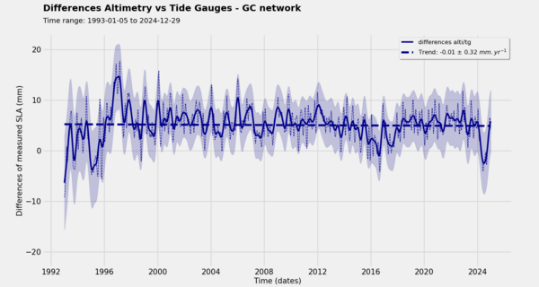
The GMSL drifts and associated uncertainties (at the 90% confidence level), based on comparisons with GLOSS-CLIVAR and PSMSL data, are shown for each altimeter on the figure below. For most missions, no significant drift can be detected. Most notably, the drift for the reference GMSL time series provided on the AVISO website is estimated between -0.33 mm/yr and +0.31 mm/yr at the 90% confidence level, thus is not considered as significant.
If we take a closer loot at this curve by examining each mission individually, we can derive the relative drift and their associated uncertainties (at the 90% confidence level) between the altimeters and the GLOSS/Clivar tide gauge network:
- Topex (A&B): −0.64 ± 1.25 mm/yr
- Jason-1: +0.13 ± 1.13 mm/yr
- Jason-2: +0.63 ± 0.92 mm/yr
- Jason-3: −0.57 ± 1.31 mm/yr
- Sentinel-6 MF (up to 2023-12-31): +0.77 ± 3.95 mm/yr
The anomaly observed in 2024 in the comparison between Sentinel-6 MF and tide gauges may be due to a reduced amount of available data in the tide gauge network. Additionally, the uncertainty associated with the Sentinel-6 MF period is significantly higher than that of the other altimeters, essentially because the time series is much shorter.
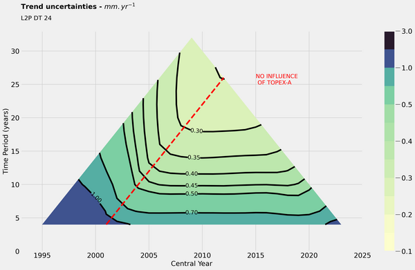
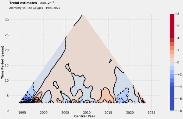
Finally, this last figure illustrates the relative drift between altimetry and tide gauges data across various time periods of different lengths. The x-axis represents the central date of each studied period, while the y-axis indicates the duration of the period.
Local errors in MSL slopes
With respect to local errors of MSL slopes, the same statistical approach was applied in order to describe locally the different sources of uncertainty in altimetry data [Ablain et al., 2010]. This work revealed the strong local impact of inter-annual variability since it accounts for 80% of the formal adjustment error, which demonstrates that the periods of altimetry data are still too short to estimate slopes locally. The residual errors (20%) due to errors in the altimetry system vary essentially according to latitude between 1 and 2 mm/year due to uncertainties in orbit determination and correction for the wet troposphere respectively at high latitudes and in the tropical band. In this case as well, the description of local errors should be refined to take into account in particular the impact of variable gravity fields for the orbit calculation [Cerri et al., 2010] or again uncertainty in zones close to coasts or to ice due to the degradation of the altimetry measurement.
Recent work has been published by Prandi et al. 2021 that described the state-of-the-art regional MSL uncertainties.
References
- (a) Ablain, M., Cazenave, A., Valladeau, G., Guinehut, S., 2009. A new assessment of the error budget of global mean sea level rate estimated by satellite altimetry over 1993-2008. Ocean Science, 5(2), 193-201. DOI: 10.5194/os-5-193-2009
- (b) Ablain M., 2009. Quality assessment of tide gauge and altimeter measurements through SSH comparisons. Oral presentation in OSTST, Seattle 2009.
- Ablain M., 2010. Quality assessment of tide gauge and altimeter measurements through SSH comparisons. Oral presentation in ESA Symposium, Bergen 2010.
- Ablain, M., Philipps, S., Urvoy, M., Tran, N., Picot, N., 2012. Detection of long-term instabilities on altimeter backscatter coefficient thanks to wind speed data comparisons from altimeters and models. Marine Geodesy, 35(sup1), 258-275. DOI: 10.1080/01490419.2012.718675
- Ablain, M., Legeais, J. F., Prandi, P., Marcos, M., Fenoglio-Marc, L., Dieng, H. B., Benveniste, J., Cazenave, A., 2017. Satellite altimetry-based sea level at global and regional scales. In: Cazenave A., Champollion N., Paul F., Benveniste J. (eds) Integrative Study of the Mean Sea Level and Its Components. Space Sciences Series of ISSI, vol 58. Springer, Cham. DOI: 10.1007/978-3-319-56490-6_2
- Ablain M., R. Jugier, N. Picot., 2018. Estimation of any Altimeter Mean Seal Level Drifts between 1993 and 2017 by Comparison with Tide-gauges Measurements. Presented at International Review Workshop on Satellite Altimetry Cal/Val Activities and Applications 2018.
- Beckley, B. D., Callahan, P. S., Hancock, D. W., Mitchum, G. T., Ray, R. D., 2017. On the "Cal-Mode" Correction to TOPEX Satellite Altimetry and Its Effect on the Global Mean Sea Level Time Series. Journal of Geophysical Research: Oceans, 122(11), 8371-8384. DOI: 10.1002/2017JC013090
- Cerri L., Berthias J.P., Bertiger W., Haines B., Lemoine F.G., Mercier F., Ries J.C., Willis P., Zelensky N.P., Ziebart M., 2010. Precision Orbit Determination Standards for the Jason Series of Altimeter Missions. Marine Geodesy 2010.
- Chen, X., Zhang, X., Church, J. A., Watson, C. S., King, M. A., Monselesan, D., Legresy, B., Harig, C., 2017. The increasing rate of global mean sea-level rise during 1993–2014. Nature Climate Change, 7, 492-495. DOI: 10.1038/nclimate3325
- Couhert, A., Cerri, L., Legeais, J. F., Ablain, M., Zelensky, N. P., Haines, B. J., Lemoine, F.G., Bertiger, W.I., Desai, S.D., Otten, M., 2015. Towards the 1 mm/y stability of the radial orbit error at regional scales. Advances in Space Research, 55(1), 2-23. DOI: 10.1016/j.asr.2014.06.041
- Dieng, H. B., Cazenave, A., Meyssignac, B., Ablain, M., 2017. New estimate of the current rate of sea level rise from a sea level budget approach. Geophysical Research Letters, 44(8), 3744-3751. DOI: 10.1002/2017GL073308
- Escudier, P., Couhert, A., Mercier, F., Mallet, A., Thibaut, P., Tran, N., Amarouche, L., Picard, B., Carrère, L., Dibarboure, G., Ablain, M., Richard, J., Steunou, N., Dubois, P., Rio, M. H., and Dorandeu, J., 2017. Satellite radar altimetry: principle, geophysical correction and orbit, accuracy and precision, in: Satellite Altimetry Over Oceans and Land Surfaces, edited by: Stammer, D. and Cazenave, A., CRC Press, Taylor Francis, Boca Raton
- Legeais, J.-F., Ablain, M., Zawadzki, L., Zuo, H., Johannessen, J. A., Scharffenberg, M. G., Fenoglio-Marc, L., Fernandes, M. J., Andersen, O. B., Rudenko, S., Cipollini, P., Quartly, G. D., Passaro, M., Cazenave, A., and Benveniste, J., 2018. An improved and homogeneous altimeter sea level record from the ESA Climate Change Initiative. Earth System Science Data, 10, 281-301. DOI: 10.5194/essd-10-281-2018
- SALP annual GMSL report 2017. Validation of altimeter data by comparison with tide gauges measurements and with in-situ T/S ARGO profiles
- Valladeau, G., Legeais, J. F., Ablain, M., Guinehut, S., Picot, N., 2012. Comparing altimetry with tide gauges and Argo profiling floats for data quality assessment and mean sea level studies. Marine Geodesy, 35(sup1), 42-60. DOI: 10.1080/01490419.2012.718226
- Watson, C. S., White, N. J., Church, J. A., King, M. A., Burgette, R. J., Legresy, B., 2015. Unabated global mean sea-level rise over the satellite altimeter era. Nature Climate Change, 5(6), 565. DOI: 10.1038/nclimate2635
- Zawadzki, L., Ablain, M., 2016. Accuracy of the mean sea level continuous record with future altimetric missions: Jason-3 vs. Sentinel-3a. Ocean Science, 12(1), 9-18. DOI: 10.5194/osd-12-1511-2015
Data
- Products guide.
 Products .
- Sea surface height products .
- Value-added products .
- Wind/wave products .
- Auxiliary products .
- Ice products .
- Ocean indicators products .
- Ocean data challenges .
- Tide Gauges products.
- Data access .
- Product information .
- CALVAL .