


Salinity gets finer with altimetry
Image of the Month - January 2013
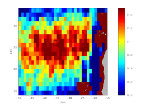
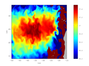
Left: Initial low-resolution SMOS gridded sea surface salinity (SSS) for August 15, 2012. Right: High resolution SSS field obtained by merging SMOS SSS with AVISO real-time altimetry; the presence of a (sub-)mesoscale front of the maximum SSS in that region is clear in the second map. These experimental (sub-)mesoscale SSS maps were produced in real time to support the sampling strategy of the STRASSE campaign. The black square indicates the area of study identified for the field campaign.(Credits LOcean/AMU)
Salinity is one of the factors driving ocean circulation. For a long time, it was measured only in situ, thus leading to a somehow sparse sampling in time and/or areas. Now, since 3 years (SMOS mission, ESA; 1 year and a half for Aquarius, NASA), satellite measurements of salinity have been available. However, those need to be calibrated, and need supplementary information to be interpreted.
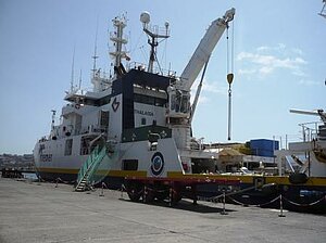
Thus an international programme, SPURS, including several field campaign has been launched. In particular, the French STRASSE cruise took place from August 16 to September 13, 2012 on board the RV Thalassa (French IFREMER and Spanish IEO agencies) with the middle of the North Atlantic subtropical gyre in focus, where salinity is at its highest (with low precipitations, high evaporation).
During this campaign a key aspect for the project was to identify a suitable region within the Sea Surface Salinity (SSS) maximum region for the in situ investigation. SMOS gridded Sea Surface Salinity provided information on the large scale spatial distribution of SSS for the days preceding the beginning of the campaign. To include the effects of the mesoscale dynamics on the spatial distribution of salinity, the satellite salinity were merged in real-time using surface geostrophic velocities derived from altimetry. This allowed to obtain a higher-resolution SSS map, from which it was possible to successfully identify the best area (35-36°W, 25.5-26.5°N) for the STRASSE field campaign. Preliminary results from in situ observations confirm the high-resolution SSS map thus obtained. This pilot study is an example of how altimetry and Lagrangian tools (filament computation) may serve in the future for integrating novel satellite data (like SSS) and in situ observations.
See also:
- Image of the Month, Oct. 2008: Thread-like structures extracted from altimetry
- Image of the Month, Sep. 2009: Birds track ocean eddies
- Applications: ocean mesoscale circulation
Other websites on this subject:
- SPURS (French side)
- LOcean for the gridded SSS
- Smos, the global success continues, with an animation superimposing the salinity and currents over the Gulf Stream. (Esa website)
References
- J. Boutin, N. Martin, G. Reverdin, X. Yin and F. Gaillard, Sea surface freshening inferred from SMOS and ARGO salinity: Impact of rain, Ocean Sci. Discuss., 9, 3331-3357, doi:10.5194/osd-9-3331-2012, 2012
News
 Archives .
- Aviso Newsletter .
- Search.
- Front-page news.
- Image of the month .
- 2026 .
- 2025 .
- 2024 .
- 2023 .
- 2022 .
- 2021 .
- 2020 .
- 2019 .
- 2018 .
- 2017 .
- 2016 .
- 2015 .
- 2014 .
- 2013 .
- Dec. 2013: Mediterranean tides on the move.
- Nov. 2013: Typhoon Haiyan seen by Saral.
- Oct. 2013: Salt and temperature vs altimetry.
- Sep. 2013: Icebergs on the move.
- Aug. 2013: 20 years of typhoons.
- Jul. 2013: Ob bogs and wetlands.
- Jun. 2013: Is the ground rising or the sea decreasing?.
- May 2013: Drifting buoy.
- Apr. 2013: Surface currents, a pinch of winds with altimetry.
- Mar. 2013: Saral: 6 days old, and already measuring.
- Feb. 2013: Alboran Sea eddies.
- Jan. 2013: Salinity gets finer with altimetry.
- 2012 .
- 2011 .
- 2010 .
- 2009 .
- 2008 .
- 2007 .
- 2006 .
- 2005 .
- 2004 .
- 2003 .
- 2002 .
- 2001 .
- 2000 .
- 1999 .
- 1998 .
- Operational news and status .