


Is the ground rising or the sea decreasing?
Image of the Month - June 2013
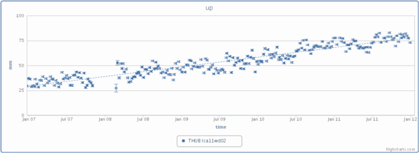
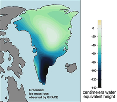
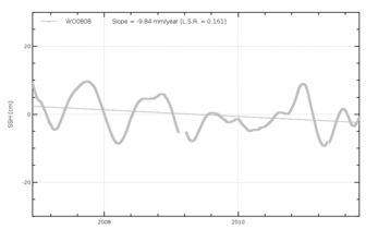
Vertical motion as measured by Doris (up, Credits IDS) for the Thule beacon. Bottom left, ice melt computed from Grace measurements (Credits JPL/University of Colorado) and right tide gauge measurements at the same place (CLS/CNES). The Doris beacon shows a vertical motion up, the tide gauge seems to show the sea level decreasing. GPS measurement at still the same location show the same than Doris. Thule is located at the North-West of Greenland, where ice melt frees the land from weight, thus permitting the land to rise.
Tide gauges have been used to monitor sea level for the past century or so. However, they are anchored on lands, and thus monitor as much the land vertical motions than the sea's. In some cases, however, you can find tide gauges and Doris stations close by. Doris system is the system used to measure altimetry satellites' altitudes. It is also a very precise location system that enables to monitor minute moves of the grounds where the station is built.
Thule, North-West of Greenland, has both Doris and tide gauge. Doris shows an increase of nearly one centimeter per year (+9.73 mm/yr), while the tide gauge shows a decrease of the same order (-9.84 mm/yr). But Doris station measures its own motions (i.e. the shifts of the land where it is built), while the tide gauge measures the sea level variations with respect to the tide gauge itself. Since the tide gauge is on the Earth crust, the tide gauge "motions" are the one of the crust. Thus we can conclude in this case that the land is rising there -- most probably due to the melt of glaciers, that frees the ground from a huge weight as confirmed by the Grace gravimetry satellite results. The GPS station close-by also shows a land rising.
Doris is one of the systems used to better know the solid Earth motions, either vertical like here, but also horizontal (e.g. tectonic plates' motions). Combining its measurements with other techniques enables to better understand our planet.
See also:
- Doris
- Image of the Month, May 2000: Doris sees the seasons weighting on Earth
- Image of the Month, October 2009: Dumont d'Urville movements measured by Doris
- Applications: Other geophysical applications
- Calval: In situ global statistics - Tide gauges
Websites on this subject:
- Doris
- Presentation of Doris (Cnes)
- International Doris Service (IDS)
including interactive Tools to plot Doris locations time series
News
 Archives .
- Aviso Newsletter .
- Search.
- Front-page news.
- Image of the month .
- 2026 .
- 2025 .
- 2024 .
- 2023 .
- 2022 .
- 2021 .
- 2020 .
- 2019 .
- 2018 .
- 2017 .
- 2016 .
- 2015 .
- 2014 .
- 2013 .
- Dec. 2013: Mediterranean tides on the move.
- Nov. 2013: Typhoon Haiyan seen by Saral.
- Oct. 2013: Salt and temperature vs altimetry.
- Sep. 2013: Icebergs on the move.
- Aug. 2013: 20 years of typhoons.
- Jul. 2013: Ob bogs and wetlands.
- Jun. 2013: Is the ground rising or the sea decreasing?.
- May 2013: Drifting buoy.
- Apr. 2013: Surface currents, a pinch of winds with altimetry.
- Mar. 2013: Saral: 6 days old, and already measuring.
- Feb. 2013: Alboran Sea eddies.
- Jan. 2013: Salinity gets finer with altimetry.
- 2012 .
- 2011 .
- 2010 .
- 2009 .
- 2008 .
- 2007 .
- 2006 .
- 2005 .
- 2004 .
- 2003 .
- 2002 .
- 2001 .
- 2000 .
- 1999 .
- 1998 .
- Operational news and status .