


Global ocean dynamic topography, and how it varied
J.F. Minster, C. Brossier & P. Femenias (UMR 39/GRGS, France)
Several PIs have been selected from the UMR39/GRGS laboratory in Toulouse, France.
They are working on one of the most fundamental Topex/Poseidonobjectives: to determine the dynamic topography at the scale of ocean basins.
The quality of the data, even preliminary, is so good that the signal appears even with minimal processing. This concerns both the variation in sea level height obtained by differencing the heights measured between two cycles (see figure 1) and absolute dynamic height above the geoid (figure 2).
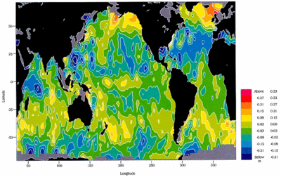
The most prominent signal consists of negative values (-10 cm) in the subtropical gyres of the northern hemisphere and positive values in those of the southern hemisphere. These signals are probably due to seasonal thermal expansion, most marked during spring and fall. The fact that the signals seem to have most impact on sub-tropical gyres is consistent with in situ observations. It may also indicate additional variations related to changes in wind surface stress. Along the Equator in the Pacific, the strong increase in the sea level signal may correspond to a Kelvin wave. Work by the Naval Research Center even suggests a El Niño event.
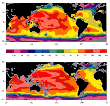
Top: ocean dynamic topography mapped from 10 days of preliminary Topex/Poseidon data.
The orbit is calculated from Doris data. The data was corrected for the usual effects:
- ionosphere, using the Bent model,
- troposphere with pressure calculated using the ECMWF model and atmospheric water vapor deduced from the Topex Microwave Radiometer (TMR) measurements,
- sea state,
- ocean and earth tides.
One of the most recent geoids was interpolated along the satellite track and subtracted. The values were then averaged over 1° boxes and mapped.
The data was not processed in any other way, so the result still includes measurement, orbit and geoid errors. Height variations are clearly due to the major surface currents. For example the Gulf Stream goes around the hump in the Sargasso sea, while the Antarctic Circumpolar Current runs alongside the north-south slope at about 40°S.
Bottom: dynamic topography map derived from a century of hydrographic measurements, assuming zero current velocity everywhere at pressures of 2000 dbar (around 2000 m depth).
The outstanding qualitative agreement between the two maps highlights the extraordinary quality of Topex/Poseidon data, even before all the tuning and more sophisticated data processing had been done. Some of the differences may, in any case, be due to known seasonal or interannual effects. For example, in the tropical Atlantic, the North Equatorial Counter Current is intense in October and absent in spring. This would explain the local maximum in the Topex/Poseidon map (blue at around 10°N), not present on the climatological map.
The objectives of the Topex/Poseidon mission include monitoring this type of information to deduce variations in ocean currents and their interactions with climate variations.