Mobile version

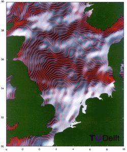
Mean sea surface over the North Sea

Edwin Wisse, Remko Scharroo, Marc Naeije and Karel Wakker (Delft University of Technology, The Netherlands)

A mean sea surface over the North Sea was created by combining all available data from three satellites (Geosat, ERS-1, and Topex/Poseidon): the full Geosat dataset, the first 17 months of ERS-1 (FDPs), and the first ten Topex/Poseidon 10-day cycles (Aviso IGDR-Ms). The radial orbit error was reduced by minimizing crossover residuals in a least squares sense. The data were interpolated to a rectangular grid using objective mapping. The resulting mean sea surface was high-pass filtered.
The surface is illuminated from the northwest to show small-scale details; contours were plotted every 25 centimeters.

Some bottom topography features are visible in the northwestern part of the area.
In this area the mean sea surface shows mainly geological features. Between the Danish and the northern Dutch coast a number of "Graben" can be seen; these are old faults which were later filled with sediment.
The Ringkobing/Fyn High, west of Denmark, is clearly visible.

EnglishFrançais
Rss feedsContactPartnersFAQLexiconLegal noticePersonal Data Protection PolicyMobile
You must enable cookies in your browser preferences to save the modifications
You are using an older version of Internet Explorer, please update to take full advantage of Aviso+ features

Customize the home page

View all widgets
Reduce display
Public profile
User profile

Select/Deselect widgets

Discover AVISO+

Customizable home, reading tools, products search guide, etc.. Discover step by step the features of the new site AVISO+.

Customizable homepage

This home page is composed of blocks called "widgets".

Rearrange the blocks with a "Click & Drop".

Hide a widget with the cross at the top right. Reset or add a widget with the "wrench" icon. The "User" and "Public" profiles offer a predefined organization.

All the modifications are automatically saved as cookies on your machine so as to enable you to have your own specific AVISO+.

Reading tools

Ease your reading by choosing the page background colour (black/white) and/or by modifying the font size.

Browsing menu and breadcrum trail

To ease your browsing through AVISO+, you can use at any time the main banner items with the interactive submenus or use the browsing menu on the left side of the screen (it is open by default). For more readiness of the page contents, you can fold and unfold the browsing menu by clicking on the tab. At any time you can know where you are thanks to the browsing menu or the breadcrum at the top of the page.

Products search guide

The first submenu of the "Data" banner item leads you to a new search form enabling you to find quickier the product that suits your needs. The list of results is updated according to your selection criteria.

AVISO+ Multimedia

The first submenu of the "Multimedia" banner item leads you to AVISO+ collections of images and videos linked to altimetry and its applications. Have a nice visit!