


Otec: Ocean Topography of The English Channel
C. Le Provost, J.M. Molines (Legi/IMG, France)
The main purpose of Otec is to correct Topex/Poseidon measurements for tidal effects, as deduced from local models, and compare the corrected heights from one cycle to the next.
The Otec operation, part of the Aviso/Quick-look project [Le Provost, 1974; Le Provost, 1981; Le Provost, 1983; Le Provost & Fornerino, 1985] uses existing in-depth knowledge of tides in the Channel. In these coastal waters, variability in sea level is mainly due to very strong semi-diurnal tides, with tidal ranges up to 12 m at St. Malo on the French coast during spring tides. The general circulation and the weather have little effect.
From the tide model for the Channel we can forecast the instantaneous level to within 10 cm [Le Provost, 1983].
The along-track differences between cycles represent the cumulative orbital error, propagation corrections and tidal corrections. In the ideal case, with these errors zero, if we assume that the ocean signal contribution is negligible, we would have a perfect overlay of the corrected heights, giving the shape of the geoid along that track.
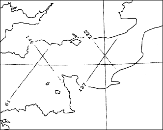
The passes over the Channel are passes 61, 137, 146 and 222 (Figure 1). In this article we refer to pass 61 only, at the western end. The data we used are the simplified files, version 1 IGDR-Ms, distributed as part of the Aviso/Quick-look project.
The corrections applied were: Doris ionospheric, closest dry tropospheric, TMR wet tropospheric, inverse barometer, CNES electromagnetic bias (Ku), earth tide and load effects. We did the calculation several times using different orbits: Cnes, Nasa and a Cnes (Aviso/Quick-look) orbit with 1-cycle-per-revolution and 2-cycles-per-revolution corrections by minimizing the rms values at crossover points.
Figure 2 shows the corrected heights on track 61 for cycles 1 to 9.
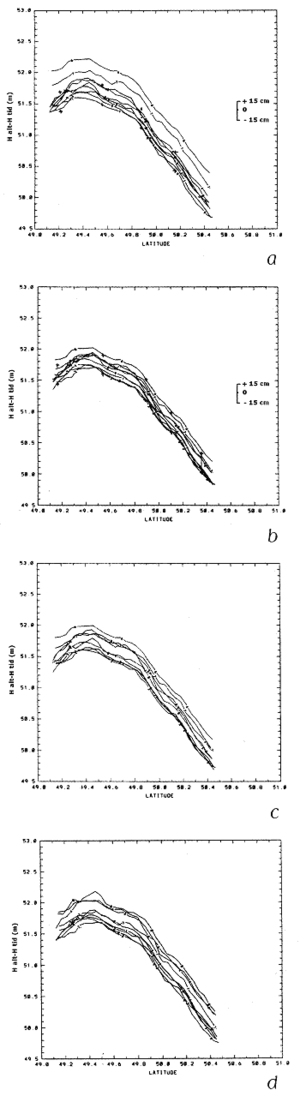
Figure 2a to 2d: Sea surface height for track 61, cycles 1 to 9:
a) Cnes orbit,
b) Cnes orbit with Aviso/Quick-Look orbit correction,
c) Nasa orbit ,
d) Nasa orbit without inverse barometer correction
It turns out that:
- the results from the Nasa orbit are better grouped than those from the Cnes orbit,
- with the 1-cycle-per-revolution and 2-cycles -per-revolution orbital correction, the results of the corrected Cnes orbit are within a range of ±15 cm and therefore provide roughly the same quality as the Nasa orbit, with the exception of cycle 6,
- the inverse barometer correction is useful for grouping the results and we think it is appropriate for the area considered,
- thanks to this experiment we can gauge the final accuracy of the altimeter data distributed in the Aviso IGDR-Ms. The range of ±15 cm, encouraging in itself, should be noticeably reduced when the new orbits being computed at Cnes are ready.
References
- Le Provost, C., 1974: Contribution à l'étude des marées dans les mers littorales. Application à la Manche. Doctoral thesis, Grenoble
- Le Provost, C., 1981: A model for prediction of tidal elevations over the English Channel. Oceanologica Acta, 4, 279-288
- Le Provost, C., 1983: An analysis of SEASAT altimeter measurements over a coastal area: The English Channel. J. Geophys. Res., 88, 1647-1654
- Le Provost, C., M. Fornerino, 1985: Tidal spectroscopy of the English Channel with a numerical model. J. Phys. Oceanogr., 15, 1009-1031.