


First Aviso Quick-looks: looking good
Pierre-Yves Le Traon (CLS, France)
Topex/Poseidon Quick-look activities are now well under way. The data produced by Aviso/Eddie (IGDR-Ms) is being analyzed and validated.
More processing has been done to derive value-added products for scientific users: heights corrected for geophysical corrections and orbital error, residuals relative to a mean or a cycle.
The results of the analyses and some of the Quick-look products are described below.
Aviso/Quick-look includes an initial phase in which the data is checked and geophysical corrections applied (see article by Jacques Stum). The first nine cycles (IGDR-M) have thus been validated.
The usual geophysical corrections have been applied: earth and ocean tides, ionospheric correction via Doris, dry tropospheric correction, wet tropospheric correction deduced from radiometer, electromagnetic bias, and inverse barometer effect. We then estimate the orbital error by minimizing the differences at crossover points over a cycle. This is done systematically to subtract the main 1-cycle-per-revolution and 2-cycles-per-revolution frequencies of the orbital error. We used the preliminary Doris orbit, which is already highly precise but for which "butterfly" effects at one cycle per revolution are easily identified. These effects are easy to correct by minimizing the differences at crossover points. Simplified files of heights corrected for geophysical effects and orbital error are then created for each cycle. Geographical samples of the files were sent to some of the PIs working on Quick-look activities (see articles by Christian Le Provost and Jean-Marc Molines and Pierre Queffeulou).
The sea surface topography variations relative to the mean were calculated from the nine processed cycles (three months). This means interpolating the data for each cycle in a common grid along the tracks, then calculating the difference between the cycle and the mean.
This removes the geoid signal and provides the variation in sea level over the period processed. Geographical samples of the file are available for PIs.
Measurement accuracy
Figure 1 shows the geographical distribution of the rms difference in sea surface height at crossover points during cycle 3. The overall value for rms deviation is just 10 cm, instead of 20 cm before adjusting for orbital error. As the ocean generally changes little over a ten-day cycle, the differences at crossover points provide the upper limit for total system accuracy.
The differences are on the order of 4-6 cm in areas of low ocean variability. Higher values are observed in the western boundary currents and near the coasts where the tide models used are not precise enough. Minimization also absorbs the bias between Topex and Poseidon. This bias is on the order of 20 cm (see article by Patrick Vincent and Yves Ménard). We thus obtain a coherent data set over all cycles; the Topex-Topex, Poseidon-Poseidon and Topex-Poseidon RMS differences at crossover points are all on the order of 10 cm after minimization for all nine cycles.
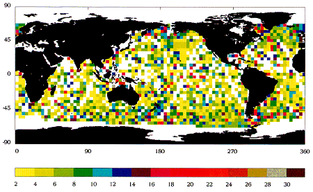
For more recent Doris orbits, the overall mean rms deviation is typically only 14 cm, without a posteriori correction of orbital error. This is roughly a third of the best results obtained in similar conditions by previous altimeter missions. The orbit and some of the geophysical corrections will also be further enhanced soon.
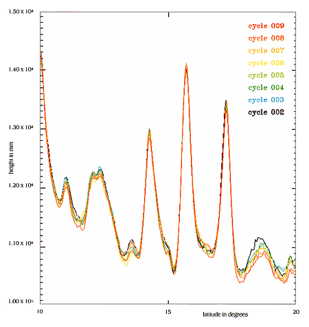
The along-track sea-surface heights over consecutive cycles are extremely consistent. The range is on the order of ±10 cm (see Figure 2), some of the temporal variations being of course related to real ocean changes (the main along-track variations are due to the geoid). Topex operated during cycles 2, 4, 5, 6, 7 and 9, and Poseidon in cycles 3 and 8. The agreement between the altimeters is outstanding.
Quick-look products
Topex/Poseidon measures three ocean parameters: significant wave height, absolute wind speed, and of course sea surface topography. These parameters and the geophysical corrections (ionospheric and tropospheric) were mapped throughout the nine processed cycles.
The cover of this Newsletter shows the mean surface topography for the nine cycles, in cm, relative to the OSU91A geoid model. The data is gathered into 4° latitude by 4° longitude boxes, then smoothed by a Gaussian procedure between adjacent boxes. This surface topography, generally known as dynamic topography, is directly related to the large-scale ocean currents. These currents follow the lines of constant dynamic topography. In the northern hemisphere they turn clockwise around the topographic highs and anti-clockwise around hollows. The general ocean circulation consists of large gyres with strong currents on their western boundaries.
The cover figure clearly shows well-known gyres and western boundary currents such as the Gulf Stream, the Kuroshio and the Brazil/Falklands confluence region. The Antarctic Circumpolar Current is also plain to see. Note the relative high dynamic topographies of the western equatorial Pacific "warm pool".
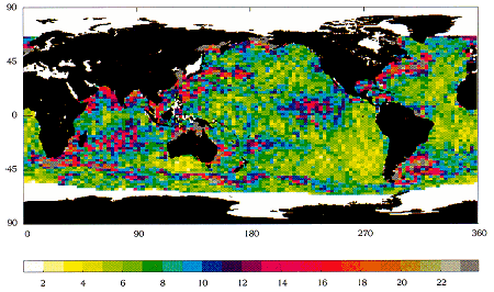
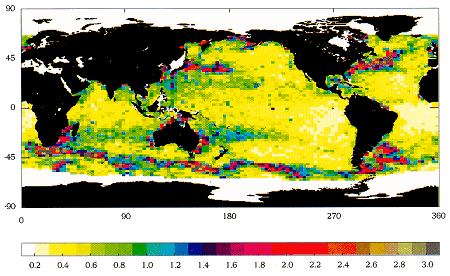
The temporal dynamic topography variations can be studied from the residuals file described above. Figure 3 represents the rms deviation of the sea level variability for the first nine cycles. The rms deviation of the sea surface slope (1 µrad at 45°N corresponds to a speed of 10 cm/s) is given in Figure 4. This figure shows the variations with the smallest spatial scales, i.e. the ocean mesoscale. The areas of strong ocean variability related to major ocean currents (Gulf Stream, Kuroshio, Brazil/Falklands confluence region, Antarctic Circumpolar Current) are prominent.
The maps agree well with the results of previous altimeter missions, given that in three months we have observed only about half of the ocean variability spectrum. Some areas such as the eastern equatorial Pacific show sea level variabilities that are slightly too high, probably due to ocean tide errors. These errors will be attenuated when more accurate tide models are used to produce the GDRs.
In areas with low ocean variability, the rms variability of the sea level is typically only 3-4 cm, the current upper limit. This is all the more encouraging in that, unlike previous altimeter missions, this result was achieved without removing long-wavelength signals. With this precision we will be able, for the first time, to study long-wavelength ocean variations.
Accurately determining the general circulation and its large-scale variability, such as that which gives rise to El Niño events, is the main objective of Topex/Poseidon. These first analyses from preliminary data show that our ambition is within reach. Longer time series will of course be needed to reveal all the variations.