


Topex/Poseidon: all systems running smoothly
Philippe Escudier (Cnes, France)
Topex/Poseidon is a satellite oceanography mission to determine the ocean circulation. It is designed and operated by the United States and France. All systems and subsystems are optimized to produce the most accurate measurements possible. Topex/Poseidon will be the reference mission for future series of altimeter satellites.
Features of the innovative choice of the Topex/Poseidon orbit include:
- 1300 km altitude to reduce drag,
- inclination of 66° so that the satellite covers most of the oceans and accurately measures tide effects at all local times.
To provide the greatest possible accuracy and validate technologies for the future, the measurement systems are redundant.
The trajectography calculations, so vital to an altimeter mission, use data from Doris (Cnes), laser (Nasa) and GPS (Nasa); the height measurements are done by Nasa's Topex dual-frequency altimeter and the Cnes experimental Poseidon altimeter, and also use the Nasa TMR radiometer.
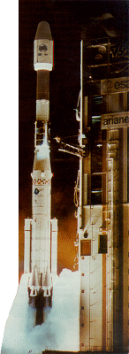
After the faultless Ariane flight 52 on August 10, 1992, the first month was devoted to switching on and testing the instruments. Over the next five months we checked the accuracy of the measurements and re-tuned the data processing algorithms.
This phase ended with the scientists joining for the JVT meeting on February 22-25 at the Jet Propulsion Laboratory (JPL) in Los Angeles.
The results were good enough to formally start the Observational phase for a period of three to five years.
The data will be made available to the whole scientific community from July 1993.
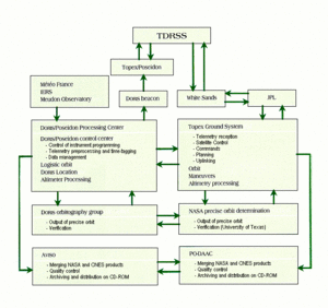
How the data is routed
All the instrument measurements are downlinked to JPL three times a day via the TDRSS satellite relay system and used to control the satellite. The measurements from the French instruments are extracted and sent daily to Cnes in Toulouse, France for instrument verification and data processing. The Geophysical Data Record (GDR) products are generated in parallel at JPL (Topex GDRs) and Cnes (Poseidon GDRs). The procedures for exchanging data between the centers insure that all information is distributed to all scientists.
There's a lot of processing to do on the data. It includes calculating the satellite trajectory to within a few centimeters using the orbitography measurements and theoretical models of the satellite motion in orbit.
The raw altimeter data is corrected for instrument errors, ionospheric and tropospheric effects, and reflections by surface waves. The software used to quality-control and process the data in Toulouse consists of around one million lines of code.
The commands for the French instruments are generated in Toulouse, then sent straight to Doris or through JPL and TDRSS.
This international cooperation is going well. A few hours have been enough for JPL to detect any urgent problems, then for Toulouse to analyze them and for the commands to be generated and uplinked.
The satellite
The 2500-kg satellite is fulfilling its mission perfectly.
Six maneuvers put the satellite onto its final orbit, achieved on September 21, 1992.
Since then, orbit correction maneuvers have been done regularly to keep the ground track within the grid.
We were slightly worried at lift-off when the batteries, similar to those used for previous missions, proved defective. The problem was overcome by reducing requirements: loads were controlled, and the charge current was reduced when the satellite exited eclipses. Battery status is now nominal.
The only real problem on the satellite bus concerned attitude control: the altimeter antenna pointing accuracy did not meet the specifications. This increased noise levels and induced errors which we could correct only partly. After we modified the onboard software, this was improved early in cycle 8 (December 1992) and fully overcome in January 1993.
Trajectography systems
Doris was switched on on August 16, 1992 and has been supplying some 6000 measurements a day ever since. Measurement accuracy, slightly better than Doris/Spot-2, is around 0.5 mm/s.
Intensive work has been done to track the satellite by laser measurements. Joint use of Doris and laser measurements has provided exceptionally accurate orbit calculations. The onboard GPS demonstration receiver has operated part of the time and confirmed its potential for use in precise trajectography calculations.
This accuracy has been one of the points that puts Topex/Poseidon in a different class from previous missions. It is vital to absolute, global measurements of sea level and its variations, a key mission objective. It has been achieved by using three high-quality independent systems. Precision on the orbit calculation is today better than 10 cm, as borne out by the difference between the results obtained by the various systems.
Radar altimeter systems
Performance of Topex, the main instrument, is up to all our hopes. The design derives from that used for the Seasat and Geosat missions. The main enhancement has been the addition of a 5.3-GHz measurement to the main 13.65-GHz measurement to correct for propagation through the ionosphere. The Cnes Poseidon altimeter is an experimental instrument to demonstrate the qualities of the new technologies used.
As the two altimeters use the same antenna they cannot operate simultaneously.
The French altimeter Poseidon had been on for 23 days by February 1. Data processing so far shows that it is operating perfectly. It is doing measurements of all the ocean areas it flies over and of some of the land masses such as ice sheets and deserts.
Precision of the ocean height measurements is 2 to 3 cm, according to wave height. Ionospheric effects are being satisfactorily corrected, thanks to Doris. The quadratic error between the dual-frequency correction by the Nasa altimeter and the Doris correction is under 2 cm.