


Validating merged Topex/Poseidon data
Jacques Stum (CLS, France)
The purpose of the Topex/Poseidon processing system set up by CLS under the Calval/Quick-look project is to:
- check the quality of all data and algorithms,
- output graphics products for demonstrations
The Aviso Interim Geophysical Data Record-Merged data (IGDR-Ms) is first analyzed and validated using simple devices such as histograms, scatter plots, and various types of maps. Poor-quality measurements-e.g. those on ice, or with corrections missing, spurious points and so on-are then rejected. This removes some 15-20% of the data. The result is files of validated points for each processed cycle. We then analyze the height differences at crossover points to assess the orbit quality and test all the corrections applied to the data. At this point the data is ready for oceanographers.
More detailed analyses of wet tropospheric and ionospheric corrections are also done. These are a means of characterizing the corrections-geographic variations, signal and error spectra-and thus make the data more useful. The analyses also help to choose the best corrections to apply to the range measurements. The wet tropospheric correction, i.e. correction for water vapor, is the most critical because it varies rapidly over time and space. The most efficient way of calculating the correction is to use the Topex Microwave Radiometer (TMR) on board the satellite. This dedicated instrument measures the natural radiation from the ocean and atmosphere at 18, 21 and 37 GHz. The radiation is mainly a function of water vapor and cloud cover.
Figure 1 shows the map of the wet tropospheric correction obtained from TMR measurements over ten days in January 1993. The color scale ranges from 30 mm (yellow) to 390 mm (brown). Note the high values in the intertropical convergence zone (very wet air) and the low values in the cold, dry air of the high latitudes. Numerical weather prediction models also provide the humidity.
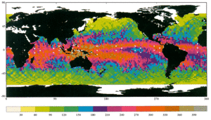
Figure 1: Wet tropospheric correction (in mm) from TMR for cycle 13 (IGDRMs).
Figure 2 compares the wet tropospheric correction obtained using the European Centre for Medium-range Weather Forecasting (ECMWF) model (x-axis) and using the TMR (y-axis) for the same period of time. TMR is always globally less humid than ECMWF. TMR in situ calibration experiments for the TMR-comparisons with ground-based radiometers and with radiosondes-have shown that TMR measurements are biased low, under-estimating the water vapor correction by about 10%. The instrument has therefore been recalibrated and the final data will have updated TMR corrections.
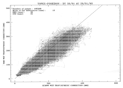
Figure 3 shows the ionospheric correction map using the Doris system on descending (daytime) passes during the same period. The color scale varies from 15 mm (violet) to 285 mm (red). This correction shows weaker spatial variations than for water vapor. The high values are in tropical regions, on either side of the magnetic equator. The correction is being validated, chiefly by comparing it with the ionospheric correction deduced from Topex dual-frequency measurements.
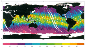
Figure 3: Ionospheric correction (in mm) from Doris system for descending tracks, cycle 13 (IGDRMs).