


Calibration campaign contribution
The experience of calibration/validation operations (Cal/Val) during the T/P mission has demonstrated the need to develop sites and ground experiments to control the instrumental drifts, which can occur on space altimeter equipment as well as on in-situ instruments.
We have a threefold experience in this field.
- First of all, precise orbit validations, with the development and the systematic use of a short arc orbit determination method based on laser telemetry data from a regional network [Bonnefond & al., 1995].
- Then, a calibration and collocation campaign in a new site in Corsica using the ultra-mobile laser station (FTLRS) operationally for the first time in 1996/97, then during 2002, 2005 and 2008 campaigns. The station was also used in an international collaboration frame with a campaign in Creta in 2004, in support to Gavdos calibration site, and another in Tasmania in 2007-2008, in support to Burnie calibration site. The last FTLRS campaign was made in Corsica in 2008 for cross comparisons between Jason-1 and Jason-2.
- Finally, the laser instrumental biases estimations over time, and their stability, which is a more and more important component for orbit determination and precise location in space geodesy [Bonnefond & al., 1999].
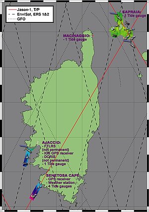
In the framework of the Jason program, we have proposed to Cnes and Nasa, a general error balance study of the orbit (tracking measurements, corrections, reference frame), and a double calibration campaign in Corsica (figure 1) and in Grasse with the ultra-mobile laser station and the fixed one of the Calern Plateau.
Corsica calibration sites
In Macinaggio, site located in the northern part of Corsica (figure 1):
- One tide gauge submerged in the harbor, installed by OCA, LEGOS and IGN, in 2003 mainly devoted to study of ocean dynamics in the Corsica-Capraia strait but also for calibration/validation
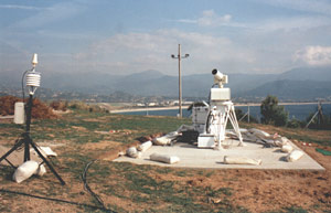
In Aspretto, geodetic site located 2 km from Ajaccio and dedicated for Envisat calibration (also SARAL/AltiKa in a near future):
- a GPS permanent site, installed by Cerga & IGN in 1999,
- a tide gauge permanent site (continuous ultra-sonic measurement), installed by Cerga & Epshom in 1999,
- a Doris station, installed by Cnes-Jason project beginning 2002,
- <link internal-link>laser campaigns - FTLRS, with firings on Jason-1, T/P, and for positioning purpose on Lageos, (figure 2)
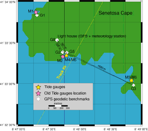
In Senetosa, main calibration site for T/P and Jason missions located at 40 km from Ajaccio (figure 3)
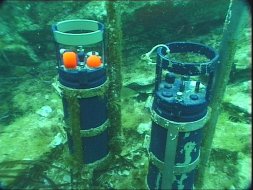
- Four tide gauges submerged on both sides of the Jason-1 - Topex n° 85 ascending track, installed by Cnes-Jason project, IGN, and Cerga and again ten years after in 2009 where only millimeter differences has been found (figure 4),
- A fundamental GPS reference point near the Senetosa's lighthouse, with GPS survey ties and classical leveling for tide gauges: performed in 1998 by Cerga, Cnes and IGN and again ten years after in 2009 where only millimeter difference has been found,
- sea level measurements performed with GPS-buoys in the Senetosa bay including survey ties of sea level with tide gauges performed by Cerga, Cnes and a JPL team, in 1998 and 1999, and continuously since 2010 (at every overflight when sea conditions are not too harsh).
The Macinaggio and Senetosa tide gauges time series are now freely available to users.
Click to download the data |
Besides the sites described above, several experiences realized these last years (2004 for Capraia and 2005 for Ajaccio) enable to do in Corsica a multi-satellite calibration (Topex/Poseidon, Jason-1 & 2, ERS-2, Envisat and GFO) over different dedicated sites (figure 1).
All the campaigns realized since Jason-1 launch thus enable to extend Corsica site calibration capabilities. In parallel, software and standards (based on IERS 2003 conventions) were updated in order to respond to the Topex/Poseidon, Jason-1 and Jason-2 missions datasets.