


Altimetry Sea Ice products from CTOH
Types of dataset: Gridded Altimetry Sea Ice product for Envisat and Cryosat-2.
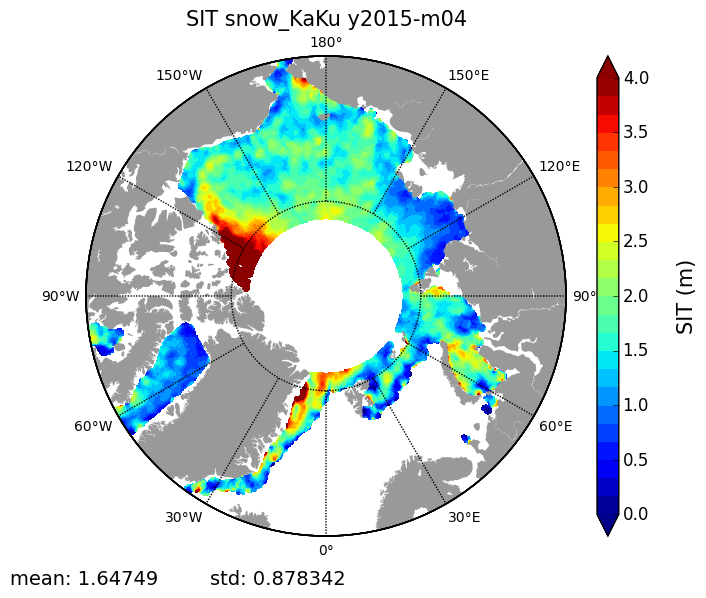
Contents: Gridded Altimetric Sea Ice Thickness, Sea Ice Freeboard, Snow Depth, Snow Density, Sea Ice density, Sea Ice thickness uncertainty, multi year ice fraction for Envisat and Cryosat-2.
Use: Climate, ocean/atmosphere studies, primary production,...
Condition of access: products delivered for any purposes as stated in the licence agreement.
Data access service: FTP, TDS
Description: The Altimetry Sea Ice product is computed by CTOH and is estimated from the Envisat (2002-2012) and CryoSat-2 (2010-present) ESA satellite missions.
Geographic coverage:
Arctic:
65°N < latitude < 88°N for Cryosat-2 and 81.5°N for the other datasets.
Antarctic (soon available):
88°S for Cryosat-2 and 81.5°S for the other datasets < latitude < 55°S
Format: NetCDF-4 Classic.
Tools:
- CTOH Altimetry Sea Ice product User Handbook
- Article in the Newsletter 16
References:
- For Envisat and CryoSat-2 FB and SIT :
- Guerreiro, K., Fleury, S., Zakharova, E., Kouraev, A., Rémy, F., Maisongrande, P., 2017. Comparison of CryoSat-2 and ENVISAT radar freeboard over Arctic sea ice: toward an improved Envisat freeboard retrieval. The Cryosphere 11, 2059–2073. https://doi.org/10.5194/tc-11-2059-2017
- For the Snow Depth :
- Garnier, F., Fleury, S., Garric, G., Bouffard, J., Tsamados, M., Laforge, A., Bocquet, M., Fredensborg Hansen, R. M., and Rémy, F.: Advances in altimetric snow depth estimates using bi-frequency SARAL/CryoSat-2 Ka/Ku measurements, The Cryosphere Discuss. [preprint], https://doi.org/10.5194/tc-2021-79 , in review, 2021.
- Guerreiro, K., Fleury, S., Zakharova, E., Rémy, F., Kouraev, A., 2016. Potential for estimation of snow depth on Arctic sea ice from CryoSat-2 and SARAL/AltiKa missions. Remote Sensing of Environment 186, 339–349. https://doi.org/10.1016/j.rse.2016.07.013
Citation: Publications should include the following statement in the Acknowledgments:
“The data used in this study (doi 10.6096/CTOH_SEAICE_2019_12) were developed, validated by the CTOH/LEGOS, France and distributed by Aviso+”.
Copyright : 2002 - 2019 These products were developed and validated by the CTOH/LEGOS.
Altimetry Sea Ice product
Satellite | Authenticated access service | Content | Area | Type | Data period | Main variables |
|---|---|---|---|---|---|---|
| Cryosat-2/Saral | Available via your personal space: MY AVISO+ | one file containing monthly means for each 25km and 50km filtering radius | -Arctic | L4 gridded | 2013-2019 | -Sea ice Freeboard -Alti Snow Depth -Sea Ice Thickness |
| Cryosat-2 | 2010-2019 | -Sea ice Freeboard -Modified Warren Snow Depth -Sea Ice Thickness -Sea Level Anomalies | ||||
| Envisat | 2002-2012 | -Sea ice Freeboard -Snow Depth: Modified Warren (Arctic) AMSR (Antarctic) -Sea Ice Thickness |
Data
- Products guide.
 Products .
- Sea surface height products .
- Value-added products .
- Wind/wave products .
- Auxiliary products .
- Ice products .
- CFOSAT SWIM Ice products.
- Altimetry Sea Ice products from CTOH.
- SGDR+ Ice Sheet products.
- Ocean indicators products .
- Ocean data challenges .
- In-situ products .
- Data access .
- Tools .
- Product information .
- CALVAL .
- Operational information .