Mobile version

News

10.08.2012 07:41 Age: 12 yrs

Twenty years ago ... Topex/Poseidon was launched

Category: News of the other missions

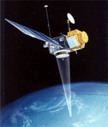
When Topex/Poseidon was launched from Kourou on 10 August 1992, it was already a successful outcome for all the work involved in the frame of a cooperation between Nasa and Cnes, both on the human and the technical planes.

The 13-year mission that followed (until 2005) marked the beginning of a new era in altimetry including a blooming applications and a growing community (see Image of the month, <link internal-link>August 2012).

The mission's success is also lies in the fact that during this life, Topex/Poseidon was not alone and the history still continues with the current missions.

Indeed, merging satellites in flight simultaneously on different orbits, such the association between Topex/Poseidon and ERS was a fine example how altimetry satellites can operate together to track with a high spatial resolution the ocean variations.

Topex/Poseidon is also the first satellite to describe a reference orbit, exactly follows by Jason-1 (from 2001), by Jason-2 (from 2008) and soon by Jason-3 (2014) and Jason-CS (2017). The cumulative duration of all of these missions is also the key of success  to build a time series long enough to better understanding the interannual variations and the climate change.

The story continues...

<link fileadmin images altimetry tp_1st_cycle_vs_100years.png download>
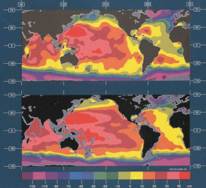
<link fileadmin images news mod_actus download>

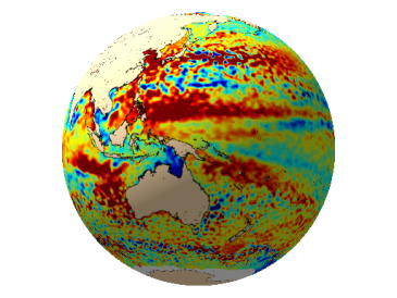
Ten days of Topex/Poseidon satellite measurements (top) provide more details than in situ observations over the last hundred years (bottom).

Map of the day (2012/08/10), twenty years after the launch of T/P, Ssalto/Duacs Near-Real Time merged map of Sea Level Anomalies around the globe (click to animate).

Further information:

  • Missions:
    • <link internal-link>Topex/Poseidon
    • <link internal-link>Thirteen eventful years
  • Image of the month, August 2012: <link internal-link>Altimetry, 20 years and still growing
  • Altimetry: <link internal-link>Altimetry history


EnglishFrançais
Rss feedsContactPartnersFAQLexiconLegal noticePersonal Data Protection PolicyMobile
You must enable cookies in your browser preferences to save the modifications
You are using an older version of Internet Explorer, please update to take full advantage of Aviso+ features

Customize the home page

View all widgets
Reduce display
Public profile
User profile

Select/Deselect widgets

Discover AVISO+

Customizable home, reading tools, products search guide, etc.. Discover step by step the features of the new site AVISO+.

Customizable homepage

This home page is composed of blocks called "widgets".

Rearrange the blocks with a "Click & Drop".

Hide a widget with the cross at the top right. Reset or add a widget with the "wrench" icon. The "User" and "Public" profiles offer a predefined organization.

All the modifications are automatically saved as cookies on your machine so as to enable you to have your own specific AVISO+.

Reading tools

Ease your reading by choosing the page background colour (black/white) and/or by modifying the font size.

Browsing menu and breadcrum trail

To ease your browsing through AVISO+, you can use at any time the main banner items with the interactive submenus or use the browsing menu on the left side of the screen (it is open by default). For more readiness of the page contents, you can fold and unfold the browsing menu by clicking on the tab. At any time you can know where you are thanks to the browsing menu or the breadcrum at the top of the page.

Products search guide

The first submenu of the "Data" banner item leads you to a new search form enabling you to find quickier the product that suits your needs. The list of results is updated according to your selection criteria.

AVISO+ Multimedia

The first submenu of the "Multimedia" banner item leads you to AVISO+ collections of images and videos linked to altimetry and its applications. Have a nice visit!