


News
Flooding in Nigeria
The 2012 annual rainfall season and releases of water from reservoirs causes flash and massive floods in Nigeria. Satellite altimetry enables to monitor the water level using specific processing in a dedicated-hydrology products on lakes, rivers or wetlands.
The 2012 annual rainfall season causes flash and massive floods in Nigeria. Releases of water from the Kiri Dam in Adamawa State and from Lagdo Dam in the Republic of Cameroun have contributed to further swell the Benue River.
Satellite altimetry enables to monitor the water level using specific processing in a dedicated-hydrology products on lakes, rivers or wetlands. Examples are given on two areas along the Benue river on Jason-2 pass #096 (left) and pass #172 (right).
Both time series show similar variations and high water levels since August. The latest point of each time serie ( Jason-2 cycle 154, which corresponds to 2012/09/09 for pass #096 and 2012/09/12 for pass #172) shows that the flood peak is not yet reached.
<link fileadmin images news mod_actus download map nigeria>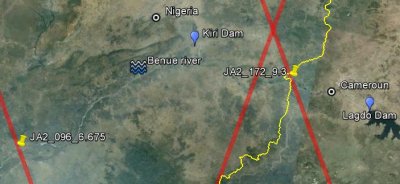 |
Localisation map of the two areas where the time series below are plotted: "JA2_096_6.675" corresponds to the time series over the pass#096 whereas the "JA2_172_9.3" corresponds to the pass #172. The dams are also localised. |
<link fileadmin images news mod_actus download>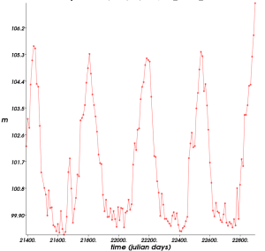 | <link fileadmin images news mod_actus download>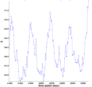 |
Time series (in julian days) of altimetry-derived heights (in meters) over the Benue river, Nigeria.These measurements were done with the Jason-2 data under pass 096 (left) between 2008/07/15 (cycle 001) and 2012/09/09 (cycle 154), and pass #172, between 2008/07/18 (cycle 001) to 2012/09/12 (cycle 154). The data are provided by Pistach project (IGDR products with a specific treatment adapted to continental waters). The exact latitudes coordinates for a given ground track are shown when clicking on each image. Use the <link internal-link>pass locator to locate the ground track with Google Earth. Use the <link internal-link>calendar tool to convert julian days to calendar days. The curves are drawn with the <link http: www.altimetry.info _blank external-link-new-window>Basic Radar Altimetry Toolbox. Credits CLS/Cnes. | |
Further information:
- Data: <link internal-link>Coastal and hydrological products.
- Applications: <link internal-link>Hydrology
- Earth Observatory website:
- September 2012: <link http: earthobservatory.nasa.gov iotd _blank external-link-new-window>Flooding in Nigeria
- October 2012: <link http: earthobservatory.nasa.gov naturalhazards _blank external-link-new-window>Flooding in Southern Nigeria


