


News
Altimetry applications in videos : Venice
The city of Venice has suffered assaults from the sea for many years. By improving the quality and quantity of altimetry measurements, the Jason-2 satellite will contribute to its protection.
 See the Venice video: flash (9 Mo) or mpeg (32 Mo)
The former republic of Venice, which stretched from the Dalmatian coasts to Cyprus along strategic sea routes, has today become a city of about 300,000 people, incorporated into Italy, and still with an eye on the sea in terms of its commercial interests. Venice, the City of the Doges, has suffered assaults from the sea for many years. To avoid silting, the Po and its tributaries have been diverted since the seventeenth century. However, floods have increased in the twentieth century and the Venetians still remember the terrible acqua alta in 1966 when the rising waters reached a record height of 1.94 m.
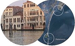
Venice is at the heart of a lagoon, at the centre of a naturally changing and fragile area stretching along 50 km, including 118 islands, and connected by 160 km of natural or artificial channels. It is separated from the Adriatic Sea by a narrow sandy bank (lido), itself open to the sea in three places: the Lido, Malamocco and Chioggia inlets. These entrances ensure renewal of the water but also expose the lagoon to the threat of the rising sea level, high tides and waves induced by the wind that come from the open sea (the Sirocco) or the land (the Bora). Other factors can amplify this high water phenomenon. The soil, composed mainly of clay and silt, is unstable. The wooden pillars, making up the foundations of the wonderful palaces, are fragile. To make matters worse, Venice is also sinking due to the indiscriminate pumping of freshwater from a deep aquifer beneath the city. Urbanization and harbour activities have also changed the hydraulic flow in the lagoon: the sea rushes in more easily and powerfully via the deep, smooth artificial channels.
To protect Venice and its lagoon from the rising waters, a titanic (and controversial) project is underway, which should be completed in 2012: the Moses Project. This consists in building a series of 79 hollow, mobile gates at the bottom of the Venetian lagoon's three entrances. During normal conditions, the gates will be folded back over the bottom. They are then raised to hold back the sea in times of acqua alta, when the sea level reaches 110 cm.
The long and narrow configuration of the Adriatic Sea makes it difficult to observe with altimetry:
- The direction of the satellite ground tracks limits the section of the sea overflown (only one Jason-1 track - no 237 - presents a maximal section of 460 km),
- A combination of water and land areas prevents the radar from locking on any of these surfaces for long enough.
The launch of Jason-2, in June 2008, and the planned shifting of Jason-1 to a new midway orbit, will improve the spatial resolution. With merged data, mesoscale phenomena can be better described and tide models will be greatly enhanced. With a new measurement processing algorithm onboard, it will be more proficient at defining land/water transitions and thus achieve greater accuracy.
Further information:
- Missions: <link internal-link>Jason-2
- Ocean indicators: <link internal-link>Mean sea level maps and curves on a global scale or in Mediterranean Sea
- Applications: <link internal-link>Oceanic tides.
- Altimetry: <link internal-link>High-precision altimetry with satellites working together


