


News
Saral: first maps of Sea Level Anomalies
In orbit since a few months, Saral show very good results; a good news to integrate Saral mission into the Duacs multi-mission in the coming weeks.
In orbit since a few months, Saral has just begun to collect data on its cycle 3 (2013/05/23). So far all results are very good and the Ka band altimeter, the radiometer, and the Precise Oorbit Determination payload (Doris and laser) provide very good results.
The analysis of the level-2 data (O/IGDRs) quality is going smoothly over all surfaces, including land ice, inland water and obviously ocean.
The map below (left) displays the sea level anomalies measured by all Saral ground tracks (separated of 75 km at the Equator) over the last 35 days (duration of the Saral repetitive cycle).
A same map is displayed for the Jason-2 mission which the ground track separation at the Equator is larger (315 km) during the same period (35 days for Jason-2 represent about 3.5 cycles).
Both are very close, the integration of Saral mission into the SALP/Duacs multi-mission system will so be prepared in the coming weeks.
<link http: www.aviso.oceanobs.com fileadmin images news saral>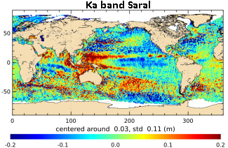 | <link http: www.aviso.oceanobs.com fileadmin images news saral>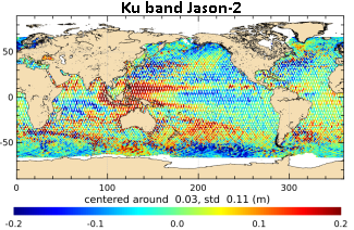 |
Maps of Sea Level Anomalies computed from IGDR (orbit MOE) for Saral in Ka-band (left) and for Jason-2 in Ku-band (right) between 2013/04/15 and 2013/05/20. This 35-days period represents one cycle for Saral and about 3.5 cycles for Jason-2. The anomalies are centered around 0.03m. Credits CLS/Cnes. | |


