


News
Saral also provides promising results over the Amazon river
The analysis of the Saral products over inland water is ongoing and already shows very good agreement when compared with in situ water level records. Here, an example over the Amazon river.
The analysis of the Saral products over inland water is ongoing. Saral provides a new opportunity to monitor remotely the level of the major rivers, and comes at a perfect time to allow a continuous monitoring of rivers by carrying on the time series of data for inland waters initiated with ERS-2 in 1995, then continued with Envisat in 2002.
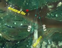
These plots present the river level measured over an intersection of Saral ground tracks (pass number 063 and 478) with the Amazon (near the Amazon and Madeira confluence). The water levels are compared with the in situ measurement at Iracèma, available just 3 km upstream.
<link http: www.aviso.oceanobs.com fileadmin images news saral>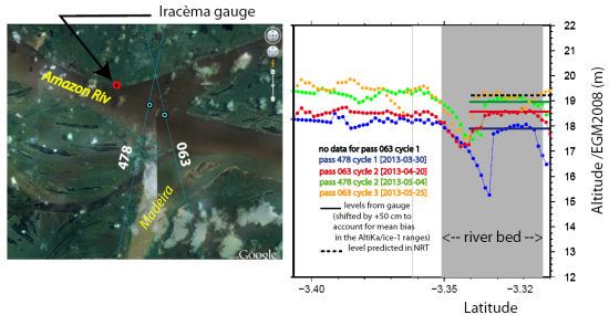 | i2 |
Water surface altitude (in meters) over the Amazon river (near the confluence of Amazon and Madeira rivers) along the Saral #063 and #478 ground tracks, between cycle 1 and cycle 3 (no data from pass #063 on cycle 1). Each curve represents the altitude in meters (Y-axis) along the ground track (X-axis represents the latitude) at a given cycle so each curve for a given pass is spacen from 35 days. Use the <link internal-link>pass locator to visualize the ground tracks with Google Earth. CréditsCnes/Legos/IRD, S.Calmant.
| |
<link http: www.aviso.oceanobs.com fileadmin images news saral>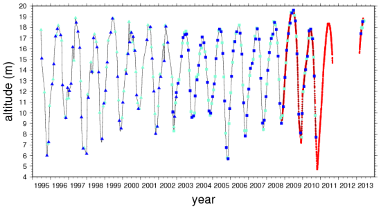 |
Water levels time series derived from ERS-2 (triangles) between 1995-2002, Envisat (squares) between 2002-2010 and Saral (circles) from 2013. The blue and cyan colors used for the water level derived from altimetry correspond to passes #063 and #478. Both tracks are separated of 14 days for a given cycle. The red line superimposed are derived from in situ measurements at the Iracèma gauge, located 3 km upstream. Missing blue squares between 2010 and 2012 correspond to an orbit change for Envisat beyond November 2010. The missing red line between 2011 and 2013 correspondonds to a lack of in situ measurements. Credits Cnes/Legos/IRD, S.Calmant. |
The agreement between in situ water level records and Saral data is already very good. In the coming months, we will further increase the Saral data quality over inland water by using dedicated processing methods
Further information:
- Applications: <link internal-link>Hydrology, <link internal-link>Rivers
- News, 2012-06-05: <link http: www.aviso.oceanobs.com en news-storage _top external-link-new-window>Record flood in the Amazon basin
- News, 2009-05-14 <link http: www.aviso.oceanobs.com en news-storage news-detail _blank flood on the amazon>Exceptional flood on the Amazon river
- Image of the month:
- April 2010: <link internal-link>Drought and floods in the Amazon basin
- Mar. 2007: <link internal-link>Malaria and altimetry in the Amazon
- Oct. 2001: <link internal-link>The Amazon under close surveillance
- Altimetry applications in videaos: <link internal-link>Hydrology
- Data use case in Radar Altimetry Tutorial : <link http: www.altimetry.info html use_cases data_use_case_amazon1_en.html _blank external-link-new-window>Temporal water surface height variations in enclosed areas: the Amazon Basin


