


News
Altimetry applications in videos : Fishing management
Sustainable management of marine resources is important given the enormous stakes involved. The launch of the Jason-2 in June 2008 will contribute to this effort by providing a physical description of the oceans.
 See the video Fishing management: flash (9 Mo) or mpeg (33 Mo)
Fishing, an occupation which is physically trying and financially difficult, depends on a resource which is fragile and subject to pollution and global warming - in a market that is global and speculative all of which leads to alarming ecological and economic results . Seventy-five percent of known species are fully exploited or overexploited (FAO, 2005). It is difficult to rewrite this equation in such a way that the solution tends towards a balance between the conservation of fish stocks and the long-term survival of commercial fishing, which means that each variable in the fishery industry must be carefully examined.
Illegal fishing still accounts for a too-large proportion of the catch, which weakens the equilibrium of stocks and ecosystems, skews the market, and thus harms legal and sustainable fishing activity.
Satellites can be used to fight illegal fishing. The exclusive economic zone around Kerguelen (a French island in the southern Indian Ocean, which is difficult to reach and far from standard maritime routes) has a highly valued market resource - the toothfish. This zone is monitored in real time by combining satellite radar images (Radarsat-1 and Radarsat-2, Envisat) and Vessel Monitoring Systems onboard ships. An illegal ship (Apache) was stopped and examined, then confiscated in 2004 using these means. Since then, they have effectively eliminated 95% of illegal fishing in this zone.
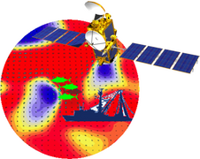
Altimetry, by measuring sea surface height, identifies the troughs and ridges around which the currents rotate. In this way, the radar technique clearly reveals fronts and eddies. The joint use of altimetry and other satellite sensors, capable of measuring the surface temperature and the chlorophyll content, can identify zones with intense biological activity, where phytoplankton and fish proliferate. These satellite data are used to model the distributions of fish populations, optimise fishing effort, and identify vulnerable zones and ships in illegal situations. Sustainable management of marine resources, protection of threatened species and understanding the impact of climate change on marine life are important given the enormous stakes involved. The launch of the Jason-2 altimetry satellite in June 2008 will contribute to this effort by providing a physical description of the oceans.
Further information :
- FAO, <link http: www.fao.org fishery topic external-link-new-window>Management and conservation of aquatic resources
- <link http: www.cls.fr html solutions peche welcome_en.html external-link-new-window>CLS, Fisheries management with a satellite-based Vessel Monitoring System (VMS).


