


News
Jason-3 mission returns first data
Jason-3 was successfully launched Sunday 17 January. All the instruments were rapidly switched on. The first real-time Jason-3 data product was generated and compared with Jason-2, less than three days after launch.
The Jason-3 oceanography satellite, developed by CNES working with international partners and successfully launched Sunday 17 January from Vandenberg Air Force Base (VAFB), California, by a Falcon 9 launcher, has reached its operational orbit. Immediately after being injected into orbit by the launcher, the satellite came under control of teams at the Toulouse Space Centre and all systems on the Proteus bus and all the instruments were successfully switched on. The teams were then able to generate the first real-time Jason-3 data product, less than three days after launch. Over the course of the next few days, Jason-3 will be joining its predecessor Jason-2, trailing one to three minutes behind in the same orbit to allow cross-comparison of data for the next six months. It will then take its place in CNESâs historic series of altimetry satellites and begin its mission to extend the record of sea-surface height data in support of climate change monitoring efforts engaged at the COP21 climate conference.
A collaboration of CNES, NASA, NOAA and Eumetsat, Jason-3 will continue the reference altimetry mission for the Copernicus-MyOcean service, supporting the study of sea level variations, surface wave height and wind speed for meteorology and navigation, and continental altimetry vital for continental hydrology and operational oceanography. Jason-3 is the latest in the series of satellites that draw their heritage from the pioneering TOPEX/Poseidon altimetry satellite, launched by CNES in 1992, which marked a watershed in the study of ocean movements before bowing out in 2006, having exceeded its design life by more than eight years. In 1997-1998, TOPEX/Poseidon was the first to closely track an El Niño/La Niña episode from space, revealing all the early telltale signs of the bulge of warm water propagating across the ocean 20 to 30 centimetres above the average sea-surface height, thus providing proof of the oceanâs role in Earthâs climate system.
From its highly inclined 1,336-kilometre orbit, Jason-3 covers 95% of the globeâs ice-free oceans every ten days. Planned to operate for three years with a possible extension to five years, it will assure the data continuity so vital to effective monitoring of global warming through to at least 2021, before being joined by two other satellites, Jason-CSA/Sentinel-6A and Jason-CSB/Sentinel-6B. Developed by CNES and Thales Alenia Space, Jason-3 is built around a Proteus spacecraft bus. It is carrying a Poseidon-3B altimeter, the main mission instrument that measures the range from the satellite to the ocean surface, an advanced microwave radiometer (AMR) to measure emitted radiation, a CNESdesigned DORIS orbit determination system, a GPS payload (GPSP) and a laser retroreflector array (LRA) developed by NASA/JPL. It is also carrying the CARMEN 3/AMBRE instrument supplied by CNES and the Light Particle Experiment supplied by the Japan Aerospace Exploration Agency (JAXA), which will be tasked with characterizing the satelliteâs radiation environment. | <media 15750 1000x600 - "IMAGE, 201601 J2J3 SWH OGDR, 201601_J2J3_SWH_OGDR.png, 133 KB">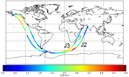 </media> </media> |
Map comparing significant wave heights measured by Jason-2 and Jason-3 measured on 2016/01/19, few hours after the altimeter was switched on. Credits CNES. |
Further information:
- Missions: <link internal-link>Jason-3


