


News
Campaign in the Lower Seine valley with GPS carpet/ Drone / Lidar
A campaign is taking place in the lower Seine valley with different sensors using several techniques to prepare Swot data validation in the future
The SWOT (Surface Water and Ocean Topography) mission, result of a Franco-American cooperation (CNES / NASA, with the participation of CSA and UKSA), will measure rivers, lakes and coastal and estuarine area water heights (and their spatial and temporal variations), using a new technical concept: interferometric altimetry. In 2021, after the launch, the performance of SWOT will have to be calibrated and validated thanks to the contribution of other space missions, to available in-situ data, but also by dedicated means deployed on site during the overflight of the satellite in order to have co-temporal measurements. These means must be able to be deployed in remote sites in order to have ground truths on non-instrumented sites, so they must be light.
 |  |
|---|---|
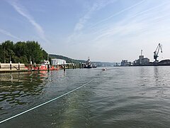
The GPS carpet in tow of the boat, and the Lidar | |
Among the various means envisaged to validate the SWOT measurements, the water height information derived from the GPS measurements on a specific buoy and / or the airborne Lidar and / or drone data are the most promising. In this context, CNES has asked its partners (IRD, INSU, CNRS, CLS, etc.) to develop resources that would be implemented during the Cal / Val phase in orbit in 2021. These resources have been developed and a test on the Seine estuary will take place on 22 and 23 June 2017 in order to validate the behavior of the different vectors.
The estuary of the Seine has been retained as a test zone because of the knowledge of this area and the availability of technical means by the âContinental and Coastal Morphodynamicsâ UMR CNRS 6143 team (M2C). Moreover, the monitoring of the water levels along the estuary by the tide gauges of the Grand Maritime Port of Rouen will provide an independent ground truth.
The CalNaGeo GPS data carpet produced by the Technical Division of the National Institute for the Sciences of the Universe (DT-INSU) in 2016 follows similar developments in the past for the validation of oceanographic measurements for the Jason-2 and 3 missions. The new design of the GPS carpet has been adapted to the problems of continental hydrology. It will be towed by a boat, the "MONOD-ROUEN" of the M2C laboratory.
A light weight altimeter was developed by engineers of the Collecte Localisation Satellites (CLS) company early 2017 to be embarked on a drone. It uses a lidar technology. The drone should follow the boat in order to compare the altimeter performance with those of the GPS carpet. It should fly in the wake of the boat, just in front of the GPS (about 30 m behind the boat, depending on the wake). The drone flies at 30 m altitude and two people (a telepilot and an operator) are planned on the boat to ensure its control. The drone has an automatic pilot with detection and avoidance of possible obstacles (bridges, electrical wires), the pilot being present on boat to take control in case of an incident.
At the same time lidar surveys will be carried out. The LIDAR instrument of the M2C laboratory will be onboard an aircraft that will fly over the lower Seine valley during the two-day campaign. These surveys will be carried out within the framework of the COTEST project coordinated by the M2C laboratory and supported by the CNES TOSCA program.


