


News
Typhoon Bolaven seen by Jason-2
Typhoon Bolaven hit the Japan and Korean coasts making a lot of damages. Jason-2 satellite has flown over the typhoon path and has observed it.
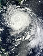
On August 26, 2012, Typhoon Bolaven passed over Japan’s Ryukyu Islands, the eye of the storm making landfall on Okinawa. The Moderate Resolution Imaging Spectroradiometer (MODIS) on NASA’s Terra satellite captured this natural-color image when Bolaven’s eye was situated southeast of the island (source <link http: earthobservatory.nasa.gov naturalhazards _blank external-link-new-window>earthobservatory.nasa.gov/NaturalHazards)
Altimeters have been designed to observe the sea level variability. Although the probability to fly over such a phenomenon is low, sometimes the satellite happens to observe ocean variability in the case of strong cyclones. In the case of Bolaven, Jason-2 overflew remarkably the Typhoon twice: on 21st and 24th August.
<link fileadmin images news mod_actus download> | Path of Typhoon Bolaven with its intensity overlaid on the two passes of Jason-2: pass 112 which overflew the typhoon on 21st at 15:48 and pass 177 on 24th at 05:03. |
|---|
The nominal measurements of the altimetry Sea Surface Height in case of extreme low pressure events are impacted by heavy rain and strong wind speed. <link http: www.mdpi.com _blank external-link-new-window>Carrère et al., 2009: "Observing and Studying Etreme Low Pressure Events with Altimetry", have developed specific altimeter and radiometer treatments taking advantage of the dual-frequency capabilities of altimeters in order to calculate Sea Level Anomaly (SLA) during those particular conditions. The methodology is applied here to observe the Typhoon Bolaven: when Bolaven was classified as TYPHOON-1 on 21st, the satellite observed a sea level elevation of about 20 cm along the track, compared to the normal oceanic variability (see figure on the left). In the case of the second observation on 24th (TYPHOON-4) a stronger sea level elevation (more than 60 cm) was observed. Note that the direct observation of very low pressure systems by radar altimeters begins to be investigated. Some work has been performed and the results provided here are a first estimation of what can be done. Indeed, they are still affected by errors because we are close to the limit of instruments and models capabilities.
<link fileadmin images news mod_actus download> | <link fileadmin images news mod_actus download> |
|---|
Recomputed Sea Level Anomaly (SLA) in meters as described in Carrère et al., 2009 for two passes of Jason-2: pass 112 on 21st at 15:48 (left) and pass 177 on 24th at 05:03 (right).
Further information:
- Applications: <link http: www.aviso.oceanobs.com en applications atmosphere-wind-and-waves hurricanes.html _blank external-link-new-window>Hurricanes
- Unisys weather Service: <link http: weather.unisys.com hurricane _blank external-link-new-window>weather.unisys.com/hurricane
- Nasa earth observatory: <link http: earthobservatory.nasa.gov naturalhazards _blank external-link-new-window>earthobservatory.nasa.gov/NaturalHazards
- <link http: www.mdpi.com _blank external-link-new-window>Carrère et al., 2009: "Observing and Studying Etreme Low Pressure Events with Altimetry"


