


News
Cryosat-2 data available on Duacs
Duacs data derived from the Esa mission Cryosat-2 will be delivered by Cnes on February 06th. All near-real time products from Duacs will be exploiting 4 altimeters (Jason-2, Jason-1, Envisat and Cryosat-2).
Duacs data derived from the Esa mission Cryosat-2 will be delivered by Cnes on February 06th . All near-real time multi-mission products from Duacs [1] will be exploiting 4 altimeters (Jason-2, Jason-1, Envisat and Cryosat-2).
This major change is the result of the long-standing and fruitful partnership between Esa and Cnes and a response to the request from scientific and operational oceanography users [2].
The Duacs multi-mission system will be ingesting data flows generated by Cnes' Cryosat Processing Prototype (CPP) which are derived [3] [4] from Level 0 data flows from Esa. The CPP processor includes a pseudo-LRM handling of Cryosat's innovative SAR mode [5]. Duacs will therefore benefit from a full global coverage of the Cryosat-2 altimeter. This coverage notably includes European Seas, the Agulhas area, and high latitudes latitudes (up to 89° for the first time ever).
<link fileadmin images news mod_actus download>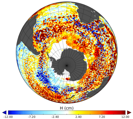 |
|---|
Multi-mission map of Sea Level Anomalies on 2012/01/01 exploiting 4 altimeters: Jason-2, Jason-1, Envisat and Cryosat-2. Credits Cnes-Ssalto/Duacs-Esa. |
There are three benefits for Duacs users :
- more along-track SLA data for model assimilation,
- higher resolution of multi-mission mesoscale maps,
- better resilience of the multi-mission observation system if an old altimeter becomes unavailable in 2012 [6].
Adding Esa's L1B and L2 products [7] and Noaa's recent Cryosat announcement [8], a wide range of Cryosat data should be available to the oceanography, geodesy, and weather forecast communities. Esa has also announced an improved ocean L2 product (IOP) in Spring 2012 [9].
However please note that all Cryosat products from Cnes are generated within 24 to 48 hours on a best effort basis, and that Cryosat has a higher error budget than other altimeters because of its cryosphere-oriented design (no radiometer, no dual frequency ionosphere, drifting orbit) [6]. Yet no major anomaly nor delay has been identified on the Duacs test system since November 2011.
Further information:
- [1] <link internal-link>Duacs data: <link internal-link>Level 3 along-track SLA, and <link internal-link>Level 4 multi-mission mesoscale maps, both global and regional.
- [2] Following the scientific recommendations from the OSTST meeting (San Diego, October 2011), the ESA Cryosat Project and the CNES SALP Project have been collaborating to generate these Cryosat-derived L3 and L4 products. Level 1B and Level 2 products derived from CNES processors are not distributed by AVISO as per the CNES / ESA agreement.
- [3] Picot.N., F.Boy (2011): CryoSat Processing Prototype, LRM Processing on CNES Side and a Comparison to DUACS SLA. Proceedings of the <link http: www.cryosat2011.org _blank external-link-new-window>2d Cryosat Validation Workshop (Frascati, 2011
- [4] Labroue.S et al (2011): First Quality Assessment of the CryoSat-2 Altimetric System over Ocean. Advance in Space Research (In Press). <link http: dx.doi.org j.asr.2011.11.018>dx.doi.org/10.1016/j.asr.2011.11.018
- [5] Boy.F et al (2011): Cryosat LRM, TRK and SAR processing. Presented at the 2011 Ocean Surface Topography Science Team meeting (<link http: www.aviso.oceanobs.com fileadmin documents ostst oral _blank external-link-new-window>pdf).
- [6] Dibarboure et al (2011): A demonstration of the potential of Cryosat-2 to contribute to mesoscale observation. Advance in Space Research (In Press). <link http: dx.doi.org j.asr.2011.07.002>dx.doi.org/10.1016/j.asr.2011.07.002
- [7] Esa website: <link http: earth.esa.int object _blank external-link-new-window>How to access to Cryosat data
- [8] <link http: ibis.grdl.noaa.gov sat nearrealtime _blank external-link-new-window>NOAA/NESDIS LSA CryoSat Interim Geophysical Data Record (IGDR)
- [9] Bouzignac et al, 2011: New CryoSat Ocean Products, Presented at the 5th Coastal Altimetry Workshop (<link http: cms3.dynaweb.nl users esa docs abstract-book-5th-coastal-altimetry-workshop-27.09.2011.pdf _blank external-link-new-window>pdf).


