News
Altimetry applications in videos : Aral Sea
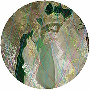
Satellite altimetry is an efficient tool in monitoring the level of enclosed seas, lakes and even large rivers. Since 1991, the Aral Sea is flown over - or was overflown - by a serie of altimetry satellites that measure the two seas antagonistic fluctuations.

 See the Aral Sea video: flash (10 Mo) or mpeg (32 Mo)
The Aral Sea is an enclosed sea in the heart of a geological depression in Central Asia, it is also very salty, shallow, in a semi-arid climate. These simple physical and geographical characteristics make it dependent of river systems that are pouring into it: the Amu Darya to the South of the "Large" Aral Sea and the Syr Darya to the North, on the "Small" Aral Sea. Other geopolitical characteristics have to be taken into account because three main countries share its resources: Kazakhstan and Uzbekistan are riparian countries while Turkmenistan is situated in its catchment area, on the upstream basin of the Amu Darya.
The area, the volume, the shorelines of the Aral Sea have declined since the mid-twentieth century, as a result of the large amounts of water diverted by intensive irrigation, including for cotton farming. This is not the first time the Aral Sea is drying up. Over geological time, tectonic movements and climatic phases have been also responsible for droping or significant rising levels. Over our contemporary period, in 1989, the Aral Sea has divided, for the first time. Since this time, we have been able to distinguish the Large Aral Sea to the south and the Small Aral Sea to the north. A 14-km long and 30-m wide dam was built in 1996 between the Large and the Small Aral Sea in order to keep waters in the northern basin. This physical boundary dooms the Large Aral Sea: its level drops inexorably, to the point where "Large" and "Small" words are becoming obsolete because, in turn, the Large Aral Sea is about to be divided in two, with two close basins, one shallow basin to the east, and another one deeper to the west. The South seems doomed, with a insoluble ecological disaster and some disastrous humanitarian conditions: beyond the lack of waters; deposits of salts, pesticides and fertilizers left by the sea and blown by the winds, are another heavy consequences for native population. In the North, results appear convincing after the construction of a second dam in 2005. The level is rising. Waters are back in deserted harbors, boats are launching, and if pollution is stopped, the hope is growing to see again nourishing fishing catches...
Although, the radar altimeter is not able to "take pictures" strictly speaking, as the optical or radar imagers satellites can do it, it is remarkable for being an efficient tool in monitoring the level of enclosed seas, lakes and even large rivers. Thus, each of the Aral Sea is flown over - or was overflown - by ERS-1, Topex/Poseidon, followed by ERS-2, GFO, Jason-1 and Envisat. Since 1991, this serie of satellites measure the two seas antagonistic fluctuations. Their task is not easy when the water recedes because the altimetry measurements accuracy can be degraded on heterogeneous surfaces.The new altimetry satellite, Jason-2, will ensure the continuity of the Aral Sea monitoring. With a new measurements processing algorithm onboard, it will be able to better define the land/water transitions and thus provide better accuracy.
Further information:
- Applications: <link internal-link>Aral Sea
- Image of the month:
- July 1999: <link internal-link>Aral Sea could be rising from the dust.
- November 2003: <link internal-link>Aral Sea: nothing new under the Sun
- Legos, Hydroweb, <link http: www.legos.obs-mip.fr soa hydrologie hydroweb page_2.html external-link-new-window>Aral Seas time series.
- <link http: www.aviso.oceanobs.com en newsstand links _top external-link-new-window>List of Aral Sea related-links


