


News
Altimetry applications in videos: Mediterranean Sea
Observations of the Mediterranean sea by means of in situ or satellite measurements are essential for monitoring, forecasting and managing it.
 See the video Mediterranean Sea: flash (11 Mo) or mpeg (48 Mo)
The historical and geographic dimensions of the Mediterranean Sea
On a geological scale, the Mediterranean sea was formed from the primitive Tethys ocean. During this period of major tectonic shifts, the closing of the straits of Gibraltar temporarily reduced it to a lake with a very high saline content. Historically speaking, the Mediterranean sea was first the cradle and then the crossroads of civilisations, shaping the routes taken for the Crusades, for Empires and for trade. In modern times, shipping routes have increased and population density on its shores has intensified both of which have directly weakened its ecosystems.
Even though it only accounts for 1% of the total surface of the oceans, it is itself a miniature ocean, although it differs in that the oceanographic phenomena occurring there are intensified by its partly closed basin. Incoming flow through the strait of Gibraltar provides most of the water which replenishes the Mediterranean basin through a circuit taking a hundred years, thus making up for evaporation loss, which rainfall and rivers alone would not be able to compensate. Geographically speaking, the geometry of the basin is relatively complex, with the shallows in the strait of Sicily separating the western and eastern basins. Plateaux, straits and islands divide these two basins into several distinct sub-basins, often characterized by their own spatio-temporal variability. From west to east, it is thus possible to sail on the Alboran Sea, the Balearic Sea, the Algerian Basin, the Liguro-Provençal Basin, the Tyrrhenian Sea, the Adriatic Sea, the Ionian Basin, which has the deepest areas (5,150 metres), the Aegean Sea and the Levantine Basin.
A new dimension : the Mediterranean Sea observed from Space
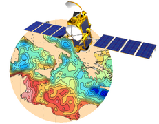
Observations of the Mediterranean sea by means of in situ or satellite measurements are essential for monitoring, forecasting and managing it. Radar altimetry determines sea height, by measuring the distance between the sea surface and the satellite and from this it is possible to deduce surface currents, the evolution of mean sea level, tides, wind speed and wave heights.
The sea level of the Mediterranean is subject to significant seasonal variations, due to it being an almost closed sea. Altimetry is used to measure its amplitudes, of the order of 20 cm, with a maximum level in October and November, a sharp drop in January and February and a minimum in March.
Analysis of altimetry data for the Mediterranean has now enabled, for the first time ever, characterisation of mean sea level while at the same time revealing regional differences : since the first measurements taken by Topex/Poseidon in 1992, the level of the eastern basin has clearly risen while that of the Ionian sea has dropped.
Altimetry measurements have also shown that some gyres, which until then had been thought to be permanent structures, actually have strong variability, even disappearing or 'migrating' for periods of time. This is true for the Alboran, Bonifacio, Pelops and Ierapetra gyres.
Our knowledge of the Mediterranean circulation system, while it has not yet been thoroughly defined (nor accepted) has increased greatly through satellite measurements. A significant change in circulation in the Ionian basin has been revealed by altimetry data: before 1997 the circulation in the north of this basin was anticyclonic, but it became cyclonic after 1997.
The altimetry satellite, Jason-2, launched in June 2008, came at just the right time to continue the time series of measurements and thus characterise the circulation system more accurately. The geometric layout of the Mediterranean basin, which includes many islands, limits the amount of reliable altimetry data, since their precision is in turn limited near the coast. Jason-2, which has a new algorithm for processing data on board, will improve the quality of measurements taken close to the coast. The later shifting of the Jason-1 satellite to an intermediary orbit will extend the constellation of currently-orbiting altimetry satellites with different spatial resolutions, thus enabling scientists to optimise investigations of smaller structures.
Further information :
- Applications : <link internal-link>Mediterranean Sea
- Ocean Indicator, <link internal-link>Mean Sea Level time serie and data selecting the Mediterranean Sea
- Pujol M.-I., 2006, "Analyse de la variabilité de surface en Méditerranée à partir des données altimétriques et comparaison aux simulations MERCATOR et MOG2D", These de l'Universite Paul Sabatier, Toulouse III.


