


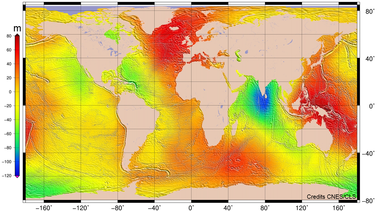
Mean Sea Surface description (MSS15)
The mean sea surface MSS_CNES_CLS_15 has been computed using a 20-year period of altimetry data.
Particular attention was paid to the homogeneity of the ocean content of this MSS, and specific processings were also carried out on data from geodetic missions. For instance, CryoSat-2, Jason-1 GM, and ERS-1 GM data were corrected from oceanic variability using results of optimal analysis of sea level anomalies (SLA).
The MSS CNES_CLS 2015 has been determined using a local least square collocation technique which provides an estimation of calibrated error. Our technique takes into account of altimetric noise, ocean variability noise and also along-track biases which are determined independently for each observation. Moreover, variable cross-covariance models are fitted locally for a more precise determination of the shortest wavelengths lower than 50 km. A specific data processings were used near the coast, the aim has been to preserve better continuity of the MSS accuracy from the open ocean to the coasts.
All these data have been preprocessed in order to be:
- more homogeneous, and referenced to 1993-2012 period (i.e. GDR standard in Duacs products),
- less contaminated by the ocean topography variable signal (the mean ocean topography signal contained in the surface is thus corresponding the mean sea level during the period 1993-2012).
The mean sea surface is corrected from seasonal variations and corresponds to the sum of geoid + mean ocean circulation.
The relief of this surface reveals:
- on a scale of thousands meters, undulations of hundred of meters due to differences in densities into the mantle;
- on medium wavelenghts, currents and water masses of varying densities, leading to sea level variations of several meters;
- on short wavelenghts, the heterogeneous distribution of matter concerning earth's surface layer and ocean's bottom topography, that implies geoid undulations of several meters.
The surface have been estimated on a 1/60 (1 minute) of a degree grid using a local inverse method, which also provides an estimation error field that is calibrated on the results of crossover point analysis of altimetric data.
This mean sea surface contains:
- Over ocean, the mean geoid plus the mean ocean dynamic topography (1993-2012),
- In continental areas (up to100 km inland): MSS is not defined
| Name | MSS_CNES_CLS15 |
| Reference ellipsoid | T/P |
| Reference time period | 1993-2012 (20 years) |
| Geographic coverage | Global (80°S to 84°N) - Oceanwide where altimetric data are available. |
| Spatial resolution | Regular grid with a 1/60° (1 minute) spacing (i.e. ~1.8 km) |
| Grid | 21600 points in longitude / 9811 points in latitude (-79.5°S to 84° N) |
| Method | Local least square collocation method on a 6' grid where altimetric data in a 200-km radius are selected. Estimation on a 1' grid based on (SSH minus First Guess) values (remove/restore technique to recover the full signal). The inverse method uses local anisotropic covariance functions that witness the MSS wavelength content. |
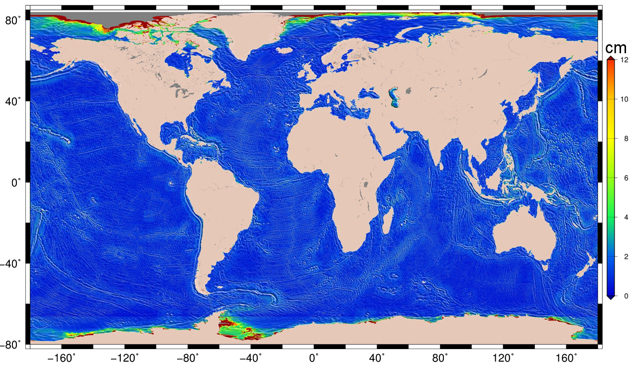
| Estimation error | YES (in cm) - The Optimal Interpolation method provides a calibrated formal error. |
Altimetric dataset
|
|
Mean Sea Surface description (Hybrid MSS SIO/CNES_CLS2015/DTU15)
This MSS corresponds to the MSS field which was selected for the production of L2p level altimetry data with DT-2021 standards, within the framework of the CNES (SALP) and Eumetsat (Copernicus Sentinel L2p / L3) projects. These products are used in the context of the corresponding DUACS (Data Unification and Altimeter Combination System) restatements.
The MSS is an important field that contributes to the quality of the DUACS products. The MSS thus
- Needs to be representative of the reference period chosen for SLA computation : [1993, 2012] for DUACS products
- Needs to resolve large and small scales (> ~30km), in open ocean and coastal areas
- Needs to be defined over all the oceans
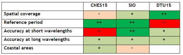
As different MSS models are available, all with some quality and default, a multi-model combined solution was computed, with the aims to benefit from the advantages of 3 different models.
This MSS was deduced from the combination of 3 different MSS reference fields over the ocean:
- The SIO MSS (Sandwell et al, 2017) was used over the open ocean.
- the MSS CNES_CLS15 (Pujol et al, 2016) was used un coastal areas (< 30km to the coast) and Antarctic region.
- the MSS DTU15 (Andersen et al, 2016) was used un Arctic region (latitude > 80 N).
The data used are describe below.
- MSS model : SIO
- Origin : SIO
- Reference : Sandwell D., Schaeffer P., Dibarboure G., Picot N., (2017). High Resolution Mean Sea Surface for SWOT. https://spark.adobe.com/page/MkjujdFYVbHsZ/
- MSS model : CNES_CLS2015
- Origin :AVISO+ https://www.aviso.altimetry.fr/en/data/products/auxiliary-products/mss.html
- Reference : Pujol, M.-I., Schaeffer, P., Faugère, Y., Raynal, M., Dibarboure, G., & Picot, N. (2018). Gauging the improvement of recent mean sea surface models: A new approach for identifying and quantifying their errors. Journal of Geophysical Research: Oceans, 123. https://doi.org/10.1029/2017JC013503
- MSS model : DTU15
- Origin : DTU https://ftp.space.dtu.dk/pub/DTU15/
- Reference : Ole Baltazar Andersen, G. Piccioni, L. Stenseng and P Knudsen. The DTU15 MSS (Mean Sea Surface) and DTU15LAT (Lowest Astronomical Tide) reference surface. https://ftp.space.dtu.dk/pub/DTU15/D
The Table below gives an overview of the quality and defaults of the different MSS models.
Documentation :
- For more information, please referre to the dedicated handbook
References :
- Andersen O., L. Stenseng, G. Piccioni, P. Knudsen, 2016. The DTU15 MSS (Mean Sea Surface) and DTU15LAT (Lowest Astronomical Tide) reference surface. ESA Living Planet Symposium 2016 - Prague, Czech Republic. http://lps16.esa.int/page_session189.php#1579p.
- Pujol M.-I., Schaeffer P., Faugere Y., Raynal M., Dibarboure G., & Picot N. (2018). Gauging the improvement of recent mean sea surface models: A new approach for identifying and quantifying their errors. Journal of Geophysical Research: Oceans, 123. https://doi.org/10.1029/2017JC013503.
- Sandwell D., Schaeffer P., Dibarboure G., Picot N., (2017). High Resolution Mean Sea Surface for SWOT. https://spark.adobe.com/page/MkjujdFYVbHsZ/."
| Name | Combined MSS SIO/CNES_CLS2015/DTU15 |
| Reference ellipsoid | WGS84 |
| Reference time period | 1993-2012 (20 years) |
| Geographic coverage | Global (79.5°S to 90°N) - Oceanwide where altimetric data are available. |
| Spatial resolution | Regular grid with a 1/60° (1 minute) spacing (i.e. ~1.8 km) |
| Grid | 21600 points in longitude / 10169 points in latitude (-79.5°S to 90° N) |
| Method | The methodology used to combine CNES15, SIO and DTU15 MSS models consisted in defining a transition band where a weighted mean is used to combine both the MSSs. |
| Estimation error | Not available |
Altimetric dataset
|
|
Data
- Products guide.
 Products .
- Sea surface height products .
- Value-added products .
- Wind/wave products .
- Auxiliary products .
- Sentinel-6 Level-2P skewness products.
- MSS .
- MDT .
- Global tide - FES.
- Coastal Tide - XTRACK .
- Internal tide - MIOST.
- Dynamic Atmospheric Correction using ERA5.
- Dynamic Atmospheric Correction dedicated to SWOT CalVal Phase .
- Dynamic Atmospheric Correction .
- Wet troposphere correction from water vapour climate data records.
- GPD+ Wet Tropospheric Correction.
- Slope correction for Sentinel-6A SAR altimetry.
- Range latitudinal empirical correction for Jason-1/2/3 GDR.
- References.
- Ice products .
- Ocean indicators products .
- Ocean data challenges .
- Tide Gauges products.
- Data access .
- Product information .
- CALVAL .