


Les zones côtières sont complexes avec de grandes variations de niveau d'eau, des problématiques économiques et écologiques majeures. L'altimétrie classique ne peut s'approcher au mieux (Saral) qu'à 5-10 km des côtes. Avec Swot, une réelle continuité depuis le plein océan jusqu'à la plage est possible, et ce avec une résolution de 250 m. Une résolution encore plus fine est fournie par les données traitées sur terres, à 3 km des côtes.
Estuaires
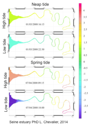
Les estuaires sont le point de rencontre entre la terre et la mer. L'hydrodynamique des estuaires est extrêmement complexe du fait des interactions entre les différentes eaux : la mer avec les mêmes phénomènes que les côtes (marées, vagues, surcôtes, élévation du niveau des mers) mais aussi le fleuve, ses affluents et les nappes phréatiques. Les modèles sont de plus en plus utilisées pour prévoir les débits, la qualité de l'eau et les déplacements de sédiments et polluants. Cependant, pour les définir mais aussi pour y assimiler des observations, il faut des mesures. Très peu d'estuaires ont suffisamment de marégraphes pour cela. Les mesures satellites permettent par contre de fournir des informations sur les variations spatiales de cette dynamique. Jusqu'ici, il était surtout question de couleur de l'eau, et de surveillance des sédiments et de la chlorophylle. Mais un certain nombre de facteurs, comme la turbidité, fluctuent considérablement avec les marées et le débit du fleuve avec des échelles de temps très variables. Leur modélisation nécessite donc la haute résolution apportée par Swot.
Près du littoral
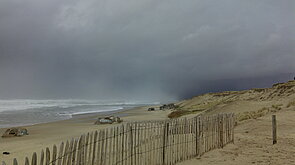
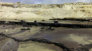
Les zones proches du littoral sont sujettes à une forte variabilité, et ce avec des échelles de temps et d'espace très variées, du fait de l'interaction entre marées, vagues, tempêtes, courants... Ces processus physiques, responsables de l'évolution de la morphologie des côtes, doivent être étudiée en détail pour prévenir les risques de submersion et les conséquences du retrait des côtes.
Les données in situ sont rares, là aussi. Dans le cas des côtes françaises, le réseau national comprend 63 marégraphes pour 3427 km de côtes. De plus, ils sont souvent situés dans des endroits abrités (ports). Pour palier ce manque de mesures, les modèles sont importants, mais difficiles à valider. Il y a donc un besoin d'observation de hauteurs de mer à des échelles temporelles et spatiales courtes pour valider et calibrer ces modèles. Les quelques marégraphes disponibles peuvent être couplés aux observations spatiales pour améliorer la couverture en hauteurs de mer dans ces environnements.
L'assimilation de données altimétriques classiques en haute mer, telle qu'utilisée aujourd'hui est problématique car elle laisse la bande littorale sans contrainte, et les principales erreurs sur le plateau continental peuvent venir des courants dus au vent. Des modèles combinant toutes les données disponibles sont en train d'être développés, mais l'absence d'observation de hauteurs de mer spatialement cohérentes dans la bande littorale reste un problème. Des paramètres en entrées des modèles de morphologie sont également nécessaires, modèles qui doivent être couplés aux modèles hydrodynamiques pour déterminer l'évolution des côtes.
La haute résolution de Swot fournit ces données. De plus, l'orbite du satellite a été choisie pour bien observer les huit principales composantes de la marées, ainsi que les composantes non linéaires près des côtes. La couverture globale permet d'étudier de nombreuses zones clés pour l'écologie ou l'économie, ainsi que les risques dus aux inondations, à l'élévation du niveau des mers et au retrait du trait de côte.
Sur le plateau continental
Le plateau continental est une région qui s'étend entre quelques dizaines à quelques centaines de kilomètres des côtes, coïncidant avec l'extension du plateau. L'intérêt pour la société de ces régions dérive de ses nombreuses utilisation : navigations, pêcheries, extraction de minerais, usages récréatifs... Ces activités font des zones de plateau un des points focaux de l'océanographie opérationnelle, nécessitant non seulement des observations, mais aussi des prévisions.
Dans ces régions, la pente de la bathymétrie aussi bien que la forme de la côte influence la circulation océanique, l'hydrographie et la biogéochimie. Les échanges entre l'océan profond, les plateaux et les zones littorales et estuaires sont également à prendre en compte. La dynamique sur le plateau peut être très compliquée, et les processus d'interaction peuvent créer des structures très énergétiques et rapidement changeantes, avec de fortes vitesses verticales.
La qualité première des données Swot est de produire des instantanés haute résolution de la hauteur de mer, variable primordiale, ainsi que des vents et vagues. La résolution des données sur le plateau est la même qu'en haute mer, 250 m, avec des incertitudes de l'ordre de quelques centimètres. L'échantillonnage Swot représente une innovation majeure et s'ajoute aux sources d'information nécessaires aux modélisations de la situation actuelle ainsi qu'aux prévisions des conditions océaniques pour cette vaste gamme d'activités.
Le défi est ici la combinaison de cette haute résolution spatiale avec une résolution temporelle plus basse. Aux hautes latitudes, il y a plusieurs observations d'une même zone durant le cycle de 21 jours (environ tous les 5 à 10 jours ; encore plus souvent aux hautes latitudes). Il n'est ainsi pas possible d'observer le développement des structures de petite taille que l'on peut repérer dans une image de la hauteur de mer à un moment donné. Plusieurs façon de contourner ce problème sont possibles.
Applications
 Océan .
- Applications côtières océaniques .
- Observations côtières à haute résolution.
- Acqua Alta à Venise.
- Glace et cryosphère .
- Climat .
- Atmosphère, vent, vagues .
- Géodésie et géophysique .
- Biologie .
- Navigation par zone géographique .