


Laser telemetry at Corsica calibration site
Laser telemetry
Laser telemetry has become the only space geodesy technique being at the same time, precise and absolute (exact distance measurement), continuously controllable on ground at the metrology level. This is due to its maintenance availability and its worldwide development.
- Jason-1, the first satellite from the Jason oceanography family developed by Cnes and Nasa, is the outcome of a sea state survey concept initiated several years ago with Topex/Poseidon (T/P). On a geodetic point of view, the expected variations of the mean sea level are about a millimeter per year; so long uninterrupted time series of oceanographic data are essential. In the same way, we expect, thanks to laser telemetry as well as other space techniques, a better knowledge of the orbit of altimetric satellites, and the determination of the Earth's crust displacements, including vertical motion, with the same precision level.
- The calibration of the on board altimeter radar is a key point for the validation of an altimetry mission [Ménard & al., 1994]. The time drift of an unexpected bias, due to electronic aging, is even more worrying for the analysis of secular mean sea level variations. The T/P mission experience has shown that is absolutely necessary to control this calibration at mm/year level over several years [Bonnefond et al., 2003a].
- Another major limitation of the altimetric system is related to the orbit determination quality, which is required to achieve the proper accuracy of the sea level determination in a geocentric reference frame. This because altimetry measurement is performed from a spacecraft.
This implies the use of global satellite tracking systems such Doris and / or GPS and outstanding numerical orbit processing methods in order to reach an orbit determination accuracy compatible with the centimeter level precision of data [Nouel & al., 1994]. Laser telemetry is the only absolute technique (the Doppler technique provides information on time varying distances) providing the essential scale factor with a constant quality even on intercontinental distances [Bonnefond & al., 1999]. The troposphere effects (moisture effects) are also much smaller than with radio-electric techniques.
In the frame of space oceanography like for space geodesy, it is a prime necessity to develop laser instruments with much more stable biases typically less than 5 mm over several years. Grasse is one of the 3 sites in Europe, reaching a sufficient accuracy for such measurements. It's a very interesting site that covers a large geographic area in the western Mediterranean Sea.
The economic interest to survey this area is evident, from a scientific point of view. The western Mediterranean Sea has become a unique calibration and experimentation zone in the world of the 90's beginning, due to its low oceanic variability as a quasi-closed Sea and its economical abilities. That's why we proposed to develop a double calibration site, in Grasse (Calern Plateau) and in Corsica (Aspretto naval base and Cap de Senetosa in the south).
Calibration campaign contribution
The experience of calibration/validation operations (Cal/Val) during the T/P mission has demonstrated the need to develop sites and ground experiments to control the instrumental drifts, which can occur on space altimeter equipment in-situ and along time.
We have a threefold experience in this field.
- First of all, precise orbit validations, with the development and the systematic use of a short arc orbit determination method based on laser telemetry data from a regional network [Bonnefond & al., 1995].
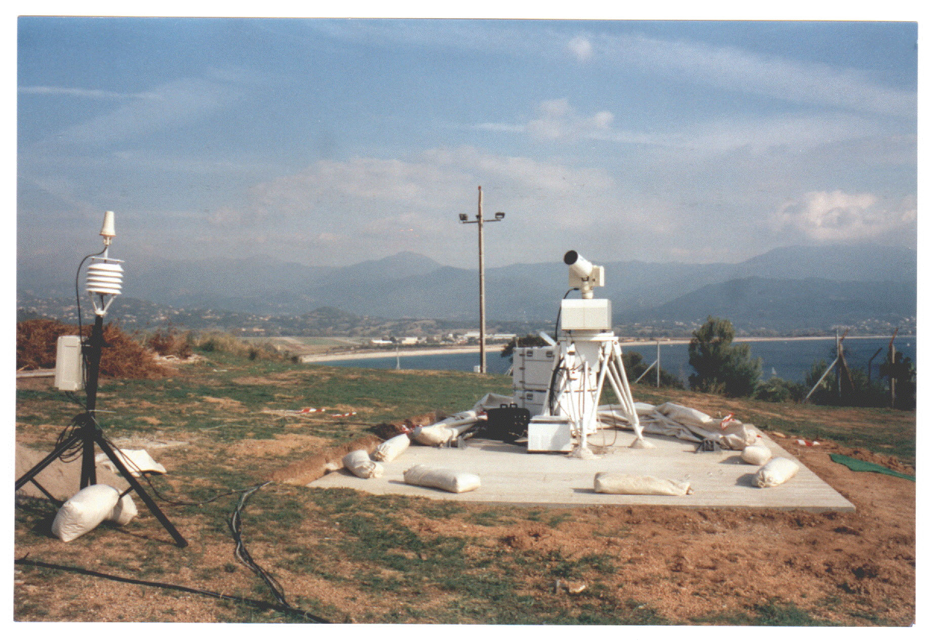
- Then, a calibration and collocation campaign in a new site in Corsica using the ultra-mobile laser station (FTLRS) operationally for the first time in1996/97, then during 2002 and 2005 campaigns. The station was also used in an international collaboration frame with a campaign in Creta in 2004, in support to Gavdos calibration site, and another in Tasmania in 2007-2008, in support to Burnie calibration site. The next FTLRS campaign is planned in Corsica after Jason-2 launch (June 2008).
- Finally, the laser instrumentals bias estimation over time, and its stability, which is a more and more important component for orbit determination and precise location in space geodesy [Bonnefond & al., 1999].
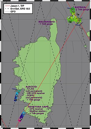
In the framework of the Jason program, we have proposed to Cnes and Nasa, a general error balance study of the orbit (tracking measurements, corrections, reference frame), and a double calibration campaign in Corsica (figure 1) and in Grasse with the ultra-mobile laser station and the fixed one of the Calern Plateau.
Corsica site
In Aspretto, main site located 2 km from Ajaccio:
- a GPS permanent site, installed by Cerga & IGN in 1999,
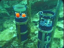
- a tide gauge permanent site (continuous ultra-sonic measurement), installed by Cerga & Epshom in 1999,
- a Doris station, will be installed by Cnes-Jason project beginning 2002,
- a laser campaign - FTLRS in 2002, with firings on Jason-1, T/P, and for positioning purpose on Lageos, (figure 2)
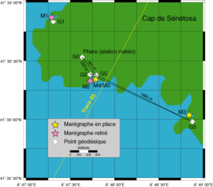
In Sénétosa, secondary site located at 40 km from Ajaccio (figure 3)
- Three tide gauges submerged on both sides of the Jason-1 - Topex n° 85 ascending track, installed by Cnes-Jason project, IGN, and Cerga since may 1998 (figure 4),
- A fundamental GPS reference point near the Sénétosa's lighthouse, with GPS survey ties and classical leveling for tide gauges: performed in 1998, and then every year for tide gauge survey ties by Cerga, Cnes and IGN,
- sea level measurements performed with GPS-buoys in the Sénétosa bay including survey ties of sea level with tide gauges performed by Cerga, Cnes and a JPL team, every year since 1998 [Bonnefond et al., 2003b].
Besides the two sites described above, several experiences realized these last years (2004 for Capraia and 2005 for Ajaccio) enable to do in Corsica a multi-satellite calibration (Topex/Poseidon, Jason-1 & 2, Envisat and GFO) over different dedicated sites (figure 1).
All the campaigns realized since Jason-1 launch thus enable to extend Corsica site calibration capabilities. In parallel, software and standards (based on IERS 2003 conventions) was updated in order to respond to the Topex/Poseidon and Jason-1 missions datasets, and prepare for Jason-1.
References
- P. Bonnefond et al., 2009, Absolute calibration of Topex/Poseidon, Jason-1 and Jason-2 altimeters in Corsica. OST/ST 2009 meeting, pdf
- Ménard, Y., et al., 1994, J. Geophys. Res. - T/P Special Issue
- Bonnefond, P., et al., 1995, J. Geophys. Res. - T/P Special Issue
- Bonnefond P., P. Exertier, F. Balier, 1999: Geographically Correlated Errors observed from a laser-based short-arc Technique, J. Geophys. Res
- Bonnefond, P., P. Exertier, O. Laurain, Y. Menard, A. Orsoni, G. Jan, and E. Jeansou, Absolute Calibration of Jason-1 and TOPEX/Poseidon Altimeters in Corsica, Special Issue on Jason-1 Calibration/Validation, Part 1, Mar. Geod., Vol. 26, No. 3-4, 261-284, 2003a.
- Bonnefond, P., P. Exertier, O. Laurain, Y. Menard, A. Orsoni, E. Jeansou, B. Haines, D. Kubitschek, and G. Born, Leveling Sea Surface using a GPS catamaran, Special Issue on Jason-1 Calibration/Validation, Part 1, Mar. Geod., Vol. 26, No. 3-4, 319-334, 2003b.