


Real time (RT) products
Timeliness is a critical element in the accuracy of (near) real time system such as Duacs[1]. Since Duacs v8.0, a new real time processing system based on OGDR was installed.
The general approach for integration of real time data sets in Duacs processing [2] is to extract from these data sets the short scales (space and time) which are useful to better describe the ocean variability in real time, and to merge this information with a fair description of large scale signals provided by the multi-satellite observation in near real time (read: current IGDR-based Duacs data). We're assuming that large scale signals have time decorrelation scales larger than the 2 or 3 day window of real time data (Jason OSDR and Envisat FDGDR, hereafter OGDR) used to complement the classical IGDR dataset.
Using the consolidated ground processing and the precise orbit determination available in NRT, plus the merging of all satellites, and the merging between NRT and RT, we are able to reconstruct an improved SSH measurement from the OGDR data.
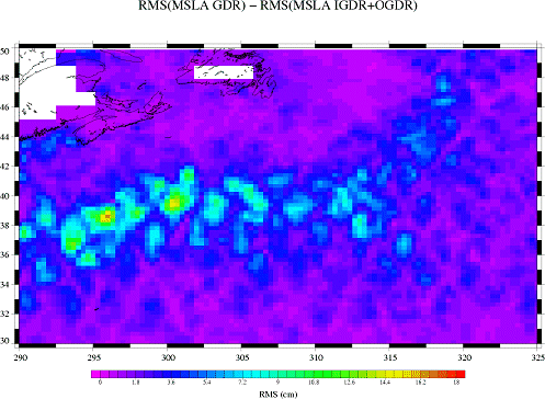
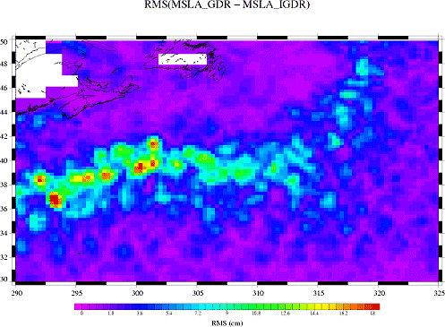
Recent results showed that the output product provides a significant improvement of the L3+ data sets generated by Duacs. Not only do we improve the mapping process as predicted by [1] and reduce the so-called NRT error by up to 30% in high variability regions, but we are also able to reduce the map production delay (read: compute a map only 3 days old, as opposed to the current 6 day delay from IGDR processing). Most importantly we are able to provide along-track data sets (Sea Level Anomaly and Absolute Dynamic Topography) based on real time geographical coverage. This translates into an additional 25 orbits of recent data available for assimilation in operational oceanography, and for real time applications (e.g: loop current monitoring in the Gulf of Mexico). The improved coverage and the delay reduction (from measurement to application) may prove useful for regional applications and/or real time applications on short time decorrelation scales events.
Another practical but significant side effect is that this processing can smooth out temporary unavailabilities observed frequently [3] in real time (onboard event, ground segment or network anomaly) by giving more data and a faster return to nominal status when the event is over.
[1] Ananda Pascual et al. Quality of real time altimeter maps: impact of data delay
[2] Gérald Dibarboure et al. SSALTO/DUACS : Daily multi-mission products for global and regional applications
[3] 45% of the Duacs productions of 2006 were carried out with missing/delayed/lost input IGDR data on at least one altimeter. In addition to classical operational events on the 3 altimeters (e.g: onboard memory event on Jason -> almost 3 weeks of data lost), Envisat was unavailable for many weeks due to anomalies on its ultra-stable oscillator, and GFO is now available only with a 50% coverage due to age degradation of its batteries.