


Jason-1 Calibration/Validation
B. Haines (NASA/JPL, USA), Y. Ménard (CNES, France)
The performance goals for the Jason-1 altimetric measurement system are very demanding. The Jason-1 calibration/validation (CALVAL) program is directed at providing post-launch assurance and verification that these goals are met or exceeded.
Jason-1 is the first in a series of planned radar altimeter missions designed to extend the remarkable TOPEX/POSEIDON (T/P) sea-level record [Fu et al., 1996; AVISO Newsletter 6, 1998] into the new millenium. Clearly, the Jason-1 measurement system must be held to the same performance standards established by its highly successful predecessor. In recognition of this, the Jason-1 measurement requirements were derived directly from estimates of errors in the current T/P science data products. These performance requirements are shown in Table 1 of the paper by Ménard and Fu [this issue], expressed in terms of an error budget for the determination of sea-surface height (SSH), and ancillary wind/wave parameters. The overall requirement on the single-pass accuracy of the SSH is 4.2 cm root-mean-square (RMS), commensurate with the current estimated performance of T/P.
Also given in the error budget table is a goal that elevates the expectations of Jason-1 performance to a new level. To achieve the goal for SSH accuracy (2.5 cm RMS), radial orbit errors must be reduced to 1 cm (RMS). Significant advances in the development of the correction terms for the altimeter range (e.g., sea-state and tracker effects) will also be needed. An additional goal (not listed) states that the measurement-system drift should not exceed 1 mm/yr. These goals have been developed in response to the challenge of "millimeter altimetry", driven by the unparalleled success of T/P. Meeting this challenge will enable new insight into subtle variations in the basin- and global-scale sea level which, despite their small magnitude, can significantly affect long-term climate change.
A principal objective of the Jason-1 CALVAL program is to verify that the post-launch performance of the measurement system meets or exceeds the standards set forth in the error budget requirements. An equally important goal is to calibrate the various component measurements in order to maximize the overall performance. To address these objectives, the CALVAL program will build on the successful T/P model by involving participants from the Jason-1 Science Working Team, as well as the CNES and NASA project offices. CALVAL efforts will peak during the six-month verification phase, which will begin when Jason-1 reaches its operational orbit approximately one month after the launch. During this phase, Jason-1 and TOPEX/POSEIDON will fly in a tandem arrangement to enable ultra-precise cross-calibration of measurements from the two satellite systems. At the end of the verification phase, the CALVAL team will issue a revised error budget as well as estimates for the bias and drift of the measurement system in an absolute sense and in relation to the T/P system. Recognizing the importance of ongoing validation to achieving the measurement goals of the mission, many of the CALVAL activities will continue for the duration of the mission. This continual monitoring will be essential to our quest to achieve "millimeter altimetry".
CALVAL implementation
The Jason-1 CALVAL program embraces a wide variety of activities ranging from engineering assessments of the sensor data to in situ validation of the overall measurement system. CNES will monitor engineering and science data from the POSEIDON-2 altimeter (POS-2) on an ongoing basis to ensure that all performance requirements (e.g., noise, range drift) are being met. Like its predecessors on TOPEX/POSEIDON, the POS-2 altimeter has two internal calibration modes: one provides a measure of the point target response of the instrument, and the other measures the altimeter transfer function. CNES will monitor how output from these calibration modes evolves in the long term, and the results will be accounted for in routine science data processing. Jason-1 science-team investigators from NASA Wallops Flight Facility, responsible for monitoring the TOPEX radar altimeter, will also participate in the POS-2 internal calibration exercise. Science team investigations will target improvements in the sea-state and electromagnetic biases, which corrupt the altimeter range measurements. Finally, the dual-frequency ionosphere correction from POS-2 will be validated using estimates derived independently from GPS and DORIS.
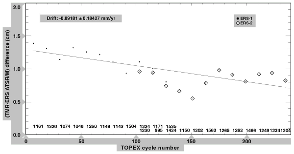
The three-frequency Jason microwave radiometer (JMR) provides an estimate of the columnar water-vapor delay used to correct the altimeter range. When operating nominally, the JMR does not employ a "cold-sky" calibration mode; rather it relies on triple-redundant (noise-diode) temperature measurements on each of the three operating frequencies. The JMR engineering team at the Jet Propulsion Laboratory (JPL) will monitor and ensure the integrity of the noise-diode and antenna temperatures on an ongoing basis. Jason-1 science team investigators will perform intensive post-launch calibration of the JMR brightness temperatures and path-delay retrieval algorithms using ground truth as well as comparisons with data from other spaceborne radiometers and global models (Figure 1). The path-delay measurements will be monitored throughout the mission to detect potentially subtle drifts, such as the 1 mm/yr trend experienced by the TOPEX microwave radiometer [Keihm et al., 1999]
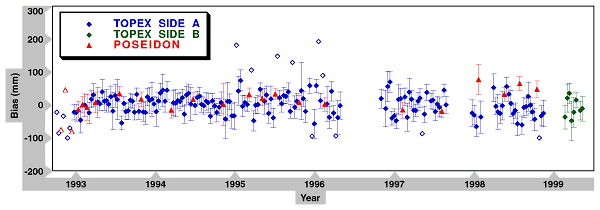
In situ validation of the overall measurement system will be performed using dedicated verification sites, as well as distributed tide gauges. The principal objective of these programs is to use observations from tide-gauges directly on (or near) Jason-1 ground tracks to calibrate the SSH measurement made by the satellite as it passes overhead. Dedicated verification sites offer the advantage of a direct overflight geometry, and an absolute tie to the geocenter. In addition, they typically feature several collocated sensors (e.g., tide gauges, radiometers, GPS and SLR) to help discriminate between different sources of error. The prime CNES verification site is located on the island of Corsica [Exertier et al., this newsletter]. Set up in 1996, the Corsica experiment is currently delivering ground-truth data to support calibration of T/P, which traces out the same ground track as that planned for Jason-1. Pelagic GPS techniques have been recently used to measure the geoid slope between the locations of the open-ocean altimeter measurements and the coastal tide gauges at the principal Cape Senotosa site. An extension of this program to Capraia island, located between Corsica and Italy, will provide an additional verification opportunity along the same satellite track. The prime NASA verification site for T/P is located at the Harvest oil platform off the coast of central California [Christensen et al., 1994]. A T/P calibration time series dating back to the satellite’s 1992 launch has been formed from the Harvest data, and the potential systematic in-situ error sources have undergone extensive evaluation (Figure 2). The calibration program for Jason-1, which will also fly directly over the platform, will benefit significantly from the occupation history at this site [Haines et al., 1998]. Successful T/P altimeter calibration sites in the Bass Strait [White et al., 1994] and English Channel [Murphy et al., 1996] will also continue to provide data for the Jason-1 CALVAL effort. Finally, plans are under way to develop additional sites in the Mediterranean and Gulf of Mexico to support calibration of multiple altimeter missions, including ENVISAT and Geosat Follow-On in addition to Jason-1 and T/P.
While the information from the absolute calibration proved invaluable for detecting biases in the TOPEX/POSEIDON measurement systems, the most reliable external information on system drift was afforded by the global tide-gauge network. Cooperating tide gauges in this network are rarely found along the satellite's ground track; moreover, only a few are presently equipped with GPS or DORIS to provide information on vertical land motion. When determining the stability of the altimeter measurement system; however, these limitations can be overcome by combining calibration time series from the many distributed tide gauges into a single ensemble result [Mitchum, 1998]. The resulting drift estimate provides information that is complementary to the calibration estimates from the dedicated sites. The significance of this complementary information was amply demonstrated with the discovery in 1996 of a TOPEX algorithm error which introduced both a global bias (13 cm) and slow drift (8 mm/yr) in the sea-surface heights. While the effects of the mean component of the error were readily observed by the dedicated calibration sites soon after launch [Christensen et al., 1994; Ménard et al., 1994; White et al., 1994; Haines et al., 1998], a multi-year calibration time series from the global tide-gauge network was needed to convincingly detect the slow drift [Mitchum, 1998]. In retrospect, the combined results provided a remarkable portrait of the total effect of the algorithm error on the sea-surface height. This experience helped spur efforts to further enhance the global network by identifying 30 selected tide gauges where vertical land motion measurements are needed to support improved altimeter stability estimates [e.g., Mitchum, 1997]. As part of a Jason-1 science team investigation, the University of Hawaii Sea Level Center has embarked on a program to provide continuous GPS at 7 of the 30 gauges comprising the altimeter calibration network. Some of the remaining stations are already instrumented with GPS or DORIS; thus a major component of the enhanced network will be in place for the May, 2000, launch of Jason-1.
In addition to the external (in situ) calibrations, the CNES and NASA project elements will be performing routine, global evaluations of data generated by the science data processing systems for both Jason-1 and TOPEX/POSEIDON. Such statistics (e.g., histograms, spectra, multi-variable mapping, cross-over residuals, multi-satellite comparisons) are essential to quickly check the quality and consistency of geophysical products. They are generated every ten days and sent to experts for further analysis [Dorandeu, this issue]. Science working team members will participate in more specialized characterizations of these global data sets.
Significant efforts will also be devoted to verifying the precise estimates of the radial orbit positions. A precise orbit determination (POD) verification team-led by the University of Texas and consisting of selected members of the science team and CNES/NASA representatives-has been formed to evaluate and exchange existing models and iterate on recommendations for standards to be used by CNES in computing the orbits. Extensive post-launch validation will be performed by comparing orbits determined by various contributing groups using different data and strategies (e.g., reduced-dynamic GPS, short-arc laser, DORIS). On-going verification and continuous improvement will be essential if the goal of 1 cm for the radial orbit accuracy is to be attained.
Concluding remarks
The CALVAL plan for Jason-1 will involve many project- and science-team experts who share the motivation to characterize and improve Jason-1 system performance. The TOPEX/POSEIDON experience has highlighted the benefit of wide participation in CALVAL activities spanning engineering assessment through scientific evaluation. The Science Working Team in particular plays an essential role in these efforts.
Coordination of the CALVAL activities and synthesis of results will require close interaction among the participants. A meeting dedicated to verification will be held a few months after the launch. In addition, results and analyses will be presented at regular SWT meetings. These meetings will also provide a forum for issuing recommendations that will serve as the basis for updating the post-launch error budget and the algorithms underlying the science data processing.
In addition to monitoring the performance of the measurement system, the CALVAL team will attempt to refine the error budget in such a way as to characterize long-term sea-level changes (inter-annual to secular) to within a few millimeters per year. Achieving the error-budget goals, measuring the bias and drift of the measurements at the millimeter level, and ensuring a precise connection with previous and future altimetric missions are the keys to meeting this "millimeter challenge".
References:
- AVISO Newsletter 6, 1998
- Christensen, E.J., et al., 1994: Calibration of TOPEX/POSEIDON at Platform Harvest, J. Geophys. Res. 99(C12), 24,465-24,485.
- Dorandeu, J., 1999: AVISO CALVAL Activities, AVISO Newsletter 7.
- Exertier, P. et al., this newsletter, 1999.
- Fu, L.-L., C.J. Koblinsky, J.-F. Minster, J. Picaut, 1996: Reflecting on the first three years of TOPEX/POSEIDON, EOS Trans. 77(12), 109.
- Haines, B.J., G.H. Born, E.J. Christensen, S. Gill, D. Kubitschek, 1998: The Harvest Experiment: TOPEX/POSEIDON absolute calibration results from five years of continuous data, AVISO Altimetry Newsletter 6: TOPEX/POSEIDON: 5 Years of Progress, 53-54.
- Keihm, S.J., V. Zlotnicki, C.S. Ruf, 1999: TOPEX Microwave Radiometer performance evaluation, 1992-1998, IEEE Trans. Geosci. Remote Sensing, (submitted).
- Menard, Y., E. Jeansou and P. Vincent, Calibration of the TOPEX/POSEIDON altimeters at Lampedusa: Additional results at Harvest, J. Geophys. Res. 99(C12), 24,487-24,504, 1994.
- Menard, Y., L.-L. Fu, 1999: Jason-1, on the tracks of TOPEX/POSEIDON, AVISO Newsletter 7.
- Mitchum, G., 1998: Monitoring the stability of satellite altimeters with tide gauges, J. Atmos. and Oceanic Tech. 15(3), 721-730.
- Mitchum, G., 1997: A tide-gauge network for altimeter calibration, Methods for Monitoring Sea Level: GPS and tide gauge collocation and GPS altimeter calibration: Proceedings from IGS/PMSL workshop, Jet Propulsion Laboratory Publication 97-17, 45-55.
- Murphy, C.M, P. Moore, P. Woodworth, 1996: Short-arc calibration of the ERS-1 and TOPEX/POSEIDON altimeters utilizing in situ data, J. Geophys. Res. 101(C6), 14,191-14,200.
- White, N.J., R. Coleman, J.A. Church, P.J. Morgan, S.J. Walker, 1994: A southern hemisphere verification for the TOPEX/POSEIDON satellite altimeter mission, J. Geophys. Res. 99(C12), 24,505-24,516.
News
 Archives .
- Aviso Newsletter .
- Newsletter 1 .
- Newsletter 2 .
- Newsletter 3 .
- Newsletter 4 .
- Newsletter 5 .
- Newsletter 6.
- Newsletter 7 .
- Jason-1, after T/P.
- Jason system overview and status.
- Ssalto, new ground segment.
- Review of 1999 and future AVISO activities.
- Jason-1 Calibration/Validation.
- Absolute altimeter calibration in Corsica.
- AVISO CALVAL Activities.
- Multi-variate assimilation to initialize El Niño predictions.
- Investigation at regional scales of sea level variability.
- Assimilating TOPEX/POSEIDON data to better understand Warm Pool replenishment and depletion.
- Further details of the 1997-98 El Niño.
- TOPEX/POSEIDON and TAO: Comparative simulation.
- Newsletter 8.
- Newsletter 9.
- Newsletter 10.
- Search.
- Front-page news.
- Image of the month .
- Operational news and status .