


Jason-1, on the tracks of Topex/Poseidon
Y. Ménard (Cnes, France), L. Fu (Nasa/JPL, USA)
The exceptional results obtained from Topex/Poseidon (T/P) [see Fu et al., 1996; Aviso newsletter n°6, 1998] soon convinced the scientific community of the need for a follow-on mission. As T/P has demonstrated, high-accuracy radar altimeter missions are the ideal tool for observing the global ocean circulation to help us better understand its short- and long-term variations and its impact on climate.
Soon after the launch of Topex/Poseidon (T/P) in August 1992 and following a comprehensive analysis of system performance, the Science Working Team (SWT) strongly recommended that such a mission should be maintained in the long term. Early in 1993, Cnes and Nasa started a new cooperative project on a follow-on satellite, called Jason-1. The main motivation was to continue measuring the sea surface topography with at least the same level of accuracy as T/P. The superb performance the T/P mission has achieved owes much to the efforts made to optimize the system: the instruments, satellite, and orbit parameters were all specifically designed to fulfill the mission objectives. Jason-1 is adopting the same philosophy, building on the T/P heritage but with a smaller satellite to reduce costs. Applications relying on data available in near-real time are also one of the mission’s main objectives. Jason-1 will thus help to prepare and deploy ocean observing and prediction systems in the years ahead through major international programs.
Scientific objectives
The mission's scientific objectives are derived mainly from the T/P experiment return [Fu et al., 1996; AVISO Newsletter 6, 1998] and were defined with the assistance of the SWT:
Mean ocean circulation
T/P has made a significant contribution to the description and characterization of the main features of ocean circulation, i.e., the location of the main currents, their intensity, transport, and interaction with transient phenomena. Characterizing the mean ocean circulation using altimetry data is vital to improve our understanding of the underlying physics and to model the phenomena involved, so that we can refine ocean circulation models. However, our knowledge of the "mean" ocean is still limited by our lack of understanding of the short scales of the current reference level, i.e., the geoid. Satellites soon to be launched to study the Earth's gravity field (CHAMP in 2000, GRACE in 2001, and GOCE in 2003) will largely fill this gap in our knowledge. These missions will provide data that, combined with altimetry measurements, will greatly improve our ability to map and monitor mean ocean circulation and to provide better-quality input for assimilation in ocean models.
Intra-seasonal to inter-annual variability
This ocean variability has a big effect on climate changes. Corresponding ocean signals were especially difficult to detect using early altimetric data, as they were masked by large orbit errors. The T/P mission marked a turning point in this respect due to its greater measurement accuracy and a significantly reduced error for orbits determined using the Doris system. Moreover, the orbit cycle (10 days) was chosen to offer an appropriate time-space sampling. Jason-1 will continue in exactly the same orbit. Large-scale intraseasonal sea level variability (10 to 100 days), which does not exceed a few centimeters, is mainly driven by oscillations that are coherent over thousands of kilometers and are a direct response to high-frequency wind forcing. Other oscillations at periods longer than 100 days are due to propagation of Rossby waves across the ocean basins. Measurement of propagation speeds using T/P observations led to a revision of existing theory about such waves. Large intra-seasonal variations also have been detected in the western boundary currents (Kuroshio, Gulf Stream).
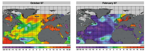
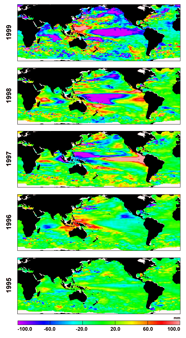
At seasonal scales, the annual cycle (Figure 1) is the result of close but complicated interactions between the ocean and the atmosphere (solar radiation changes, heat fluxes, wind forcing, etc.). T/P observations have improved characterization of this seasonal cycle and its geographic dependence, which is essential for evaluation and first-order adjustments of ocean and climate models. Amplitude of the seasonal signal can reach 15 cm in some areas, but it may vary significantly from one year to the next because of inter-annual changes. "El Niño" events, including the strong 97-98 event in the tropical Pacific, are dramatic examples of such inter-annual anomalies corresponding to strong ocean-atmosphere interactions. Other inter-annual events have been detected with T/P (as in the Atlantic in 1995) and longer-period signals (5 years and more) are also observable now. This wide range of variability modes makes them particularly hard to understand. But modeling and predicting these phenomena is one of the keys to improve climate forecasting. Assimilation of altimetric data and other types of data in ocean-atmosphere coupled models will play a central role in this domain. This fact highlights the need for long time series of altimetric data with the same characteristics and quality as T/P.
Mesoscale and coastal variability
The so-called "mesoscale" signal has typical spatial scales of 30 to 300 km and time scales of one to three months. It is associated with short-period flow variations and movements of ocean currents, and with the formation and propagation of very energetic ocean eddies. These eddies, which play a key role in heat transport from low to high latitudes, are generated by mean flow instabilities and/or interactions with submarine topography. They are present everywhere but they are particularly numerous in the vicinity of intense currents, i.e., the Gulf Stream, Kuroshio Current, and Antarctic Circumpolar Current. The way this mesoscale energy is distributed was revealed in global variability maps, which were among the first results obtained by altimetry. The maximum variability can reach more than 40 cm (near strong currents), while the minimum of less than 3 cm is still significant in regions of low variability. Only T/P-quality data can provide the accuracy required to detect and monitor such weak signals.
The coastal domain represents 8% of the ocean surface. Fisheries and offshore oil drilling activities are mainly concentrated in these areas. It is a complex and fragile domain influenced by many factors, such as the accumulation of organic matter and fresh water transported by rivers, the action of sea ice at high latitudes, coastal tides, and interactions between coastal currents and open ocean circulation. Altimetry data are useful for resolving mesoscale and coastal variability. However, we need to achieve better sampling by merging, in an optimal way, different altimetric data sets such as T/P and ERS2 or Jason-1 and Envisat in the future.
Mean sea level trend
Mean sea level is a good indicator of global warming. Because of thermal expansion, when temperature increases the ocean occupies a larger volume. A one-degree rise in temperature over a depth of one hundred meters is enough to increase the sea level by a few centimeters. Another additional and important cause of sea level rise is ice melting. If such a rise was to continue for a hundred years, it would have dramatic socio-economic and environmental consequences. T/P data (see figure 3 in J. Dorandeu et al. in this newsletter), thanks to their exceptional time-space coherence, have confirmed this trend already observed by tide gauges (about 15 cm over the past hundred years). However, this signal represents only 1-2 millimeters per year, so we must exercise extreme caution when interpreting the results derived from T/P, as detecting such a small signal is very difficult. This will be one of the goals for Jason-1, which will require millimeter-level control on the potential drifts of the altimetric system components (altimeter, radiometer, orbit, system reference, etc.). To reduce the error in sea level trend estimation, we will also need to obtain altimetric observations over several decades and to establish a precise interconnection between successive satellite time series.
Tides
Thanks to T/P data, several ocean tide models of unprecedented accuracy (2-3 cm rms) have been produced for the main diurnal and semi-diurnal components. These results have significantly improved corrections to altimetric data for tide effects. A closer understanding of tides (by direct analysis of T/P data or by assimilating them into hydrodynamic models) is the result of the high quality of the T/P data set. It is also the consequence of the space-time sampling, i.e., the phasing of the T/P orbit, optimized to discriminate the various tide components. Accumulating more data beyond the T/P mission will enable us to fully resolve the long-period ocean tides as well as the unfavorably aliased constituents (such as K1, aliased close to the semi-annual period). In coastal regions, merging Jason-1 and Envisat data will greatly enhance our ability to resolve short-scale tide signals.
Sea State
In addition to range, altimetry measurements provide estimates of significant wave height and wind speed (derived from sigma-naught), which are of scientific and operational interest in marine meteorology. From a climatological point of view, altimetric measurements in regions where conventional observations are especially sparse provides a basis for comprehensive studies of sea state parameters, providing precise information on their time-space characteristics and their variations at intra-seasonal to inter-annual scales. Additional studies are focusing on propagation of swell and interactions between sea state and currents. Such studies are essential to improving meteorological models for more reliable forecasting. Adjusting these models by assimilating near-real time altimetry data will further improve forecasts. A number of weather services are already feeding altimetry data into their operational models. They will thus reap the benefits of wind-wave data supplied by Jason-1 in near-real time (under five hours).
Others issues in geodesy, geophysics, glaciology and hydrology
Altimetry measurements of sea level height are a first-order representation of the marine geoid signal, which is a result of gravitational forces acting on the ocean, because of its much larger amplitude (10 to 100 times more) compared to the ocean dynamic topography. After filtering variable ocean signals, detailed maps of the marine geoid have been obtained using high-density Geosat and ERS altimeter data. T/P data, despite a less appropriate spatial sampling, have generally been used as the reference data set for adjusting other satellite data sets. Geophysicists can thus obtain a great deal of information on short-wavelength tectonics (10 to 500 km) in these altimetric mean sea surfaces. They can also extract other relevant information by processing trajectography data in an appropriate fashion. T/P orbits and positions of ground tracking stations are determined very accurately using DORIS, GPS and laser data. Such observations have a very beneficial impact on reference system quality and derived parameters such as the Earth’s rotation, measurements of vertical displacements of stations, glacial rebound, and atmospheric or oceanic load effects. Determining these movements with the required millimeter accuracy is essential to distinguish them from sea level rise determined from altimetry and/or tides gauges. Other interesting results have been obtained from T/P data by scientists studying sea ice, enclosed seas, lakes, large rivers and flat continental topography despite inadequate technical design and orbit geometry for such applications. These applications are usually based on altimetric waveform retracking (reflection characteristics are not the same as they are over the open ocean). Combining T/P and future Jason-1 positioning and range data with other satellite data (i.e. ERS and Envisat) with higher spatial sampling will greatly improve spatial resolution, which is essential for such applications.
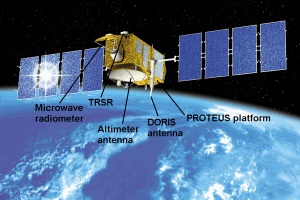
Figure 3: An artist view of Jason-1 satellite on orbit
Performance and Data
The Jason-1 mission was defined to achieve optimum continuation of the T/P scientific mission and to satisfy long-term observation requirements, as mentioned previously. The satellite, to be launched end of 2000, has a minimum design lifetime of three years, with the potential for an additional two years. Every 10 days, it will overfly the reference T/P ground-tracks within 1 km, measuring sea level with the same accuracy as T/P or better. The requirements in terms of the error budget are summarized in table 1. The Geophysical Data Record (GDR) requirements are similar to the post-launch T/P GDR error budget. The satellite, including the dual-frequency altimeter, three-frequency radiometer, and the Doris and GPS Precise Orbit Determination systems, has been designed to meet these requirements. Sea surface height will be measured with a global and ultimate rms accuracy of 4.2 cm (one sigma) over one second averages along T/P ground-tracks. This error budget includes altimeter noise, uncertainties in corrections for atmospheric path delays (ionospheric and tropospheric corrections), sea-state related biases, and orbit error. The Interim GDR (IGDR) error budget is the same as the GDR, except that the orbit is not fully validated in the IGDR. In addition to these requirements, specific goals have been established with respect to expected off-line ground processing improvements, the aim being to reduce the error to 2.5 cm rms for the sea level height over a one second average. System drift (after calibration) shall not exceed 1 mm/year to meet the requirement for monitoring of the mean sea level trend.
GDRs will constitute the final and fully validated product. They will be systematically delivered to data users within 30 days and archived as permanent records. They will contain, at a rate of one record per second, the best estimates of range, time tag and earth location, plus the best associated instrumental and environmental corrections and the most accurate orbit altitude. All these parameters will be validated during the verification phase of the mission during the first six months after launch. GDRs, structured in a way similar to T/P, will contain additional geophysical parameters, i.e., wave height, sigma-naught and derived wind speed, atmospheric surface pressure, tides, mean sea surface and geoid. The altimeter radar instrument bias and drift and the relative bias between T/P and Jason-1 time series will be provided. For specific applications (over coastal areas, lakes, land or ice), Sensor Geophysical Data Records (SGDRs) containing waveforms will be made available to users.
| OSDR 3 Hours | IGDR 3 days | GDR 30 days | GOALS |
Altimeter noise
| 2.5 (a)(c)(d) | 1.7 (b)(c)(d) | 1.7 (b)(c)(d) | 1.5 (b)(c)(d) |
Ionosphere
|
| 0.5 (e)(d) | 0.5 (e)(d) | 0.5 (e)(d) |
EM Bias
| 2 (f) | 2 (f) | 2 (f) | 1 |
Tracker Bias
| 2 | 1 (g) | 1 (g) | 0.2 (g)
|
Skewness
| 2 | 1 (g) | 1 (g) | 0.2 (g)
|
Dry troposphere
|
| 0.7 | 0.7 | 0.7 |
Wet Troposphere
| 1.2 | 1.2 | 1.2 | 1 |
|
|
|
|
|
Altimeter range RSS |
| 3.3 | 3.3 | 2.25 |
RMS Orbit (Radial component) | Spec: 30 (h)
| < 4 | 2.5 | 1 |
|
|
|
|
|
Total RSS sea surface height
|
| 5 | 4.2 | 2.5 |
Significant wave height
| 10% or 0.5m (i) | 10% or 0.5 m (i) | 10% or 0.5 m (i) | 5% or 0.25 m (i) |
Wind speed
| 2 m/s | 1.7 m/s | 1.7 m/s | 1.5 m/s |
Sigma naught (absolute) | 0.7 dB | 0.7 dB | 0.7 dB | 0.5 dB |
Table 1: Jason-1 error budget specifications (in centimeters)
(for one-second average, SWH 2 meters, sigma naught 11 dB)
(a) Combined Ku + C measurement (d) Assuming 320 MHz C bandwidth (g) After ground retracking, (b) Ku band after ground retracking (e) Filtered over 100 km (h) Real-time DORIS onboard ephemeris, (c) Averaged over 1 s (f) Can also be expressed as 1% of H1/3 (i) Whichever is greater
IGDRs and Operational Sensor Data Records (OSDRs) will support near-real time applications, including mesoscale and coastal applications, climate forecasting and marine meteorology. Mesoscale signal monitoring and forecasting have specific applications in domains like fisheries, marine fauna survey, oil drilling, commercial navigation and defense. Prediction of El Niño type events is an important issue because of their impact on the Earth’s climate and consequently on economic and social conditions in the countries affected. Forecasting of wind speed and significant wave height (SWH) is of interest to many activities related to maritime industries. The key requirement for operational use of altimetric data in models is to provide the data very quickly. IGDRs will be delivered within three days, mainly for mesoscale and climate applications. They will contain the same parameters as GDRs, but not fully validated and not necessarily in their ultimate precision. OSDRs will be provided within three hours, mainly for marine meteorology applications. They will contain, at a rate of one record per second, all the parameters needed for such applications. OSDRs products will have a lower accuracy than IGDRs (table 1) as they are based on onboard processing of radar and orbit Doris measurements (the Diode orbit), but they will fully satisfy the real-time objectives.
Conclusion
Following the successful Topex/Poseidon mission, Jason-1 will continue to support the research activities needed to improve our understanding of the ocean circulation and its interaction with climate. As Jason-1 is a key component of programs like Mercator, Godae and Goos, dedicated to the observation and modeling of the global Ocean, it will also mark the beginning of a new era in operational oceanography. The continuation of such missions beyond 2004 is widely supported by the user community. The Jason-2 missions is already being proposed and has to be decided within next months to pursue the needed high-accuracy altimetric ocean observation from space.
References:
- Aviso Newsletter 6, 1998.
- Fu, L.L., C.J. Koblinsky, J.F. Minster, J. Picaut, 1996: Reflecting on the first three years of Topex/Poseidon, EOS Trans.77 (12), 109.
News
 Archives .
- Aviso Newsletter .
- Newsletter 1 .
- Newsletter 2 .
- Newsletter 3 .
- Newsletter 4 .
- Newsletter 5 .
- Newsletter 6.
- Newsletter 7 .
- Jason-1, after T/P.
- Jason system overview and status.
- Ssalto, new ground segment.
- Review of 1999 and future AVISO activities.
- Jason-1 Calibration/Validation.
- Absolute altimeter calibration in Corsica.
- AVISO CALVAL Activities.
- Multi-variate assimilation to initialize El Niño predictions.
- Investigation at regional scales of sea level variability.
- Assimilating TOPEX/POSEIDON data to better understand Warm Pool replenishment and depletion.
- Further details of the 1997-98 El Niño.
- TOPEX/POSEIDON and TAO: Comparative simulation.
- Newsletter 8.
- Newsletter 9.
- Newsletter 10.
- Search.
- Front-page news.
- Image of the month .
- Operational news and status .