


SSALTO: a new ground segment for a new generation of altimetry satellites
S. Coutin-Faye, J. Noubel, G. Boutonnet (CNES, France)
CNES is developing a new-generation ground segment in preparation for Jason and ENVISAT, the next two major satellite altimetry missions. Called SSALTO, this ground segment is scheduled to take over progressively from the DORIS/POSEIDON ground segment in readiness for Jason in 2000 and ENVISAT in 2001.
The ground control and processing segment for the DORIS and POSEIDON instruments (SSDP) came on stream at the beginning of the 1990s to meet the needs of the DORIS/Spot (Spot 2, Spot 3 and Spot 4) and TOPEX/POSEIDON (T/P) programs. The SSDP has continued to operate throughout the decade, supported by the AVISO User Service, which recently started offering users access to T/P archive data through an online catalog.
Today, we need a single ground segment for the DORIS/Spot, DORIS/ENVISAT, TOPEX/POSEIDON, Jason and ENVISAT missions to satisfy users’ common needs, and to continue operating new DORIS instruments and altimetry payloads that will be flying simultaneously on different satellites in the near future.
The new SSALTO multi-mission altimetry, orbit determination and location ground segment (Segment-Sol multi-missions d’ALTimétrie, Orbitographie et localisation précise), developed by CNES with its subsidiary CLS and its regional industry network, will meet these needs. SSALTO will also support a broad range of altimetry expertise for the ERS-1 and ERS-2 missions, and ultimately for the GEOSAT Follow-On mission (GFO).
SSALTO will enter service for the launch of Jason. Functions currently performed by the SSDP will progressively switch over to SSALTO.
SSALTO will provide the ground facilities for:
- control of DORIS and POSEIDON instruments, and of the DORIS ground orbitography beacon network;
- processing of data acquired by DORIS payloads on Spot and ENVISAT, and by altimetry payloads on TOPEX/POSEIDON, Jason-1 and ENVISAT;
- user services for all SSALTO mission products, altimetry expertise for the above missions and for ERS-1 and ERS-2 altimetry missions, and ultimately GFO.
SSALTO user projects
The DORIS/Spot family that entered service with the launch of the DORIS instrument on Spot 2 has been performing operational precise location since 1990, helping also to determine the International Terrestrial Reference Frame. Since 1998, DORIS and the DIODE navigator on Spot 4 have provided onboard, operational orbit determination. The DORIS instruments on Jason, Spot 5 and ENVISAT will also provide this function.
The objective of the joint French-US TOPEX/POSEIDON and Jason missions is to measure ocean topography.
TOPEX/POSEIDON is flying:
- the US TOPEX radar altimeter and the French POSEIDON-1 solid-state radar altimeter, which use the same antenna alternately;
- a radiometer for wet tropospheric correction of measurements acquired by both altimeters;
- DORIS, laser retroreflector and experimental GPS location systems. DORIS is used by the French and US ground segments in combination with laser ranging measurements to yield the satellite’s precise trajectory, in particular its radial component.
Jason will fly:
- a single, French onboard altimeter, POSEIDON 2, which will operate continuously for the Jason-1 oceanography mission. This dual-frequency altimeter will enable precise ionospheric correction;
- a US radiometer;
- DORIS, laser retroreflector and GPS Turbo Rogue Space Receiver (TRSR) location systems. The DORIS and TRSR instruments will operate concurrently to provide precise satellite orbit determination. The laser retroreflector will be used to calibrate the system.
In addition to the oceanography mission, data acquired by the onboard instruments will also be used in near-real time for operational weather and sea-state forecasting.
DORIS/ENVISAT
The DORIS instrument is also part of the payload on the ENVISAT mission. The DORIS/ENVISAT system will provide:
- level 1B (preliminary orbit) and level 2 (precise orbit) DORIS products and associated auxiliary data. Orbit products will be used in particular for the RA-2 radar altimeter mission also flying on ENVISAT;
- a real-time satellite orbit, used to generate real-time products from instrument data;
- onboard timekeeping to synchronize the DORIS clock with the ENVISAT satellite clock, used in particular for RA-2.
F-PAC (French Processing and Archiving Center) is France’s contribution to the ENVISAT Payload Data Segment (PDS). F-PAC will generate altimetry products by merging data from RA-2, the microwave radiometer (MWR), and DORIS orbit data, and will archive and distribute them to external users. It will also archive and distribute DORIS products (ephemeris and preprocessed measurements).
Missions Projects | Altimetry | Ground beacon location | Orbit determination | Navigation | Terrestrial Reference System (2) |
DORIS/Spot 2 |
| XX | X |
| X |
DORIS/Spot 4 |
| XX | X | (X) demonstrator | X |
TOPEX/POSEIDON | XX | (X) | X |
| X |
DORIS and F-PAC | XX |
| XX | X | X |
Jason-1 | XX | (X) | X | X | X |
DORIS/Spot 5 |
| XX | X | XX | X |
Table 1: SSALTO user projects
(1) : DORIS instrument function performed by the DIODE onboard navigator, which determines orbits in real time accurate to better than one meter. Certain satellite orbits may be sent to the SSALTO ground segment for the purposes of verifying DIODE.
(2) : Functions performed by scientists using DORIS data (not part of SSALTO). These functions cover determination of the Earth’s gravity field, the Earth’s rotational parameters, and location of ground beacons for geophysical surveys to measure tectonic plate motion, etc.
SSALTO missions
SSALTO will provide operational instrument control and command, altimetry services, and orbit determination for satellites flying DORIS instruments, as well as location of ground beacons.
Instrument control
This mission comprises:
- monitoring all DORIS and POSEIDON instruments, i.e., checking raw telemetry and generating telecommands to be uplinked to the instruments, in tandem with satellite mission control centers;
- control and command of the DORIS orbitography beacon network.
Altimetry
SSALTO will generate off-line products for each of the different altimetry missions.
Level 2 products will be derived from altimetry data, combined with mission orbit, radiometer, and auxiliary data. These products will essentially contain information on orbit altitude and radial height, instrument corrections (environmental and geophysical), wave height (h1/3), backscatter coefficient (s0), wind speed, and water vapor content.
The main level 2 products for the POSEIDON-1, POSEIDON-2 and RA-2 altimeters are:
- GDR products (Geophysical Data Records) from the end of the checkout period (the first six months of the nominal mission) to the end of the mission. Products will be generated for each day of altimeter measurements and delivered on average within one month (turnaround times may vary from one project to another). Data generated during checkout will be reprocessed at the end of the checkout period.
- IGDR products (Interim Geophysical Data Records), containing the same information as GDRs, only at a lower level of accuracy, will be generated for each day of altimeter measurements within two to five days, including during the Jason and ENVISAT checkout phases.
- POSEIDON 1 megafiles, POSEIDON 2 or RA-2 SGDRs (Sensor Geophysical Data Records) containing information required for altimetry expertise.
For the TOPEX/POSEIDON and Jason-1 missions, SSALTO will generate level 2 products from raw altimeter and radiometer measurements.
For the ENVISAT mission, SSALTO will generate level 2 IGDR (GDR) products from RA-2 data and unconsolidated (consolidated) level 1B MWR data supplied by the ENVISAT PDS.
For the Jason-1 altimetry mission, SSALTO will generate near-real time OSDR products (Operational Sensor Data Records) in non-operational mode for validation of NASA’s processing systems. OSDRs are wind-wave products.
SSALTO will generate level 2 orbit determination products offering different degrees of accuracy and a range of turnaround times.
- The navigator orbit is derived directly from navigator bulletins computed onboard in real time by DIODE, which SSALTO will only acquire for the Jason and ENVISAT projects.
- SSALTO determines an initial orbit for each satellite flying DORIS as soon as DORIS instrument data are acquired.
This orbit is used internally by SSALTO to control and manage the DORIS instrument (programming, timekeeping, etc.).
It is also serves for computing near-real time locations with DORIS/Spot data.
- The preliminary orbit is a mission orbit.
This orbit is used for computing “near-offline” location data (2 to 3 days) and altimetry data (IGDRs), which serve as input for precise mission orbit determination and for georeferencing products derived from data acquired by other instruments on satellites flying DORIS (e.g., POAM3/Spot 4).
This orbit is delivered to external users no more than two to three calendar days (depending on the mission) after data acquisition, as only minimal validation is required.
- The precise orbit is the most accurate mission orbit possible.
This orbit is determined and validated no later than one month after DORIS data acquisition. It is used for processing precise locations and altimetry products (GDR).
Orbit product accuracy depends on the satellite (altitude, force model, attitude laws. etc.) and turnaround times depend on how long the satellite ground segment takes to distribute DORIS measurements. They also depend on the orbit determination method.
| Preliminary orbit (1) | Precise orbit (2) | ||||||
| Specifications | Goals | Specifications | Goals | ||||
| Accuracy | Delivery | Accuracy | Delivery | Accuracy | Delivery | Accuracy | Delivery |
TOPEX/POSEIDON |
|
|
|
|
|
|
|
|
Spot ( /LOC) |
| On demand |
|
|
| On demand |
|
|
ENVISAT-1 |
|
|
|
|
|
|
|
|
Jason-1 |
|
|
|
| ** |
| *** |
|
Table 2: SSALTO user project needs, in terms of accuracy and external orbit product delivery
* To enhance security and reduce risks of malicious use.
** DORIS only.
*** Goal to be reached using DORIS, laser ranging and GPS techniques.
(1) : per day, after last data of the day has been acquired
(2) : per arc, after last data of the arc has been acquired
For IERS, only DORIS-1B measurements from all missions used to determine the preliminary orbit TBC will be systematically supplied and will be accessible via the IERS database at IGN (supply of Earth rotation solutions TBC).
Beacon location
SSALTO will locate ground beacons using DORIS data acquired by all DORIS instruments on the Spot satellites.
Ground beacon location products will be generated on demand to meet specific user requests.
- Different types of location products will provide a range of accuracy levels and turnaround times.
- These products will provide absolute location and relative location of regional beacon networks.
Accuracy (sub-meter or sub-centimeter) depends chiefly on input data quality, measurement period, processing (automatic or manual) and method (geometric or semi-dynamic).
SSALTO will archive and catalog external orbit determination, beacon location and altimetry products. Users will thus be able to consult the list of available products and order them on line. SSALTO will also distribute certain products to users systematically.
Expert-user products for instrument control and beacon network monitoring, orbit determination, location and altimetry will be accessible directly through the SSALTO centers where they are generated.
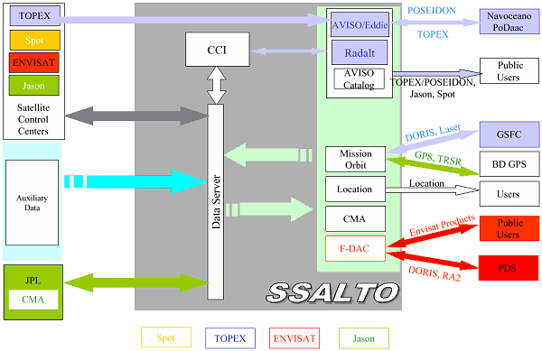
SSALTO components
- The Data Server supports transmission and reception of data with external agencies and between SSALTO components.
- The Multi-mission Altimetry Center (CMA) generates altimetry products for the RA-2 altimeter on ENVISAT-1 and POSEIDON-2 on Jason-1. NASA will operate an identical center at JPL.
- The French- Distribution and Archiving Center (F-DAC) communicates with the ENVISAT Payload Data Segment (PDS), and archives and distributes external ENVISAT products generated by French program partners.
F-DAC and the ENVISAT-1 part of the CMA together make up the F-PAC (French Processing and Archiving Center).
F-DAC relies on generic elements supplied by ESA and dedicated elements developed by CNES. The latter interface with the generic elements and with SSALTO components, and archive and generate external products for distribution.
- The Instrument Control Center (CCI) controls the DORIS and POSEIDON instruments on the Spot, TOPEX/POSEIDON, Jason-1 and ENVISAT-1 satellites. It also controls and commands the DORIS orbitography network. The CCI will reuse a large proportion of the software already running at the SSDP to control the DORIS and POSEIDON-1 instruments and the beacon network. A version of this software will also be delivered for navigation missions using DORIS.
- The Mission orbit center will generate orbit products for the Spot, TOPEX/POSEIDON, Jason-1 and ENVISAT-1 missions.
- The Location center will generate ground beacon location products derived from DORIS measurements.
- The AVISO Catalog will archive and distribute Spot, TOPEX/POSEIDON and Jason products, as well as location products for the public users.
- RADALT will generate POSEIDON-1 altimetry products.
- AVISO-EDDIE will generate merged altimetry products combining data from the French and US payloads on TOPEX/POSEIDON.
SSALTO will give CNES the resources it needs to meet the requirements of the user community for the next two decades. SSALTO has been designed to control a large number of instruments concurrently and has the capacity to scale up to support the various altimetry, orbit determination and accurate location missions scheduled in the early years of the next millennium.
News
 Archives .
- Aviso Newsletter .
- Newsletter 1 .
- Newsletter 2 .
- Newsletter 3 .
- Newsletter 4 .
- Newsletter 5 .
- Newsletter 6.
- Newsletter 7 .
- Jason-1, after T/P.
- Jason system overview and status.
- Ssalto, new ground segment.
- Review of 1999 and future AVISO activities.
- Jason-1 Calibration/Validation.
- Absolute altimeter calibration in Corsica.
- AVISO CALVAL Activities.
- Multi-variate assimilation to initialize El Niño predictions.
- Investigation at regional scales of sea level variability.
- Assimilating TOPEX/POSEIDON data to better understand Warm Pool replenishment and depletion.
- Further details of the 1997-98 El Niño.
- TOPEX/POSEIDON and TAO: Comparative simulation.
- Newsletter 8.
- Newsletter 9.
- Newsletter 10.
- Search.
- Front-page news.
- Image of the month .
- Operational news and status .