


Absolute altimeter calibration in Corsica
P. Exertier, P. Bonnefond, O. Laurain, F. Barlier (OCA/CERGA, France), Y. Ménard (CNES, France), E. Jeansou (NOVELTIS, France), A. Orsoni (IGN, France), B. Haines (NASA/JPL, USA), D. Kubitschek, G. Born (CCAR, USA)
Two absolute calibration sites were chosen in Corsica at the end of 1996. These sites - at Aspretto (Ajaccio, southern Corsica) and Cap Senetosa (southern Corsica) - were easily accessible with the ultra-mobile laser ranging station. In preparation for the Jason-1 mission, we have conducted a number of geodetic surveying campaigns to reduce the vertical error budget to no more than one centimeter. By measuring the slope of the marine geoid in the vicinity of tide gauges using GPS buoys in 1998, combined with a laser-based short-arc orbit determination technique, we were able to calculate a TOPEX calibration value from 14 cycles (June to November 1998) of +3.5 ± 15.0 mm (AVISO GDR-M, orbits supplied by CNES).
Absolute calibration of radar altimeters has been used previously for ERS-1 in Venice, for Poseidon in Lampedusa, and for TOPEX on the Harvest platform [Ménard et al., 1994]. These “conventional” experiments proved very troublesome to implement, given the remoteness of the sites and the complex combination of satellite-based, geodetic surveying and tide gauge techniques. Today, we can monitor absolute calibration on a regular and continuous basis thanks to the long-term data obtained by the Harvest experiment. This process involves using two techniques within the same reference frame to measure the mean sea surface, i.e., radar altimetry and orbit determination, and geodesy and tide gauges. Short-term and long-term uncertainties from over 200 cycles of data acquired at this site are, respectively, of the order of a few centimeters and a few millimeters per year [Haines et al., 1998].
Other calibration techniques have been developed in an attempt to eliminate the uncertainties associated with conventional methods. Such uncertainties stem from the inability to determine the possible vertical motion of tide gauges, of the order of a few millimeters per year (due to tectonic plate motions and so on). It is also true that such efforts have aimed to reduce the very high costs involved. These techniques rely essentially on GPS buoys or tide gauges [Born et al., 1994; Chambers et al., 1998].
However, all experiments thus far have attempted to decorrelate the drift of altimeters and associated devices (e.g., water vapor radiometer) from the long-term variability of the mean sea level, at a level of 1 mm/year at least. The many absolute calibration sites worldwide and the range of calibration techniques now used are of great value for monitoring satellite altimetry performance at this level of accuracy, because each site and each technique brings its own systematic errors. Further, these concepts, which aim to improve the permanent vertical positioning of tide gauge sites used for altimetry, using GPS or DORIS (e.g., [Soudarin et al., 1999]), also have a major role to play in establishing a uniform and identical vertical reference frame for oceanography missions, stable to within 1 mm per year.
With these aims and future space oceanography missions such as Jason-1 and Envisat in mind, we have set up a semi-permanent site in Corsica with the lowest possible installation and monitoring costs. We have installed the ultra-mobile French Transportable Laser Ranging Station (FTLRS) for calibration passes at this site. We have also installed permanent devices and conducted regular geodetic surveying campaigns [Bonnefond et al., 1997 ; Barlier et al., 1998]. Our work included a GPS buoy experiment to measure the slope of the geoid under the local TOPEX/POSEIDON (T/P) ground track in order to eliminate the main uncertainties in tying altimetry data to tide gauge data.
The Corsica site
Accuracy and cost constraints precluded selecting an offshore site in the Mediterranean, such as a small island or platform very close to a T/P ground track or to the tracks of other altimetry satellites. We chose a dual site in Corsica, with permanent geodetic instruments, including the semi-permanent FTLRS, operating at Aspretto (near Ajaccio) and tide gauges and geodetic reference points located at Cap Senetosa (near Propriano, 40 km south of Ajaccio).
The first site, located at a naval base, will be equipped in 1999 with a permanent GPS receiver and digital coastal tide gauge, by IGN, France’s national mapping and survey agency, and SHOM, the French Navy’s hydrography and oceanography department. We conducted a four-month campaign using the FTLRS [Barlier et al., 1998], which showed that this site is extremely well suited for acquiring quasi-zenithal laser ranging measurements for T/P and ERS, to complement those acquired by the European laser station network. We also showed that these measurements allow a potential reduction of the radial orbit error to about 1 cm, and even less locally, using a geometric, laser-based short-arc adjustment technique [Bonnefond et al., 1995 ; Bonnefond et al., 1999]. The FTLRS will be set up again at this site in May 2000 for the validation phase of the Jason-1 mission. The second site, at Cap Senetosa, is overflown by T/P on ascending pass n° 85. This site has three tide gauges equipped with pressure sensors (ANDERRAA) installed by CNES and OCA/CERGA operating since the end of 1996. A meteorology station will be installed in 1999.
Difficulties and limiting factors
The first difficulty we encountered in this absolute calibration experiment is the need to evaluate the slope of the geoid under the satellite ground track in the vicinity of the tide gauge. As our tide gauge is on a large island, altimetry measurements are subjected to stronger perturbations near the coastline than near an offshore platform, for example. First, the altimeter no longer acquires a pure ocean signal and second, the onboard water-vapor radiometer, which is vital to for correcting propagation of the radar range signal, observes a sudden change in humidity. These factors cause altimeter measurement precision to decline sharply, from 3 cm to 5-7 cm (Figure 1), which means that we have to stop acquiring measurements at about 5 to 10 km from the tide gauge. But this is precisely where the height of the geoid may vary, particularly in Corsica where the slope may reach several centimeters per kilometer. Moreover, local oceanographic effects may distort sea surface heights measured by the tide gauges and the satellite altimeter.
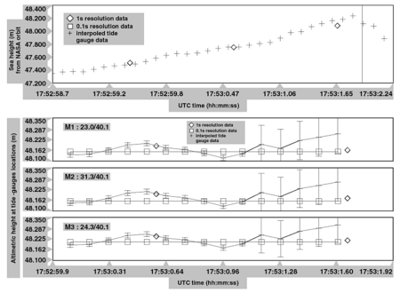
Figure 1: Experiment configuration for absolute altimeter calibration at Cap Senetosa (southern Corsica). Example from T/P cycle 211, with data from three tide gauges.
The second difficulty concerns the satellite orbit error, in particular the constant radial error directly above the site. Unless we use a geometric orbit determination technique, we have no way of discerning what proportion of this error is due to the uncertainty in the gravity field model used in the dynamic ephemeris supplied by CNES and NASA. For this reason, a laser ranging station under or very near the satellite ground track, supported by a continental network, is a very powerful tool for reducing the radial orbit error during calibration passes, provided of course that the station coordinates are sufficiently accurate (to within 5 mm in altitude) and in the same reference frame as that used for the space system [Bonnefond et al., 1999].
We conducted a four-month test campaign at the Aspretto site in 1996-97 using the FTLRS. This is a short period, given the satellite’s 10-day repeat orbit cycle, so the station could only observe relatively few calibration passes. Moreover, calibration was affected by systematic errors of several centimeters due mainly to our imperfect knowledge of the geoid for the Cap Senetosa site. This is why we conducted geodetic surveying campaigns in 1998 and 1999.
Improvements
The main objective of the 1998 geodetic campaign was to reduce the vertical error budget of the absolute calibration experiment in preparation for the Jason-1 mission. GPS tie-ins and leveling between local geodetic reference points and tide gauges at Cap Senetosa were measured and checked. The three tide gauges have since been accumulating data at a rate of one point every five minutes. Lastly, we devised an experiment using buoys equipped with GPS receivers to measure the slope of the quasi-geoid.
The principle of the GPS buoy experiment is to attempt to model the shape of the mean sea surface under the satellite ground track over a distance of about 10 km from the shore. The aim here is to obtain a mean profile from which we can interpret sea surface heights for any cycle, rather than measuring the instantaneous SSH during a single calibration pass [Born et al., 1994]. The main limiting factors, apart from infrastructure and sea state (weather conditions) when deploying the GPS buoys, concern corrections to instantaneous SSH measurements and how to interpret these measurements with respect to tide gauge data and altimetric data.
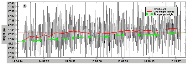
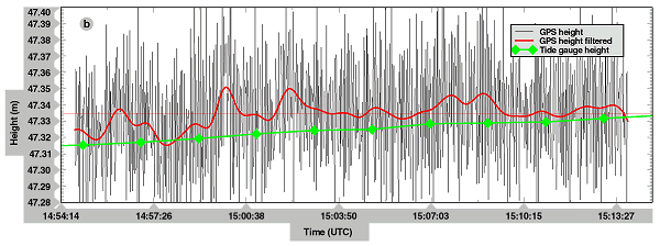
Two GPS buoys (lent by the CCAR, Boulder, USA) were allowed to float freely and acquired two sets of measurements each time with two receivers and their antennas (TurboRogue and Ashtech). We obtained differential GPS fixes from geodetic reference points on shore. We also re-ran several sessions with a different pair of receivers (TurboRogue and Sercel) for test purposes. We collected about 30 measurements at sea during the campaign, including six points directly above tide gauges and points up to 10 km from the shore under the T/P ground track.
Results
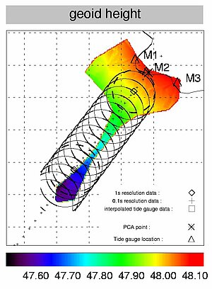
We used Prism-Pnav version 2.4 (Ashtech), 3Spack (Sercel, DSPN) and Gipsy/Oasis II (JPL) software to process GPS data. GPS sea surface height differences filtered every 60 seconds [Vondrak, 1977], depending on the receivers and software, were between 0.2 cm and 0.8 cm on average, with sigmas of 1 to 2 cm. SSH deviations between GPS and the three tide gauges were 1.8 to 0.6 cm on average, with sigmas of 1 cm (Figure 2). These data enabled us to model a mean sea surface with a slope of 6 cm/km along the T/P ground track, and up to 5 cm in 3 km across track (Figure 1).
For calibration passes 209 to 225, comparing SSH values obtained from corrected sea surface heights (AVISO CD-ROM, measurement rate of 0.1 s) and JGM-3 ELFE orbits (CNES) with SSH values derived from tide gauge data acquired simultaneously yields a mean calibration value of –20.5 ± 14.0 mm. We applied the short-arc method, based on laser ranging data from the European network, to improve the local ELFE-CNES T/P orbit above the site. Over a six-year period, the systematic radial orbit error for track 85 is +24.0 ± 5.0 mm on average. As calculations were performed in the same terrestrial reference frame, we obtain a calibration value of +3.5 ± 15.0 mm for July 1998. However, due to radial deviations observed over the last cycles between the orbits determined by CNES and NASA, this result may vary by a few millimeters. This shows that we need to achieve a further reduction in the orbit error budget for calibration of Jason-1.
In conclusion, the calibration site at Cap Senetosa can now provide us with an accurate value of T/P altimeter calibration bias. The geodetic survey campaign in 1998 removed uncertainties concerning the heights of the geoid and also provided an opportunity to test a range of GPS devices and software. Measurements of the quasi-geoid were acquired in 1999 to provide overlap points for the altimetry profile up to 20 km. In the meantime, the Aspretto site is continuing to upgrade in 1999 to improve monitoring of the island’s reference point. This will prove particularly useful when deploying the ultra-mobile laser ranging station here in 2000 for the Jason-1 validation phase. This satellite tracking technique is a vital component of this absolute calibration experiment, given the uncertainties revealed in orbit determination.
References:
- Barlier, F., P Exertier, P. Bonnefond, 1998: Regional validation in the Mediterranean, Aviso NewsLetter 6, pp. 12-13.
- Bonnefond, P., P. Exertier, P. Schaeffer, S. Bruinsma and F. Barlier, 1995: Satellite altimetry from a short-arc orbit technique: application to the Mediterranean, J. Geophys. Res., 100 (C12), 25365-25382.
- Bonnefond, P., P. Exertier, Y. Ménard, E. Jeansou, G. Manzella, S. Sparnocchia, F. Barlier, 1997: Calibration of radar altimeters and validation of orbit determination in the Corsica-Capraia area, Proceedings of the 3rd ERS Symposium, Mar 17-21, Florence, Italy.
- Bonnefond, P., P. Exertier, F. Barlier, 1999: Geographically correlated orbit errors determined from a laser-based short-arc technique, J. Geophys. Res., 104 (C7), (in press).
- Born, G.H., M.E. Parke, P. Axelrad, K.L. Gold, J. Johnson, K.W. Key, D.G. Kubitschek, 1994: Calibration of the TOPEX altimeter using a GPS buoy, J. Geophys. Res., 99 (C12), 24517-24526.
- Chambers, D.P., J.C. Ries, C.K. Shum, B.D. Tapley, 1998: On the use of tide gauges to determine altimeter drift, , J. Geophys. Res., 103 (C6), 12885-12890
- Haines, B. et al., 1998: SWT TOPEX/POSEIDON – Jason-1, Keystone, CO, Oct. 1998.
- Ménard, Y., E. Jeansou, P. Vincent, 1994: Calibration of the TOPEX/POSEIDON altimeters at Lampedusa: Additional results at Harvest, J. Geophys. Res., 99 (C12), 24487-24504.
- Soudarin, L., J.F. Crétaux, A. Cazenave, 1999: Vertical crustal motions from the DORIS space-geodesy system, Geophys. Res. Lett. (in press).
- Vondrak, J., 1977: Problem of smoothing observational data, Bull. Astron. Inst. Czech, 28, pp. 84-89.
News
 Archives .
- Aviso Newsletter .
- Newsletter 1 .
- Newsletter 2 .
- Newsletter 3 .
- Newsletter 4 .
- Newsletter 5 .
- Newsletter 6.
- Newsletter 7 .
- Jason-1, after T/P.
- Jason system overview and status.
- Ssalto, new ground segment.
- Review of 1999 and future AVISO activities.
- Jason-1 Calibration/Validation.
- Absolute altimeter calibration in Corsica.
- AVISO CALVAL Activities.
- Multi-variate assimilation to initialize El Niño predictions.
- Investigation at regional scales of sea level variability.
- Assimilating TOPEX/POSEIDON data to better understand Warm Pool replenishment and depletion.
- Further details of the 1997-98 El Niño.
- TOPEX/POSEIDON and TAO: Comparative simulation.
- Newsletter 8.
- Newsletter 9.
- Newsletter 10.
- Search.
- Front-page news.
- Image of the month .
- Operational news and status .