


Ssalto/Duacs multimission altimeter products
Duacs is the Ssalto multimission altimeter data processing system. It serves in near-real time the main operational oceanography and climate forecasting centers in Europe and worldwide.
Panel of SSALTO/Duacs products distributed by AVISO+ and CMEMS
Panel of products distributed by AVISO+ and CMEMS in the frame of the SSALTO/Duacs altimetry processing: along-track and gridded products (variables Sea Level Anomaly, Absolute Dynamic Topography, and associated currents), eddy trajectory atlas. The high resolution video can be downloaded on the AVISO+ gallery. Credits CNES/CLS/European Copernicus Marine Service.
SSALTO/DUACS experimental products: new release (June 2018)
For 20 years, the DUACS system has been producing, as part of the CNES/SALP project, and the Copernicus Marine Environment and Monitoring Service (CMEMS), high quality multimission altimetry Sea Level products for oceanographic applications, climate forecasting centers, geophysics and biology communities... While the operational production of the Sea Level along track and maps is now generated as part as CMEMS, the development of a new experimental SSALTO/DUACS products started mid 2016 at CNES aiming at improving the resolution of the current products and designing new products. Using the global Synthetic Aperture Radar mode (SAR Mode) coverage of Sentinel3A/B and optimizing the LRM (Low Resolution Mode) altimeter processing (retracking, editing, ...) will notably allow us to fully exploit the fine-scale content of the altimetric missions. Thanks to this increase of real time altimetry observations we will also be able to improve Level-4 products by combining these new Level-3 products and new mapping methodology, such as dynamic interpolation. Finally, these improvements will benefit to downstream products: geostrophic currents, Lagrangian products, eddy atlas…
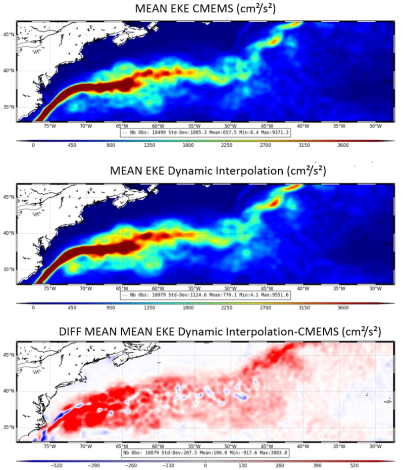
An illustration of the improvement of this new product is given in the opposite figure: comparison of mean Eddy Kinetic Energy (EKE) over the period [12/04/2014-31/12/2015] for DUACS products: operational (top), new experimental computed with Dynamic Interpolation (middle) and the difference between the two (bottom) where red color indicates areas of higher energy. Credits CNES/CLS. Click to enlarge. Animation of EKE available on the gallery. Explanation about EKE can be found here
Oil spill in the China Sea resulting from the Sanchi tanker disaster (January 2018) superimposed with the FSLE products (unit days-1) for the same period.
ACCESS TO PRODUCT
The new release includes the products available on the product page
Users should keep in mind that these products are experimental products. Notably, they are not produced on an operational basis.
On the AVISO+ website, the products are identified as follows:
- "Ssalto/Duacs Experimental products: along-track and gridded Sea Level Heights and velocities” for the level 3 along-track 5 Hz products and the level 4 merged products computed with Dynamic Interpolation and combing altimetry/drifters and altimetry/SST
- “Lyapunov Exponents and Orientations products” for the level-4 gridded FSLE (for delayed time as well as for routine production called near-real-time)
If you are not registered, please, fill the form on the registration page and select the products detailed above.
If you are already registered on AVISO+, you can access to the products on ftp in your own AVISO+ dedicated space.
- If you don't remember your password, please reset it here
- If this product doesn't appear in "your current subscriptions", you don't need to fill the form entirely: please select it in the "other products you may want to access" and sign the licence. We will register you as soon as possible (depending on the conditions of use).
FEEDBACKS:
The Service Desk (aviso(at)altimetry.fr) is highly interested in user feedbacks: questions, comments, proposals, requests are much welcome to help us improving the quality of the products disseminated to users.
SSALTO/DUACS Operational products
Ssalto/Duacs system processes data from all altimeter missions (Jason-3, Sentinel-3A, Saral, Cryosat-2, Jason-1&2, T/P, Envisat, GFO, ERS-1 & 2 and even Geosat) to provide a consistent and homogeneous catalogue of products for varied applications, both for near real time applications and offline studies. They are disseminated by the Marince Copernicus Services (CMEMS)
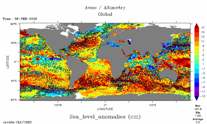
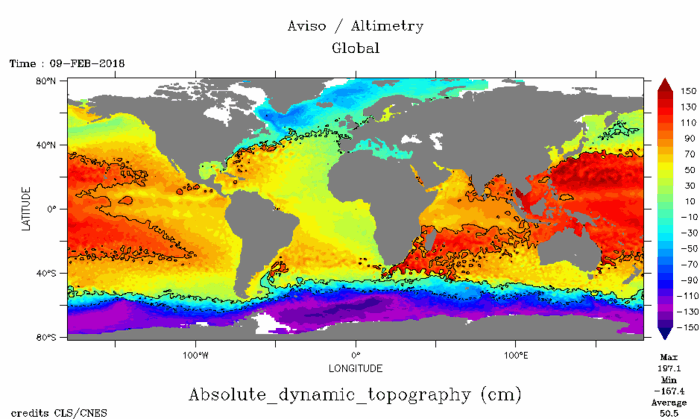
Duacs maps (Sea Level Anomalies, top, Absolute Dynamic Topography, bottom). Browse through more of them through our "Sea views" interface. Credits CLS/Cnes.
Données
- Guide des produits.
 Produits .
- Accès aux données .
- Information sur les produits .
- Manuels d'utilisation des produits Aviso+.
- Format des données.
- Citation et licence d'utilisation des produits Aviso+.
- Information about mono and multi-mission processing .
- Processing steps and data levels.
- Ssalto .
- Ssalto/Duacs multimission altimeter products.
- Specific processing .
- Updates and reprocessing .
- CALVAL .