


One thousand drifters and one future satellite in the Gulf of Mexico
Image of the Month - April 2016
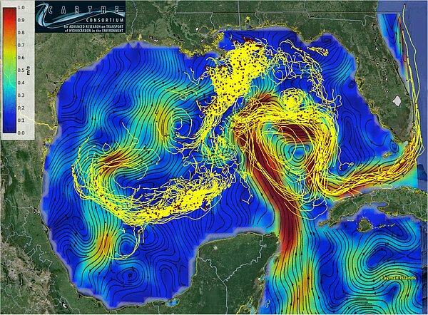
The Gulf of Mexico shows a number of interesting oceanic features. The Loop Current for example enters the Gulf by the strait between the Yucatan Peninsula and Cuba, and makes a loop that goes more or less deep. Sometimes, this loop breaks, and forms a lone eddy (or ring). This can have real impact, especially on hurricane intensification, and on navigation. Moreover, the Gulf of Mexico is an oil exploration area, that oceanic perturbations like these eddies can seriously disorganize, or even make hazardous.
During January 15 - February 15, 2016, a large coordinated expedition in the Gulf of Mexico, denoted LASER - LAgrangian Submesoscale ExpeRiment was conducted. During this expedition, more than 1000 biodegradable surface drifters have been released and they are being tracked every five minutes, and should last well into April 2016. The expedition was conducted from two ships and at times three aircrafts. The aircrafts measured fine-scale sea-surface temperature (SST) that was used to guide the ships to target drifter deployments in real time. Altimetry and other satellite data were used for experimental planning every day. AirSWOT, the airborne instrument prefigurating SWOT altimeter flew over the drifter array.
The comparison of drifter motion and both satellite and airborne measurements should be quite instructive for scientific purposes. AirSWOT results, compared with drifter paths should help preparing for SWOT high-resolution data over ocean.
[The Consortium of Advanced Research for Hydrocarbons in the Environment (http://carthe.org/) is a multi-institutional research group, supported by the Gulf of Mexico Research Initiative (http://gulfresearchinitiative.org/). CARTHE is investigating transport processes in the upper ocean in the aftermath of the 2010 Macondo blowout. It organized the LASER expedition.]
See also:
- Applications: oceanography / multi-sensors
- Applications: Oceanography / submesoscale circulation
- Missions: Swot
Other websites on this subject:
News
 Archives .
- Aviso Newsletter .
- Search.
- Front-page news.
- Image of the month .
- 2025 .
- 2024 .
- 2023 .
- 2022 .
- 2021 .
- 2020 .
- 2019 .
- 2018 .
- 2017 .
- 2016 .
- Dec. 2016: Testing Algorithms.
- Oct. 2016: A typhoon seen by satellites.
- Sep. 2016: The Silent World disturbed by icebergs' noise.
- Aug. 2016: It's raining under Jason-3.
- Jul. 2016: Elephant seals and macaroni penguins follow threads.
- June 2016: Turning around in the Lofoten eddy.
- May 2016: Readying for SWOT data to be used in hydrology applications.
- Apr. 2016: One thousand drifters and one (future) satellite in the Gulf of Mexico.
- Mar. 2016: Storm in the Bay of Biscay.
- Feb. 2016: Thule Doris station's rising at different velocities.
- Jan. 2016: The 2015 El Niño: An extraordinary Modoki event?.
- 2015 .
- 2014 .
- 2013 .
- 2012 .
- 2011 .
- 2010 .
- 2009 .
- 2008 .
- 2007 .
- 2006 .
- 2005 .
- 2004 .
- 2003 .
- 2002 .
- 2001 .
- 2000 .
- 1999 .
- 1998 .
- Operational news and status .