Mega-icebergs seen by Swot
Image of the Month - December 2023
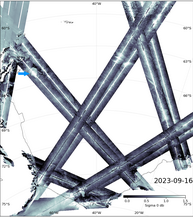
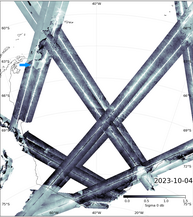
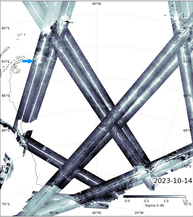
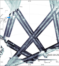
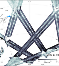
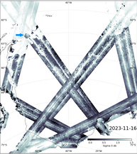
KaRIn reflected power (sigma0) on Sept. 16, Oct. 4, 14 and 25, Nov. 4 & 16 over the Weddell Sea and adjoining Southern Ocean. The A-23a iceberg is indicated on all six images by the blue arrow. Its position on Sept. 16 is the one it had had for the past decades before it began moving again, out of the Weddell Sea. The reflected power data represent the iceberg as a black (i.e. not reflecting the radar beam back to the altimeter antennas) surface. (Credit Cnes/CLS/JPL)
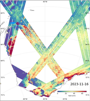
Iceberg A-23a, which broke off from the Filchner-Ronne Ice Shelf in 1986, started moving again in 2020 and recently broke away from the sea ice around Antarctica. The massive iceberg (3900 km², slightly larger than the island of South Georgia, where it might go next) is visible in the sea surface height data of the Swot mission (Nasa/Cnes) and has been for some time. In fact, we have already published a Swot image with this iceberg in (look for it in Swot scans the Southern Ocean ), without commenting on the fact. It is not the largest iceberg ever observed, but it is definitely the largest currently in existence.
Since they are already floating on the ocean, such icebergs that break away from ice shelves do not directly cause sea level rise. However, they can affect the flow of the glacier from which they came. Without such a "plug" at its end, the glacier could flow faster and thus contribute to sea level rise.
Because of its 200 to 300 m deep "keel", deep currents will be the driving force behind its movements. The A-23a iceberg will either hit the continental shelf around South Georgia and, like its predecessor A-76a (part of which is still around the island), remain there at least for a while, be caught by eddies, or follow the Antarctic Circumpolar Current around the continent, slowly breaking up into smaller and smaller pieces before melting completely in the course of several years. In the meantime, it will be a hazard to navigation, but it will also seed the deep ocean with mineral deposits and have a dampening effect on waves (see Wave models with ice ).
Swot won't be an iceberg warning system for navigation in itself, since its repetitive cycle is 21 days, but it will make it possible to monitor them even during the polar night and under heavy clouds. It can thus contribute to a better understanding of their trajectories and to their detection in conjunction with prediction models for warning systems.
Iceberg A-76a piece breaking into further smaller pieces, seen in Swot KaRin sigma0 data (reflected power of the radar beam) near South Georgia. Data from the 1-day orbit phase (Credit Cnes/CLS/JPL)
See also:
- Image of the Month, October 2023: Swot scans the Southern Ocean
- Image of the Month, January 2017: Wave models with ice
- Image of the Month, September 2013: Icebergs on the move
- Image of the Month, November 2008: Counting icebergs
- Missions: Swot
- Applications: Ice sheets and sea ice
- an animation available on Aviso's YouTube channel, showing a similar iceberg's path overlaid on SST
Other website on this subject:
- ESA's news on A-23a (using SAR imagery)
- Nasa's Earth Observatory News: Antarctic Iceberg Sails Away (visible imagery and trajectory of A-23a since 2011)


