


Actualités
[Jason-1] Temporary reintegration of Jason-1 data flows in Duacs (copie 1)
In consequence of the Jason-1 manoeuvers, recent data from Jason-1 were not processed in Duacs in NRT. Thanks to a combination of corrections, data showed that the degradation was minor. Thus all data flows (IGDR or OGDR) from Jason-1 since the initial fuel depletion maneuver are re-injected in Duacs (along-track SLA products, multi-satellite map).
Since 2010/07/19, Jason-1 has been affected by a series of hydrazine depletion manoeuvers (burning extra fuel to reduce the risk associated to collisions of this aging satellite). The practical consequence of these manoeuvers is that the satellite oscillates around its repetitive ground track in band of 7 km at high latitudes, whereas the repetitive track is usually controlled within less than 1 km. As far as altimetry processing are concerned, the risk associated to this configuration is a degradation of the SLA from a subpar cross-track geoid gradient correction (or CTGG, see Dorandeu et al, 2003) or inadequate mean profile (time reference used for the computation of Sea Level Anomalies).
Consequently, recent data from Jason-1 were not processed in Duacs in Near Real Time as a conservative measure.
After a one-week, the analysis of OSDR and IGDR data showed that the degradation was minor thanks to the combination of a CTGG correction based on the recent mean sea surface (<link internal-link>MSS_CNES_CLS10) and a precise time reference from the repetitive track (mean profile). The oscillation is also much less of a problem than the periodic pointing issue associated to the loss of star traking and pointing capability on Jason-1 (degraded coverage, no recovery action is possible).
Thus all data flows from Jason-1 since the initial fuel depletion maneuver (about one week worth of IGDR or OGDR data) are re-injected in Duacs today and in the coming days and should be available as along-track SLA products, as well as used in the multi-satellite map.
However, Jason-1's cross-track distance is not stable (see Figure below) so the automatic processing of Jason-1 data flows will not be re-activated. The quality control analyses to be performed next week will decide if newer Jason-1 data can be released. This approach will be used until the end of the series of maneuvers (2010/08/04).
<link fileadmin images news mod_actus j1_cross_track_distance_during_maneuvers.png download>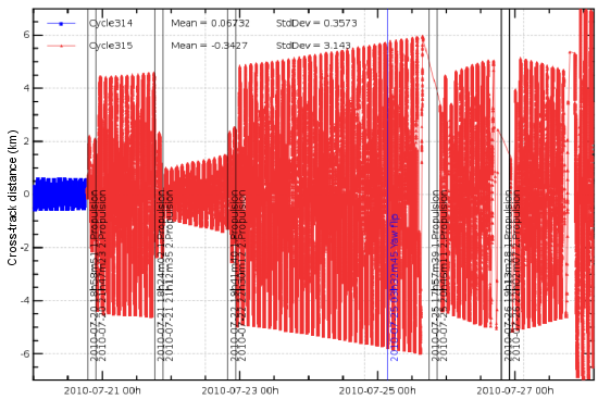 |
Monitoring of Jason-1 cross-track distance as a fonction of date for cycle 315 (from OSDR). |
In conclusion, it's important to highlight that despite the many satellite orbit changes (about 4 sequences per week), quite a lot of effort is deployed to keep providing Jason-1 data with a near real time quality as good as possible, albeit with a timeliness limited by the extended quality control performed by Jason-1's Cal/Val team. A lot of credit goes to the satellite and ground segment and operators from the Agencies as they provide Level 2 O/IGDR quality upstream data without which nothing would be possible in Duacs & SL-TAC.
Further information:
- 2010/07/28: <link http: www.aviso.oceanobs.com en news-storage news-detail _top external-link-new-window>[Jason-1] : Low tracking performance on the star trackers.
- 2010/07/20: <link http: www.aviso.oceanobs.com en news-storage news-detail _top external-link-new-window>[Jason-1]: End of life plan