


Jason-2 reprocessing
Since the launch of the Jason-2 satellite on June 20, 2008, the GDR (Geophysical Data Record) data were distributed in version T. For the first time, this year, a whole mission reprocessing occurred for Jason-2 altimetric data set. All cycles from 1 to 145 (covering the period from July 12, 2008 to June 18, 2012) were reprocessed into a homogeneous standard (GDR-D version) and added to the current production time series. Note that the operational version of Jason-2 GDR switched to standard D from cycle 146 onwards (for IGDR, from cycle 150 onwards; see operational news: switch to GDR-D version).
The global report presented here deals with the complete reprocessed period (cycles 1 to 145) of the Jason-2 mission, thanks to comparison with previous Jason-2 GDR-T standard, as well as comparison with Jason-1 and Envisat data. It also contains the impact of the reprocessing on the mean sea level trend. (see complete report of Jason-2 reprocessing file).
Preliminary comparison:
A first overview of the impact of the GDR-D version of Jason-2 altimeter system over ocean was performed over the formation flight phase (cycles 001 to 020 from July 12, 2008 to January 26, 2009). [ref: S. Philipps, H. Roinard and M. Ablain, 2012: "Jason-2 reprocessing impact on ocean data (cycles 001 to 020). Comparison of Jason-2 Gdr-D with Gdr-T, as well as with Jason-1 Gdr-C." JA2_GDR_D_validation_report_cycles1to20_V1_1.pdf]
In terms of available and valid data:
Data availability of GDR-D products is equivalent to the data availability of GDR-T products. For some cycles, data which were missing in GDR-T version are present in GDR-D version. Percentage of invalidated data is similar between GDR-T and GDR-D. Nevertheless, GDR-D products have more edited data likely due to the use of MQE criterium during the 20Hz to 1Hz compression.
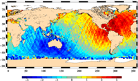
In terms of performance at cross-overs:
GDR-D data improve the coherence of ascending / descending SSH differences as geographically correlated patterns are reduced.
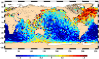
Mean in cm of ascending/descending differences of SSH at crossovers, using GDR-T (left) or GDR-D (right) standards. Credits CNES/CLS.
The standard deviation of SSH differences is systematically lower for GDR-D than for GDR-T data. The global SSH variance reduction is about 1.7cm², with occasionnally reductions up to 3cm² for a cycle. This variance reduction and a mean closer to zero with reduced correlated patterns are signs of an improved coherence of ascending/descending passes, which is mainly due to the new orbit solution, the use of GOT4.8 tide instead of GOT00 tide,and the modified datation used for GDR-D data.
In terms of Global Mean Sea Level trend:
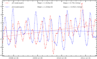
For GDR-D, there is a very good improvement as the odd/even pass MSL trend differences is reduced to less than 0.1mm/yr (instead of 0.74mm/yr using GDR-T data set). Note that a near-120-days signal still remains.
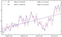
The global MSL trend using Jason-2 GDR-D increases by 0.2mm/yr compared to GDR-T Global MSL when using radiometer wet troposphere correction. The main contributor to the trend modification between GDR-D and GDR-T data is the radiometer wet troposphere correction (+0.35mm/yr when using the GDR-D radiometer wet troposphere correction) and to a lesser extent the POE-D orbit standard (-0.1mm/yr when using the POE-D orbit standard).
In terms of Regional Mean Sea Level:
Hemispheric east / west differences up to +/-3mm/yr are observed, mainly related to the change of orbit solution.
Details about main evolutions:
- The main improvement in GDR-D version is its new orbit. This solution very much improves the coherence of ascending/descending SSH differences. It also improves the coherence between Jason-2 and Envisat as there are no longer east/west biases
- The pseudo time-tag bias mean (-0.29ms for Jason-2 GDR-T) has been corrected and is now close to zero. Consequently, the small north/south hemispheric differences on Jason-2 SSH crossovers differences are reduced.
- Radiometer parameters have been enhanced in coastal regions, and an anomaly in 34GHz channel has been corrected. New AMR calibration coefficients are also used.
- The expected modifications with the update of the altimeter characterization file, corrected pole tide solution, altimeter wind speed, global tide model are observed.
- GDR-D sea state bias is calculated with a different approach for low sea states. Main differences are observed in these areas (as the editing method has changed). Note that an updated version of SSB model (based on GDR-D data) was presented at OSTST2012.
Further information:
- Complete report of Jason-2 reprocessing
- Systematic Validation activities
- Mean Sea Level Rise