


OSTST 2013 Posters
Here are some posters made for the Ocean Surface Topography Science Team 2013 meeting
Instrument Processing
| C. Buchhaupt et al. | Retracking and validation of pulse-limited and SAR altimetry in costal zone | pdf (2.46 MB) |
| P. S. Callahan et al. | Progress in retracking TOPEX data for the climate data record | pdf (422 MB) |
| S. Dinardo et al. | Coastal and Inland water SAR altimetry at 80 Hz | pdf (1.87 MB) |
| T. Moreau et al. | Investigation of swell impact on SAR-mode measurements | pdf (672 KB) |
| M. Passaro et al. | ALES, the multi-mission adaptive leading edge sub-waveform retracker, design and validation | pdf (2.75 MB) |
| S. Thao et al. | New characterization of radiometer wet troposphere correction errors tanks to the ERA-interim reanalysis and AMSR products | pdf (984 KB) |
| G. Valladeau et al. | SARAL/AltiKa altimeter data over open ocean, coastal zones and inland waters: the PEACHI project | pdf (222 KM) |
Near Real Time Products and Applications and Multi-Mission, Multi-Sensor Observations
| L. Aouf et al. | The assimilation of CFOSAT synthetic wave data in the wave model MFWAM | pdf (1.95 MB) |
| P. Gorringe et al. | GMES-PURE: Shaping the marine GMES/COPERNICUS user requirements | pdf (604 KB) |
| L. Carrère et al. | Improving the Dynamic Atmospheric Correction for operational altimetry (NRT and RT) | pdf (287 KB) |
| P. Cipollini et al. | Comparison and validation of mult-mission coastal altimetry around Venice | pdf (1.75 MB) |
| S. D. Desai et al. | High-accuracy sea surface height data in Near-Real-Time from the SARAL and Jason-2 missions | pdf (7.17 MB) |
| Y. Faugère et al. | SSALTO/DUCAS: The Jason1 / Altika unexoected handover | pdf (2.66 MB) |
| P. Harwood et al. | The contribution of altimetry to storm surge modelling in the eSurge project | pdf (3.84 MB) |
| M. Saraceno et al. | Southwestern Atlantic currents from in-situ and satellite altimetry data | pdf (538 KB) |
| C. Troupin et al. | Interpolation of SLA using Diva: Near-real teme application during a multi-sensor experiment in the Ibiza Channel | pdf (5.35 MB) |
Outreach, Education and Altimetric Data Services
| F. Briol et al. | Aviso Online Data Extraction Service: a new way of disseminating altimetry data | pdf (1.7 MB) |
| S. Fleury et al. | CTOH: L1 to L4 altimetry products | pdf (6.72 MB) |
| F. Mertz et al. | Aviso products & services: what's new ? (2013) - future developments (2014) | pdf (2.45 MB) |
| V. Rosmorduc et al. | Argonautica: behind the scenes (que se passe-t-il derrière l'écran ?) | pdf (2.2 MB) |
| V. Rosmorduc et al. | Basic Radar Altimetry Toolbox: Tools for Saral altimetry data users | pdf (4.87 MB) |
| V. Rosmorduc et al. | LearnEO ! Learn Earth Observation with ESA | pdf (6.35 MB) |
| C. Schwatke et al. | OpenADB: An Open Altimeter Database providing high-‐quality altimeter data and products | pdf (2MB) |
| M. Srinivasan et al. | Enhancing science and promoting proctical applications of high-resolution altimetry measurements | pdf (5.67 MB) |
Precision Orbit Determination
| K. Akiyama et al. | Development Status of GPS-Based precise orbit detemination system for Japanese Ocean Surface Topography Mission (COMPIRA) | pdf (972 KB) |
| N. P. Zelensky et al. | Orbit error due to time variable gravity and impact on mean sea level trend estimates and tide gauge calibration | pdf (538 KB) |
Quantifying Errors and Uncertainties in Altimetry Data
| M. Ablain et al. | Why altimetry errors at climate scales are larger in the first decade (1993-2002) ? | pdf (731 KB) |
| L. Carrere et al. | Comparisons to in situ data and estimation of errors in the Dynamic Atmospheric correction | pdf (255 KB) |
| C. Delebecque et al. | Using CTOH tidal constants for coastal studies | pdf (6.50 MB) |
| C. Dufau et al. | Reducing altimetry small-scales errors to access (sub) mesoscale dynamic | pdf (652 KB) |
| E. S. Garcia et al. | Retracking Jason-1 altimeter waveforms for marine gravity recovery | pdf (MB) |
| D. Masters et al. | Bumps and Wiggles: making sense of sea level climate record variability | pdf (380 KB) |
| M. G. Scharffenberg et al. | Asymmetries between along- and across- track velocity wevenumber spectra from tandem-mission altimetry | pdf (2.05 MB) |
Regional and Global CAL/VAL for Assembling a Climate Data Record
| J.J. Benjamin et al. | The 2013 Ibiza calibration campaign of Jason2 and Saral altimeters | pdf (197 KB) |
| B. Beckley et al. | Impact of revised time variable realizations on geocentric sea level estimates derived from the TOPEX/Poseidon/Jason Climate Data Record | pdf (8 MB) |
| S. D. Desai et al. | Global calibration and validation of the Jason-2 and SARAL geophysical data records | pdf (3.4 MB) |
| L. Fenoglio et al. | Validation of altimeter data in the German Bight | pdf (2.3 MB) |
| V. Koch et al. | Global Quality Assessment of updated Geosat Dataset | pdf (396 KB) |
| P. Matton et al. | Significant Wave Height evolution towards a climate dedicated multimission product | pdf (2.8 MB) |
| S. P. Mertikas et al. | preparatory steps for a permanent infrastructure in West Crete to calibrate Sentinel-3, Cryosat-2 and Jason missions with a prototype microwave transponder | pdf (375 KB) |
| A. Michel et al. | Land Ice Cal/Val: importance of ice sheets monitoring | pdf (2.45 MB) |
| M. C. Naeije et al. | Altimetry CAL/VAL: a closer look at Cryosat-2 | pdf (2.5 MB) |
| A. Ollivier et al. | Cryosat LRM performances over ocean | pdf (4 MB) |
| A. Ollivier et al | Envisat ocean altimetry performance assessment - End of life and overview of a successful mission | pdf (1.76 MB) |
| S. Philipps et al. | Jason-1 and Jason-2 altimeter validation activities over ocean i the framework of the SALP project | pdf (809 KB) |
| M.-I. Pujol et al. | SSLATO/DUACS : the reprocessing of the 20 years of data is on going | pdf (334 KB) |
| H. Roinard et al. | Comparison of MLE3 and MLE4 retracking performances using Jason-2 GDR dataset: impact on sea Surface Height estimation | pdf (2.95 MB) |
The Geoid, Mean Sea Surfaces and Mean Dynamic Topography
| liste W. Bosch et al. | Instantaneous profiles of Dynamic Ocean Topography (iDOT-profiles) - updated with GOCO03S | pdf (2.1 MB) |
| P. Knudsen et al. | A global mean ocean circulation estimation using GOCE - DTU12MDT | pdf (307 KB) |
Others
| F. Baup et al. | Combined use of high resolution satellite images and altimetry to estimate volume of small lakes | pdf (1.21 MB) |
| S. Birkett et al. | Application of multiple RA data sets to serve inland water projects: (A) Water accounting across the Balonne floodplain, Australia | pdf (1.56 MB) |
| O. Isoguchi et al. | Generation of COMPIRA simulated data | pdf (6.7 MB) |
Science Results from Satellite Altimetry
| O. Andersen et al. | Cryosat-2 SAR altimetry for recovering Sea Surface height around and in Denmark - First results from the LOTUS Project | pdf (2 MB) |
| S. Biri et al. | SSH and velocity frequency and wavenumber spectra in the Atlantic Ocean, estimated from altimetry and a hierarchy of numerical simulations | pdf (1.7 MB) |
| P.A. Bouttier et al. | The control fo non-linear mesoscale ocean circulation through altimetric data assimilation revisited using a variational approach | pdf (5.5 MB) |
| G. Candille et al. | Towards an ensemble stragtegy for altimetric data assimilation into eddy-resolving ocean circulation models | pdf (3 MB) |
| L. Carrère et al. | FES 2012, a new tidal model - validation results and perspectives of improvements | pdf (435 KB) |
| R. Castelao et al. | Mesoscale eddies in the South Atlantic Bight | pdf (239 KB) |
| B. D. Dushaw et al. | Tidal currents of global tidal models tested using estimates from ocean acoustic tomography | pdf (606 KB) |
| B. D. Dushaw et al. | Toward global predictions of the mode-1 internal tide | pdf (7 MB) |
| T. Farrar et al. | Aspects of wave radiation in the world oceans | pdf (5.11 MB) |
| L. Gaultier et al. | On the joint use of high resolution tracer images and altimetric data for the control of ocean circulations | pdf (5.9 MB) |
| S. Gille et al. | Evaluating wavenumber spectra in Drake passage with ADCP and altimeter measurements | pdf (1.10 MB) |
| L. Gourdeau et al. | Meso-scale activity in the Solomon Sea | pdf (721 KB) |
| K. Ichikawa et al. | Ageostrophic components in the coastal sea surface height obtained from the GPS on a ferryboat | pdf (1.95 MB) |
| T. Kuragano et al. | Regional Ocean Mass Contribution to Sea Surface Height variations with seasonal timescale | pdf (2.20 MB) |
| F. W. Landerer et al. | The anatomy of the large sea level fluctuations in the Mediterranean sea in 2010 & 2011 | pdf (3.2 MB) |
| F. W. Landerer et al. | Evaluation of CMIP5 dynamic sea surface height multi-model simulations against AVISO satellite observations | pdf (5.7 MB) |
| G. Larnicol et al. | The ESA climate change initiative sea level project: validation phase | pdf (3.57 MB) |
| C. Lazaro et al. | Synergistic use of remote sensing data for the study of the Azores ans St. Helena current systems | pdf (5.17 MB) |
| W. Llovel et al. | Quantifying the respective contribution of wind stress and diabatic forcing to decadal temperature changes and regional sea level trends over 1993-2010 based on ECCO solutions | pdf (3.64 MB) |
| N. Maximenko et al. | Lagrangian connectivity of near-surface ocean studied with in situ and satellite observations | pdf (7.5 MB) |
| O. Melnichenko et al. | Multiple, migrating quasi-zonal jets in the eastern North Pacific | pdf (1.9 MB) |
| A. M. Maharaj et al. | How sensitive is generalised linear rossby wave theory to uncertainties in the determination of the background mean flow ? | pdf (302 KB) |
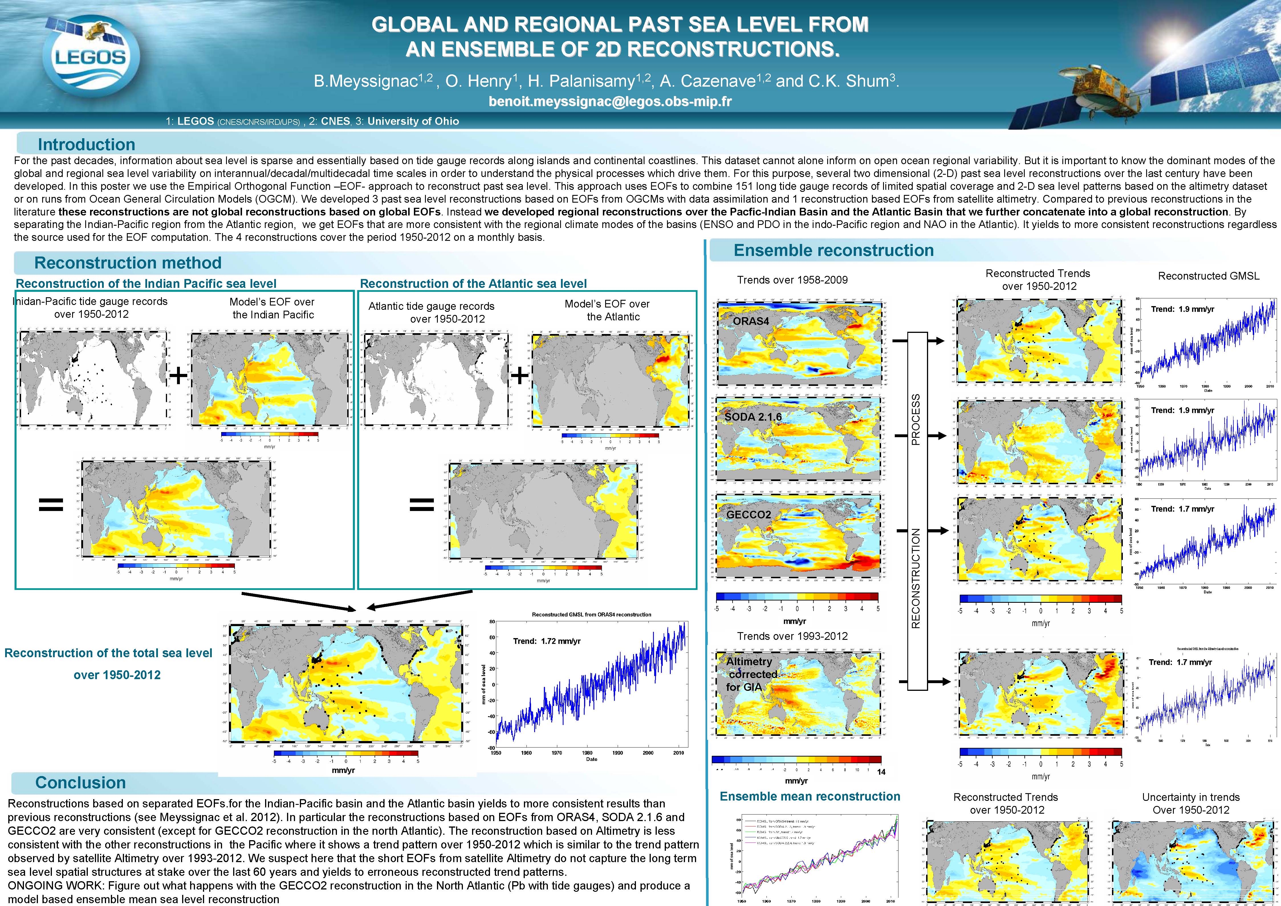
| B. Meyssignac et al. | Global and regional past sea level from an ensemble of 2D reconstruction | pdf (1.5 MB) |
| F. Nencioli et al. | SeaGoLSWOT: an oceanographic campaign in support of the AirSWOT mission in the Northwestern Mediterranean | pdf (13.3 MB) |
| F. Nino et al. | Coastal altimetry with the Ka band | pdf (1.8 MB) |
| A. Pascual et al. | Multi-sensor observations towards coastal and mesoscale characterization: SARAL/AltiKa, HF radar, glider and drifters | pdf (11 MB) |
| C. Pegliasco et al. | Vertical structure of mesoscale eddies in the four Eastern boundary upwelling systems | pdf (2.34 MB) |
| P. Prandi et al. | Exploring the behaviour of a ka-band altiemter over the Arctic Ocean | pdf (1.13 MB) |
| M. Rogé et al. | Altimetric Lagrangian advection to reconstruct fine scale tracer fields in the pacific ocean | pdf (1.22 MB) |
| M. G. Scharffenberg et al. | A probabilistic description of the mesoscale eddy field of the ocean | pdf (13.27 MB) |
| G. Sérazin et al. | Low-frequency intrinsic variability of sea surface height in the global turbulent ocean: spatio-temporal scales | pdf (4.73 MB) |
| M. Strassburg et al. | A comparative study of sea level reconstruction techniques using the 20-year satellite record | pdf (622 KM) |
| P. R. Thompson et al. | Wind-driven coastal sea level variability in the Northeast Pacific | pdf (465 KB) |
| F. Vivier et al. | Variability of the ACC transport across the kerguelen plateau monitored from 20 years of altimeter data | pdf (493 KB) |
| D. Volkov et al. | Non-seasonal fluctuations of the Arctic Ocean mass observed by GRACE | pdf (6.95 MB) |
| E. D. Zaron et al. | Can Geoditic-Mission altimetry be used to improve maps of the internal tide ? | pdf (905 KB) |
| Z. Zhao et al. | Global internal tides from multi-satellite altimetry | pdf (4 MB) |
Coin utilisateur
 Informations utiles .
- Equipes scientifiques .
- Swot Science Team .
- SARAL/AltiKa Science Team .
- OSTST - SWT Science Team .
- OSTST PIs Abstracts .
- OSTST 2023 (Puerto Rico).
- OSTST 2022 (Venice).
- OSTST 2022 March (Virtual Meeting).
- OSTST 2020 (Virtual meeting).
- OSTST 2019 (Chicago).
- OSTST 2018 (Ponta Delgada).
- OSTST 2017 (Miami).
- OSTST 2016 (La Rochelle).
- OSTST 2015 (Reston).
- OSTST 2014 (Lake Constance).
- OSTST 2013 (Boulder) .
- OSTST 2013 Posters.
- OSTST 2013 Presentations.
- OSTST 2013 Final Report.
- OSTST 2012 (Venice) .
- OSTST 2011 (San Diego) .
- OSTST 2010 (Lisbon) .
- OSTST 2009 (Seattle) .
- OSTST 2008 (Nice) .
- OSTST 2007 (Hobart).
- OSTST 2006 (Venice).
- OSTST 2004 (St. Petersburg).
- SWT 2003 (Arles).
- SWT 2002 (New Orleans).
- SWT 2002 (Biarritz).
- SWT 2001 (Solvang).
- SWT 2000 (Miami Beach).
- SWT 1999 (Saint-Raphaël).
- SWT 1998 (Keystone).
- Atelier Altimétrie et Glaciologie.


