


OSTST 2009 meeting oral presentations
Here are the oral presentations made for the Ocean Surface Topography Science Team 2009 meeting.
Monday 22 June
Program status
| E. Lindstrom | Nasa program | |
| E. Thouvenot | Cnes program status | |
| F. Parisot | Eumetsat altimetry programs | |
| L. Miller, J. Lillibridge | Noaa program | |
| J. Benveniste | ESA Earth observation program and mission status |
Keynote talks I
| J. Willis al. | Early results from the Jason-1/Jason-2 tandem mission | pdf (9 MB) |
Jason-1/ project
| G. Zaouche | OSTM/Jason-2 mission overview | pdf (2.8 MB) |
| G. Shirtliffe | Jason-1 project status | pdf (5 MB) |
Keynote talks II
| J. Lambin | Status of other altimetry missions | pdf (6.7 MB) |
Local calibration/validation
| P. Bonnefond, B. Haines, S. Nerem | Splinter Overview | pdf (5.7 MB) |
| B. Haines et al. | The Harvest experiment: Calibration of the climate data record from Topex/Poseidon, Jason-1 and OSTM. | pdf (3.3 MB) |
| P. Bonnefond et al. | Absolute calibration of Topex/Poseidon, Jason-1 and Jason-2 altimeters in Corsica. Results of Jason-1&2 formation flight. | pdf (6 MB) |
| C. Watson et al. | In-situ calibration at the Bass Strait Site, Australia | pdf (2 MB) |
| R.T. Ioannides et al. | Estimation of the altimetry bias for the Jason satellites using Gavdos. | pdf (9 MB) |
| G. Jan et al. | OSTM/Jason-2 sea surface height bias estimated by a regional in situ CalVal technique. | pdf (2 MB) |
| W. Han et al. | Comparisons of altimeter data, reconstructed sea level and tide gauge data in the Indian Ocean. | pdf (5 MB) |
| M. Ablain et al. | Quality assessment of tide gauge and altimeter measurements through SSH comparisons. | pdf (500 B) |
| E. Leuliette et al. | In-situ calibration at the Bass Strait Site, Australia. | pdf (5 MB) |
| B. Beckley et al. | Assessment of Jason-1 and OSTM global verification phase sea surface height collinear residuals | pdf (10 MB) |
Instrument processing: re-tracking, radiometer retrieval, SSB, etc.
| P. Callahan et al. | Splinter Overview | pdf (62 KB) |
| S. Brown et al. | Performance Assessment of the Advanced Microwave Radiometer after 1-year in Orbit | pdf (2.8 MB) |
| P. Callahan et al. | Topex RGDR'09 Analysis | pdf (1 MB) |
| J.D. Desjonqueres | POSEIDON3 instrument investigations, corrections and upgrades | pdf (1.3 MB) |
| S. Labroue et al. | CalVal Analysis of Latest Release of TOPEX Retracked Data | pdf (6 MB) |
| P. Naenna et al. | An analytical model of the electromagnetic bias using the physical optics scattering theory | pdf (400 KB) |
| E. Obligis et al. | SLOOP: Potential of new retrieval algorithms for the wet tropospheric correction of the Jason1/Jason2 Radiometers | pdf (3.7 MB) |
| W. Smith | Monte Carlo investigation of differences between MLE3 and MLE4 outpouts from J1 and J2 | pdf (120 KB) |
| P. Thibaut et al | Jason-2 instrumental and processing status | pdf (750 KB) |
| P. Thibaut et al. | Singular value decomposition applied on altimeter waveforms | pdf (600 KB) |
| N. Tran et al. | Sea state bias on the Jason-1/2 missions | pdf (3.4 MB) |
Tuesday 23 June
Precision orbit determination and geoid - GDR-C and future standards, focusing on orbit solutions and parameterization
| F. Lemoine et al. | Splinter overview | |
| L. Cerri et al. | Status of Jason-1/Jason-2 POE | pdf (1.3 MB) |
| F. Lemoine et al. | Calibration and validation of the precise orbits for the OSTM and extending the TOPEX, Jason-1 and Jason-2 time series | pdf (800 KB) |
| W. Bertiger et al. | Jason-2/OSTM Precise orbit determination with GPS and extending the Topex, Jason-1, Jason-2 climate data record | pdf (5 MB) |
| N. Zelensky et al. | POD modeling improvements for OSTM, Jason-1 and Topex/Poseidon | pdf (3.3 MB) |
| C. Flohrer et al. | Jason-2 POD results from ESOC | pdf (2.7 MB) |
| Fl. Mercier et al. | Jason-2 phase correction maps | pdf (800 KB) |
| F. Lemoine, Z. Altamini | ITRF2008 status | pdf (500 KB) |
| E. Pavlis et al. | SLRF2008: The ILRS reference frame for SLR POD contributed to ITRF2008 | pdf (3 MB) |
Near real-time product validation and application
| H. Bonekamp et al. | Splinter overview | |
| S. Abdalla et al. | Jason-2 OGDR Wind and Wave Products:Monitoring, Validation and Assimilation | pdf (500 KB) |
| S. Desai et al. | An Introduction to the GPS-OGDR-SSHA Product for OSTM/Jason-2 | pdf (2 MB) |
| G. Dibarboure et al. | Using short scale content of OGDR data improve the Near Real Time products of Ssalto/Duacs | pdf (2 MB) |
| K. Dohan et al. | Assessment of Near Real-Time OSCAR Surface Currents | pdf (6 MB) |
| G. Jacobs et al. | Jason-2 OGDR accuracy and precision validation for ocean forecasting | pdf (2MB) |
| C. Jayles et al. | Quality of the Doris/Diode orbits for Jason-1, Envisat, Jason-2 and potential improvements | pdf (1 MB) |
| M. Ji et al. | Near Real Time SWH Applications at NCEP | pdf (5 MB) |
| R. Scharroo et al. | Good, Better, Best: A Comparison of Jason-2 O/I/GDR Products | pdf (1 MB) |
Global calibration/validation
| S. Philipps et al. | Global statistical Jason-2 assessment and cross-calibration with Jason-1: parameter analysis and system performances | pdf (2.8 MB) |
| D. Dettmering et al. | Global cross calibration of Jason-1/2 GDR-C data | pdf (2.9 MB) |
| R. deCarvalho et al. | Global cross calibration and validation of the Jason-1 and Jason-2/OSTM data products | pdf (2.8 MB) |
| A. Ollivier et al. | Jason-2 cross-calibration with Jason-1 and Envisat | pdf (1.5 MB) |
| S. Labroue et al. | CalVal analysis of latest release of Topex retracked data | pdf (6.4 MB) |
Outreach/Education
| M. Srinivasan et al. | Splinter overview | |
| D. De Staerke et al. | Waste on the ocean, adopt a buoy to study plastic island | pdf (5 MB) |
| D. De Staerke, A. Richardson | Jason-2 contest, concours "Un Canard sur l'Océan" | pdf (2 MB) |
| R. Leben et al. | Outreach Using Web Map Service | pdf (26 MB) |
| R. Morrow et al. | CTOH altimeter data service : Data and products | pdf (3 MB) |
| V. Rosmorduc et al. | Basic Radar Altimetry Toolbox (BRAT), Tools for all altimetry users | pdf (4.6 MB) |
| M. Srinivasan et al. | Promoting OSTST science, research and societal benefits | pdf (2 MB) |
| R. Sullivant et al. | Reaching the public through the media: In with the new, but not out in the old | pdf (2.3 MB) |
| R. Scharroo et al. | Plotting Altimeter Data:GMT and Google Earth | pdf (1 MB) |
Outreach showcase: | ||
| J. Merle | L'océan gouverne-t-il le climat ? book by Jacques Merle. | |
| A. Richardson | The Dynamic Pacific - Lenticular Card | |
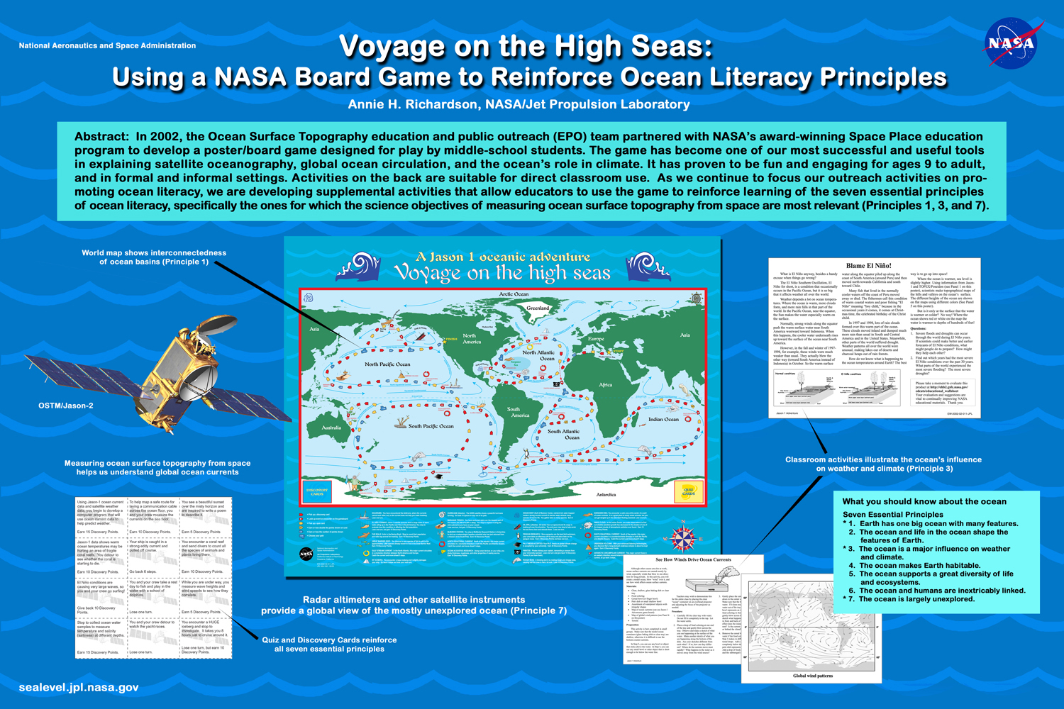
| A. Richardson | Voyage on the high seas: using a Nasa Board game to reinforce ocean literacy principles | pdf (1.3 MB) |
| V. Rosmorduc | Google Earth browse through altimetry applications on Aviso web |
Keynotes talks III
| G. Lagerloef | Linking ocean circulation, the water cycle and climate: New science opportunities with salinity satellite missions. | pdf (8.5 MB) |
| M.H. Rio | Absolute ocean circulation from altimetry: current status and prospects for the upcoming Goce era. | pdf (10 MB) |
Precision orbit determination and geoid - focusing on ITRF, geoid and Mean Sea Surface
| A. Ollivier et al. | Assessment of Jason-2 orbit quality using SSH cross-calibration with Jason-1 and Envisat | pdf (3.8 MB) |
| C. Jayles et al. | Quality of the Doris/Diode orbits for Jason-1, Envisat, Jason-2... and potential improvements | pdf (1 MB) |
| L. Cerri et al. | Impact of long-term gravity field variations on Jason-1 and Jason-2 GDR orbits | pdf(700 KB) |
| R. Biancale et al. | What kind of gravity model for satellite altimetry | pdf (1.6 MB) |
Coastal and inland altimetry
| F. Mercier et al. | Splinter overview | |
Coastal | ||
| M.Cancet et al. | CTOH regional altimetry products: example of scientific applications | pdf (3.8 MB) |
| T. Haack et al. | High-Resolution Model Fields of Wet-Troposphere Path Delay in Coastal Regions | pdf (3.8 MB) |
Inland | ||
| A. Pascual et al. | Synergy between glider and coastal altimetry: Case study in the Balearic Sea | pdf (1.5 MB) |
| G. Quartly et al. | Singular reflections on the Golfo della Botte | pdf (1.7 MB) |
| F. Mercier et al. | The PISTACH project for Hydrology: project status, products and early results | pdf (3 MB) |
| S. Calmant et al. | Validation of Jason-2 over the Amazon basin rivers | pdf (2.2 MB) |
Instrument | ||
| J.D. Desjonqueres et al. | POSEIDON Diode/DEM coupling mode | pdf (1 MB) |
Wednesday 24 June
Keynote talk IV
| S. Nerem et al. | Sea level change: past, present and future | pdf (34 MB) |
| C. Wunsch et al. | Sampling and systematic errors in the global sea level change | pdf (5 MB) |
Plenary sessions
Sea level error budgets; current status, needs and future improvements
| R. Ponte et al. | Overview | pdf (700 KB) |
| J. Dorandeu et al. | Introduction/Overview: from a global system error budget to application-specific error budgets | pdf (3 MB) |
| M. Ablain et al. | Estimation of the global and regional mean sea level trends from Jason-1&2 and T/P data | pdf (3 MB) |
| G. Mitchum et al. | Global sea level rise uncertainty due to land motion and reference frame issues | pdf (45 KB) |
| D. Chambers et al. | A Proposal for Tighter Stability Requirements on the Wet Path Delay Correction for Jason-3 | pdf (2.4 MB) |
| S. Brown et al. | On the Long Term Stability of the Radiometer Wet Tropospheric Path Delay Retrieval: Past, Present and a Proposal for the Future on Jason-3 | pdf (6.6 MB) |
| R. Ray et al. | Tide Correction Errors | pdf (1.1 MB) |
| F. Lyard et al. | Precise error budget for the altimeter-derived tidal constants (in shelf and coastal seas) | pdf (16 MB) |
| D. Vandemark et al. | Present uncertainties and future refinement of the sea state bias correction | pdf (8.5 MB) |
| A. Kaplan et al. | Error in gridded sea surface height products | pdf (7 MB) |
GDR Assessment and recommandations
| Cnes, Nasa, Noaa & Eumetsat | GDR status | pdf (2.3 MB) |
Splinter meeting summaries
| F. Lemoine et al. | POD and geoid | pdf (1.2 MB) |
| S. Brown et al. | Instrument processing | pdf (3.7 MB) |
| H. Bonekamp et al. | Near-Real time processing | pdf (3.8 MB) |
| P. Bonnefond et al. | Local Calibration/Validation | pdf (4.6 MB) |
| F. Mercier et al. | Coastal and inland altimetry | pdf (3 MB) |
| V. Rosmorduc et al. | Outreach | pdf (17 MB) |
Coin utilisateur
 Informations utiles .
- Equipes scientifiques .
- Swot Science Team .
- SARAL/AltiKa Science Team .
- OSTST - SWT Science Team .
- OSTST PIs Abstracts .
- OSTST 2023 (Puerto Rico).
- OSTST 2022 (Venice).
- OSTST 2022 March (Virtual Meeting).
- OSTST 2020 (Virtual meeting).
- OSTST 2019 (Chicago).
- OSTST 2018 (Ponta Delgada).
- OSTST 2017 (Miami).
- OSTST 2016 (La Rochelle).
- OSTST 2015 (Reston).
- OSTST 2014 (Lake Constance).
- OSTST 2013 (Boulder) .
- OSTST 2012 (Venice) .
- OSTST 2011 (San Diego) .
- OSTST 2010 (Lisbon) .
- OSTST 2009 (Seattle) .
- Presentations.
- Posters.
- OSTST 2008 (Nice) .
- OSTST 2007 (Hobart).
- OSTST 2006 (Venice).
- OSTST 2004 (St. Petersburg).
- SWT 2003 (Arles).
- SWT 2002 (New Orleans).
- SWT 2002 (Biarritz).
- SWT 2001 (Solvang).
- SWT 2000 (Miami Beach).
- SWT 1999 (Saint-Raphaël).
- SWT 1998 (Keystone).
- Atelier Altimétrie et Glaciologie.


